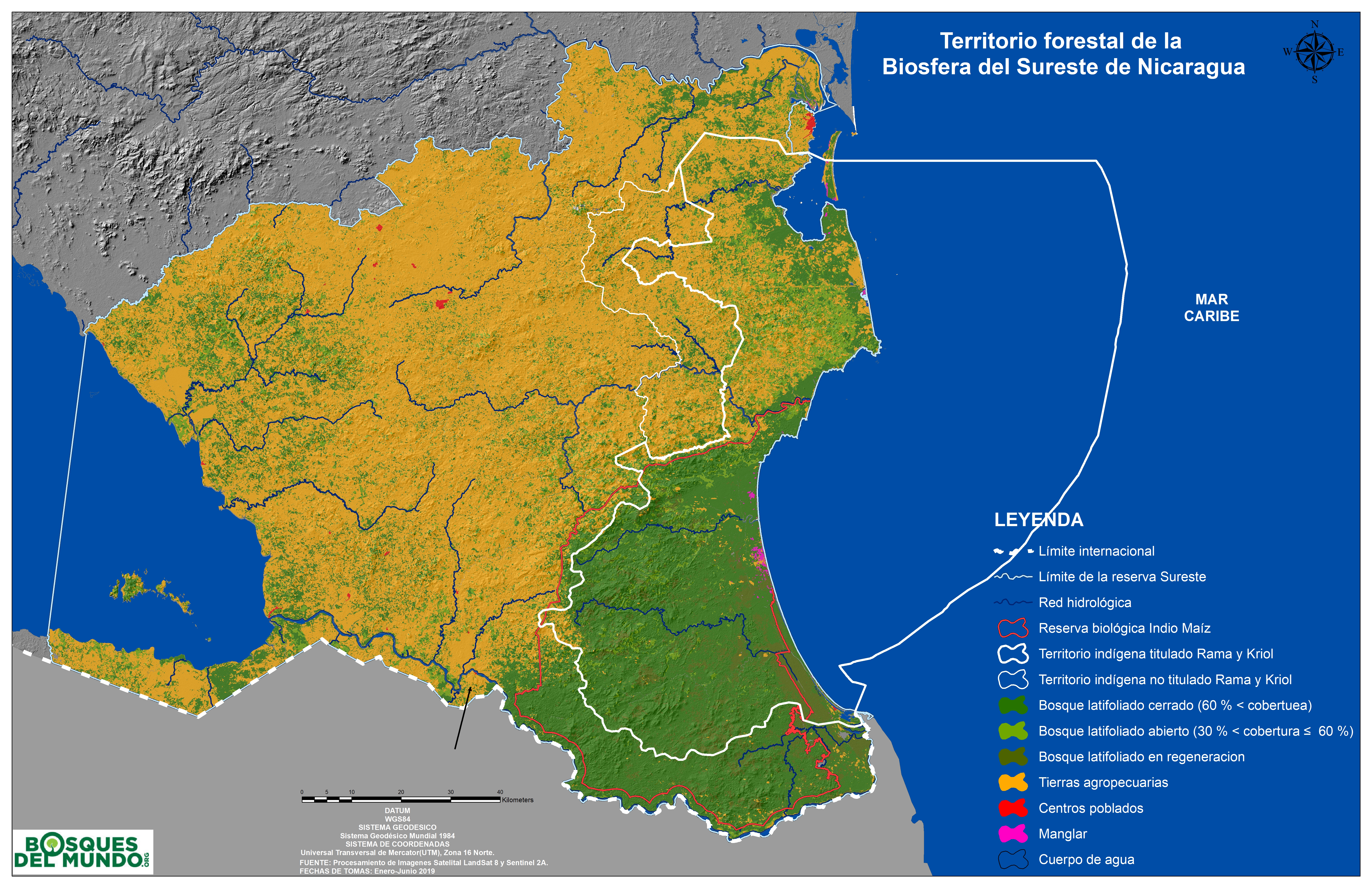
Dispossesions in the Americas

Dispossesions in the Americas

  • Home
  • Explore
  • About
  • Authors
  • Art
  • Bodies
  • Curricula
  • Cultural Heritage
  • Maps
  • Territories
Back to Explore
Map 1984 - 2019

Territorio forestal de la Biosfera del Sureste de Nicaragua.

  • FORESTS OF THE WORLD

Published: 2019

  • Download Image

Peoples

  • RAMA
  • KRIOL

Citation

Territorio forestal de la Biosfera del Sureste de Nicaragua. Forests of the World. DATUM WGS84 Sistema GEODESICO Sistemo Geodésico Mundial 1984 . Fuente: Procesamiento de Imagenes Satelital LandSat 8 y Sentinal 2A. Fechas de Tomas: Enero-Junio 2019. Accessed July 10 2023 https://www.forestsoftheworld.org/files/International.forestsoftheworld.org/Kort/Ny%20Kort/NIC_ReservaSureste_RBIM_TRK_Uso2019.jpg

  • Download Image

Reading in Spanish

Map 1984 - 2019

Territorio forestal de la Biosfera del Sureste de Nicaragua.

  • FORESTS OF THE WORLD

Published: 2019

  • Download Image
  • Download Image

Reading in Portuguese

Map 1984 - 2019

Territorio forestal de la Biosfera del Sureste de Nicaragua.

  • FORESTS OF THE WORLD

Published: 2019

  • Download Image

Peoples

  • RAMA
  • KRIOL

Citation

Territorio forestal de la Biosfera del Sureste de Nicaragua. Forests of the World. DATUM WGS84 Sistema GEODESICO Sistemo Geodésico Mundial 1984 . Fuente: Procesamiento de Imagenes Satelital LandSat 8 y Sentinal 2A. Fechas de Tomas: Enero-Junio 2019. Accessed July 10 2023 https://www.forestsoftheworld.org/files/International.forestsoftheworld.org/Kort/Ny%20Kort/NIC_ReservaSureste_RBIM_TRK_Uso2019.jpg

  • Download Image

Related Content

Carte de la Partie de l'Ocean

Carte de la Partie de l'Ocean

Map 1737
MANJUI

MANJUI

Map 2015
EMBOUCHÛRE DE LA RIVIERE DES AMAZONES

EMBOUCHÛRE DE LA RIVIERE DES AMAZONES

Map 1700 - 1799
SOUTHERN BRAZIL

SOUTHERN BRAZIL

Map 2018
MIDWEST HIGHLANDS OF GUATEMALA, POPULATION ESTIMATES AS OF 1937

MIDWEST HIGHLANDS OF GUATEMALA, POPULATION ESTIMATES AS OF 1937

Map 1937
San Miguel

San Miguel

Map 1997
Totocanapan: Approximate Extension in Ancient and Recent Times

Totocanapan: Approximate Extension in Ancient and Recent Times

Map 1940
Indigenous peoples of the coast of Brazil, (c. 16th C.)

Indigenous peoples of the coast of Brazil, (c. 16th C.)

Map 1500 - 1599

Dispossessions in the Americas

A project by

University of Pennsylvania

Copyright 2024

With support from

Mellon Foundation

Site design & development

Element 84

Art Credits

Territorio forestal de la Biosfera del Sureste de Nicaragua. Forests of the World. DATUM WGS84 Sistema GEODESICO Sistemo Geodésico Mundial 1984 . Fuente: Procesamiento de Imagenes Satelital LandSat 8 y Sentinal 2A. Fechas de Tomas: Enero-Junio 2019. Accessed July 10 2023 https://www.forestsoftheworld.org/files/International.forestsoftheworld.org/Kort/Ny%20Kort/NIC_ReservaSureste_RBIM_TRK_Uso2019.jpg

Site Pages

  • Home
  • Explore
  • About
  • Authors
  • Art
  • Bodies
  • Curricula
  • Cultural Heritage
  • Maps
  • Territories