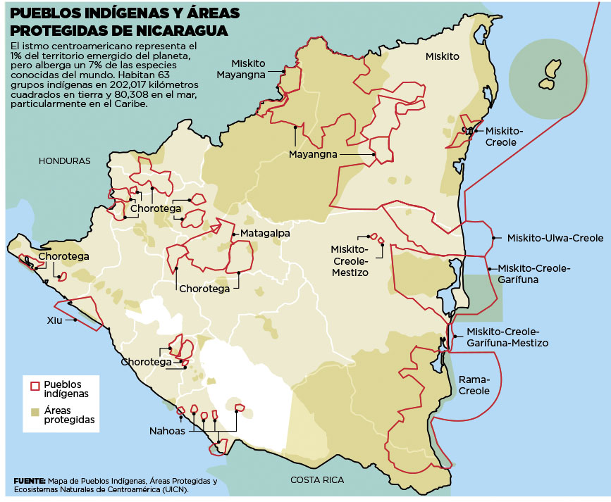
Dispossesions in the Americas

Dispossesions in the Americas

  • Home
  • Explore
  • About
  • Authors
  • Art
  • Bodies
  • Curricula
  • Cultural Heritage
  • Maps
  • Territories
Back to Explore
Map 2000

Pueblos Indígenas;Áreas Protegidas de Nicaragua

  • UICN

  • Download Image

Peoples

  • CHOROTEGA
  • XIU
  • NAHOAS
  • RAMA CREOLE
  • MATAGALPA
  • MISKITO
  • MAYANGNA
  • MISKITO GARIFUNA
  • MISKITO CREOLE
  • MISKITO-ULWA-CREOLE

Citation

UICN. Pueblos Indígenas y Areas Protegidas de Nicaragua;Mapa de Pueblos Indígenas;Areas Protegidas;y Ecosistemas Naturales de Centroamerica (UICN). Image courtesy of El Nuevo Dario. Accessed July 10 2023. https://nathanielmorris.co.uk/nicaragua/

  • Download Image

Reading in Spanish

Map 2000

Pueblos Indígenas;Áreas Protegidas de Nicaragua

  • UICN

  • Download Image
  • Download Image

Reading in Portuguese

Map 2000

Pueblos Indígenas;Áreas Protegidas de Nicaragua

  • UICN

  • Download Image

Peoples

  • CHOROTEGA
  • XIU
  • NAHOAS
  • RAMA CREOLE
  • MATAGALPA
  • MISKITO
  • MAYANGNA
  • MISKITO GARIFUNA
  • MISKITO CREOLE
  • MISKITO-ULWA-CREOLE

Citation

UICN. Pueblos Indígenas y Areas Protegidas de Nicaragua;Mapa de Pueblos Indígenas;Areas Protegidas;y Ecosistemas Naturales de Centroamerica (UICN). Image courtesy of El Nuevo Dario. Accessed July 10 2023. https://nathanielmorris.co.uk/nicaragua/

  • Download Image

Related Content

PUEBLO CHOL

PUEBLO CHOL

Map 2020
PLANO QUE SE ADJUNTA AL PROCESO QUE SIGUEN LOS INDÍGENAS DE LA COMUNIDAD DE COLAMBO;LOJA CONTRA DIEGO BRICINO A QUIEN ACUSAN DE HABERSE APROPIADO DE LAS TIERRAS DE ESTA COMUNIDAD

PLANO QUE SE ADJUNTA AL PROCESO QUE SIGUEN LOS INDÍGENAS DE LA COMUNIDAD DE COLAMBO;LOJA CONTRA DIEGO BRICINO A QUIEN ACUSAN DE HABERSE APROPIADO DE LAS TIERRAS DE ESTA COMUNIDAD

Map 1697
Protected Natural Areas in the Maya Region

Protected Natural Areas in the Maya Region

Map 2000 - 2100
A New Chart of the Coast of Brazil from the Banks of St. Roque, to the Island of St. Sebastian;with the Islands and Soundings in the Offing

A New Chart of the Coast of Brazil from the Banks of St. Roque, to the Island of St. Sebastian;with the Islands and Soundings in the Offing

Map 1794
PUEBLO PA IPAI

PUEBLO PA IPAI

Map 2020
Map representing the linguistic diversity that existed in Central America and the Gulf of Fonseca at the time of contact with the Spanish

Map representing the linguistic diversity that existed in Central America and the Gulf of Fonseca at the time of contact with the Spanish

Map 1522
Cartografía hispano colonial de Chile

Cartografía hispano colonial de Chile

Map 1500 - 1800
Map of the Republic of Guatemala

Map of the Republic of Guatemala

Map 1800

Dispossessions in the Americas

A project by

University of Pennsylvania

Copyright 2024

With support from

Mellon Foundation

Site design & development

Element 84

Art Credits

UICN. Pueblos Indígenas y Areas Protegidas de Nicaragua;Mapa de Pueblos Indígenas;Areas Protegidas;y Ecosistemas Naturales de Centroamerica (UICN). Image courtesy of El Nuevo Dario. Accessed July 10 2023. https://nathanielmorris.co.uk/nicaragua/

Site Pages

  • Home
  • Explore
  • About
  • Authors
  • Art
  • Bodies
  • Curricula
  • Cultural Heritage
  • Maps
  • Territories