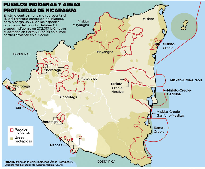
Dispossesions in the Americas

Dispossesions in the Americas

  • Home
  • Explore
  • About
  • Authors
  • Art
  • Bodies
  • Curricula
  • Cultural Heritage
  • Maps
  • Territories
Back to Explore
Map 2000

Pueblos Indígenas;Áreas Protegidas de Nicaragua

  • UICN

  • Download Image

Peoples

  • CHOROTEGA
  • XIU
  • NAHOAS
  • RAMA CREOLE
  • MATAGALPA
  • MISKITO
  • MAYANGNA
  • MISKITO GARIFUNA
  • MISKITO CREOLE
  • MISKITO-ULWA-CREOLE

Citation

UICN. Pueblos Indígenas y Areas Protegidas de Nicaragua;Mapa de Pueblos Indígenas;Areas Protegidas;y Ecosistemas Naturales de Centroamerica (UICN). Image courtesy of El Nuevo Dario. Accessed July 10 2023. https://nathanielmorris.co.uk/nicaragua/

  • Download Image

Reading in Spanish

Map 2000

Pueblos Indígenas;Áreas Protegidas de Nicaragua

  • UICN

  • Download Image
  • Download Image

Related Content

CARTE que représente la Partie Méridionale DU BRÉSIL ET DU PEROU;LE CHILI SEPTENTRIONAL;EL LE PARAGUAY;Ce qui fait la Pártie de milieu DE L’AMÉRIQUE MERIDIONALE PAR LE SR. D’ANVILLE À VENISE Par P. Santini 1779. Chez M’.Remondiri.

CARTE que représente la Partie Méridionale DU BRÉSIL ET DU PEROU;LE CHILI SEPTENTRIONAL;EL LE PARAGUAY;Ce qui fait la Pártie de milieu DE L’AMÉRIQUE MERIDIONALE PAR LE SR. D’ANVILLE À VENISE Par P. Santini 1779. Chez M’.Remondiri.

Map 1779
PUEBLO OLUTECO

PUEBLO OLUTECO

Map 2020
Carte de l'Isle de Caïenne et des rivières voisines dans laquelle on a marqué nommément toutes les habitations qui composent actuellement cette colonie françoise

Carte de l'Isle de Caïenne et des rivières voisines dans laquelle on a marqué nommément toutes les habitations qui composent actuellement cette colonie françoise

Map 1729
Población es-pei (cucupá) en 2010

Población es-pei (cucupá) en 2010

Map 2010
TERRITORIO DEL SEÑORÍO  AYMARA DE LOS KILLAKAS A PRINCIPIOS DEL SIGLO XVI

TERRITORIO DEL SEÑORÍO AYMARA DE LOS KILLAKAS A PRINCIPIOS DEL SIGLO XVI

Map 1500 - 1530
Map 2.3 The multilingual context of French Guiana (from Renault-Lescure and Goury 2009: 10)

Map 2.3 The multilingual context of French Guiana (from Renault-Lescure and Goury 2009: 10)

Map 2012
Geographic Distribution of the Chatino

Geographic Distribution of the Chatino

Map 1969
TITLED INDIGENOUS TERRITORIES (TIOCs) IN THE BOLIVIAN HIGH PLATEAU by 2011

TITLED INDIGENOUS TERRITORIES (TIOCs) IN THE BOLIVIAN HIGH PLATEAU by 2011

Map 2011

Dispossessions in the Americas

A project by

University of Pennsylvania

Copyright 2024

With support from

Mellon Foundation

Site design & development

Element 84

Art Credits

UICN. Pueblos Indígenas y Areas Protegidas de Nicaragua;Mapa de Pueblos Indígenas;Areas Protegidas;y Ecosistemas Naturales de Centroamerica (UICN). Image courtesy of El Nuevo Dario. Accessed July 10 2023. https://nathanielmorris.co.uk/nicaragua/

Site Pages

  • Home
  • Explore
  • About
  • Authors
  • Art
  • Bodies
  • Curricula
  • Cultural Heritage
  • Maps
  • Territories