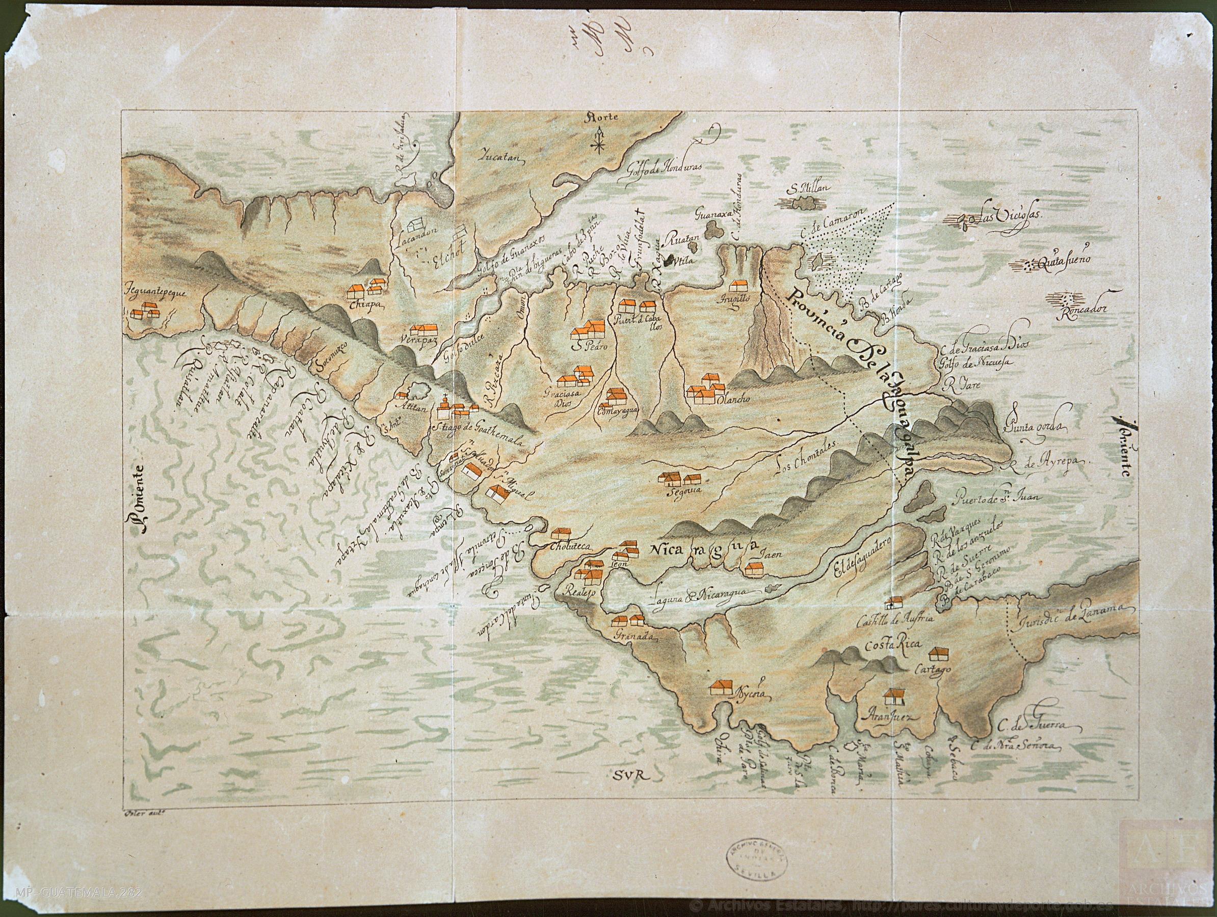
Dispossesions in the Americas

Dispossesions in the Americas

  • Home
  • Explore
  • About
  • Authors
  • Art
  • Bodies
  • Curricula
  • Cultural Heritage
  • Maps
  • Territories
Back to Explore
Map 1800 - 1801

Costa Rica;Nicaragua;Guatemala y Honduras

    Published: 1801

    • Download Image

    Peoples

    • LACANDON
    • CHONTALES

    Citation

    "Costa Rica;Nicaragua;Guatemala y Honduras" Probable 1801. MP-GUATEMALA;282. ES.41091.AGI//MP-GUATEMALA;282 Archivo General de Indias. Accessed June 22 2023. http://pares.mcu.es/ParesBusquedas20/catalogo/show/19925

    • Download Image

    Reading in Spanish

    Map 1800 - 1801

    Costa Rica;Nicaragua;Guatemala y Honduras

      Published: 1801

      • Download Image
      • Download Image

      Related Content

      Map of Nicaragua showing Ulwa settlements in Eastern Nicaragua and field study sites (in rectangle)

      Map of Nicaragua showing Ulwa settlements in Eastern Nicaragua and field study sites (in rectangle)

      Map 1990
      Diseño hecho á pluma de territorio que ocupan los ingleses en la costa de Mosquitos junto al Río Tinto.

      Diseño hecho á pluma de territorio que ocupan los ingleses en la costa de Mosquitos junto al Río Tinto.

      Map 1774
      PUEBLO MIXTECO

      PUEBLO MIXTECO

      Map 2020
      Cultural groups discussed in the text

      Cultural groups discussed in the text

      Map 2010
      CARTA GEOGRÁFICA DE UNA GRAN PARTE DE LA AMERICA SEPTENTRIONAL

      CARTA GEOGRÁFICA DE UNA GRAN PARTE DE LA AMERICA SEPTENTRIONAL

      Map 1832
      VISTA DE LA NUEVA POBLACION DE SAN FERNANDO DE GUADALUPE EN EL SALTO DE AGUA DEL RIO TULIJA, QUE LLEVA SU CORRIENTE A LAS LAGUNAS DE CHICHICASTE Y DE TÉRMINOS

      VISTA DE LA NUEVA POBLACION DE SAN FERNANDO DE GUADALUPE EN EL SALTO DE AGUA DEL RIO TULIJA, QUE LLEVA SU CORRIENTE A LAS LAGUNAS DE CHICHICASTE Y DE TÉRMINOS

      Map 1795
      Croquis III. (b) La región andina septentrional ecuatoriana (Moreno Yanez;1989;2)

      Croquis III. (b) La región andina septentrional ecuatoriana (Moreno Yanez;1989;2)

      Map -500 - 1530
      An exact draught of the Gulf of Darien & the coast to Porto Bello with Panama in the South sea & the Scotch settlement in Calledonia

      An exact draught of the Gulf of Darien & the coast to Porto Bello with Panama in the South sea & the Scotch settlement in Calledonia

      Map 1700 - 1799

      Dispossessions in the Americas

      A project by

      University of Pennsylvania

      Copyright 2024

      With support from

      Mellon Foundation

      Site design & development

      Element 84

      Art Credits

      “Costa Rica;Nicaragua;Guatemala y Honduras” Probable 1801. MP-GUATEMALA;282. ES.41091.AGI//MP-GUATEMALA;282 Archivo General de Indias. Accessed June 22 2023. http://pares.mcu.es/ParesBusquedas20/catalogo/show/19925

      Site Pages

      • Home
      • Explore
      • About
      • Authors
      • Art
      • Bodies
      • Curricula
      • Cultural Heritage
      • Maps
      • Territories