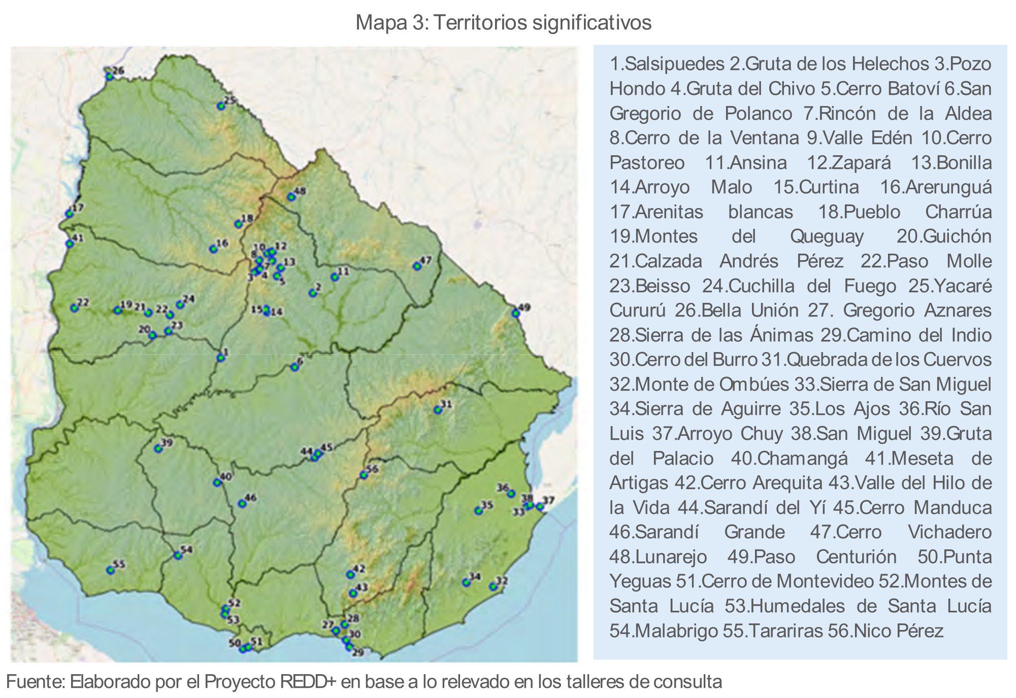
Dispossesions in the Americas

Dispossesions in the Americas

  • Home
  • Explore
  • About
  • Authors
  • Art
  • Bodies
  • Curricula
  • Cultural Heritage
  • Maps
  • Territories
Back to Explore
Map 1500 - 1599

PINTURA DE GUEGUETLÁN

    Published: 1581

    • Download Image

    Citation

    Unknown "Pintura de Gueguetlan." Map. 1579. Benson Latin American Collection, LLILAS Benson Latin American Studies and Collections, The University of Texas at Austin https://www.artsy.net/article/artsy-editorial-indigenous-artists-maps-tools-resistance-colonial-mexico

    • Download Image

    Reading in Spanish

    Map 1500 - 1599

    PINTURA DE GUEGUETLÁN

      Published: 1581

      • Download Image
      • Download Image

      Reading in Portuguese

      Map 1500 - 1599

      PINTURA DE GUEGUETLÁN

        Published: 1581

        • Download Image

        Citation

        Unknown "Pintura de Gueguetlan." Map. 1579. Benson Latin American Collection, LLILAS Benson Latin American Studies and Collections, The University of Texas at Austin https://www.artsy.net/article/artsy-editorial-indigenous-artists-maps-tools-resistance-colonial-mexico

        • Download Image

        Related Content

        PROVINCIA DE SAPUCAHY

        PROVINCIA DE SAPUCAHY

        Map 1873
        Proyecto "Sinsiña" ["Sinsiña" Project]

        Proyecto "Sinsiña" ["Sinsiña" Project]

        Artwork
        Carte de l'entrée de la Rivière d'Oyapoc jusqu'aux premiers sauts.

        Carte de l'entrée de la Rivière d'Oyapoc jusqu'aux premiers sauts.

        Map 1700 - 1799
        PLAN of the Isle GRANDE & the adjacent parts of the COAST of BRAZIL

        PLAN of the Isle GRANDE & the adjacent parts of the COAST of BRAZIL

        Map 1764
        America sive India nova ad magnae Gerardi Mercatoris avi universalis imitationem in compendium. Redacta per Michaelem Mercatorem Duysburgensem

        America sive India nova ad magnae Gerardi Mercatoris avi universalis imitationem in compendium. Redacta per Michaelem Mercatorem Duysburgensem

        Map 1600 - 1699
        The Great River Marañon or of the Amazons

        The Great River Marañon or of the Amazons

        Map 1717
        Territorios significativos

        Territorios significativos

        Map 2010 - 2020
        "Plano que demuestra la inmediación de Quibdó, último pueblo de Chocó, con los Indios Bárbaros nombrados Cunacunas, entre los que se hallan mezclados diferentes Naciones, como son ingleses, franceses, &."

        "Plano que demuestra la inmediación de Quibdó, último pueblo de Chocó, con los Indios Bárbaros nombrados Cunacunas, entre los que se hallan mezclados diferentes Naciones, como son ingleses, franceses, &."

        Map 1753

        Dispossessions in the Americas

        A project by

        University of Pennsylvania

        Copyright 2024

        With support from

        Mellon Foundation

        Site design & development

        Element 84

        Art Credits

        Unknown “Pintura de Gueguetlan.” Map. 1579. Benson Latin American Collection, LLILAS Benson Latin American Studies and Collections, The University of Texas at Austin https://www.artsy.net/article/artsy-editorial-indigenous-artists-maps-tools-resistance-colonial-mexico

        Site Pages

        • Home
        • Explore
        • About
        • Authors
        • Art
        • Bodies
        • Curricula
        • Cultural Heritage
        • Maps
        • Territories