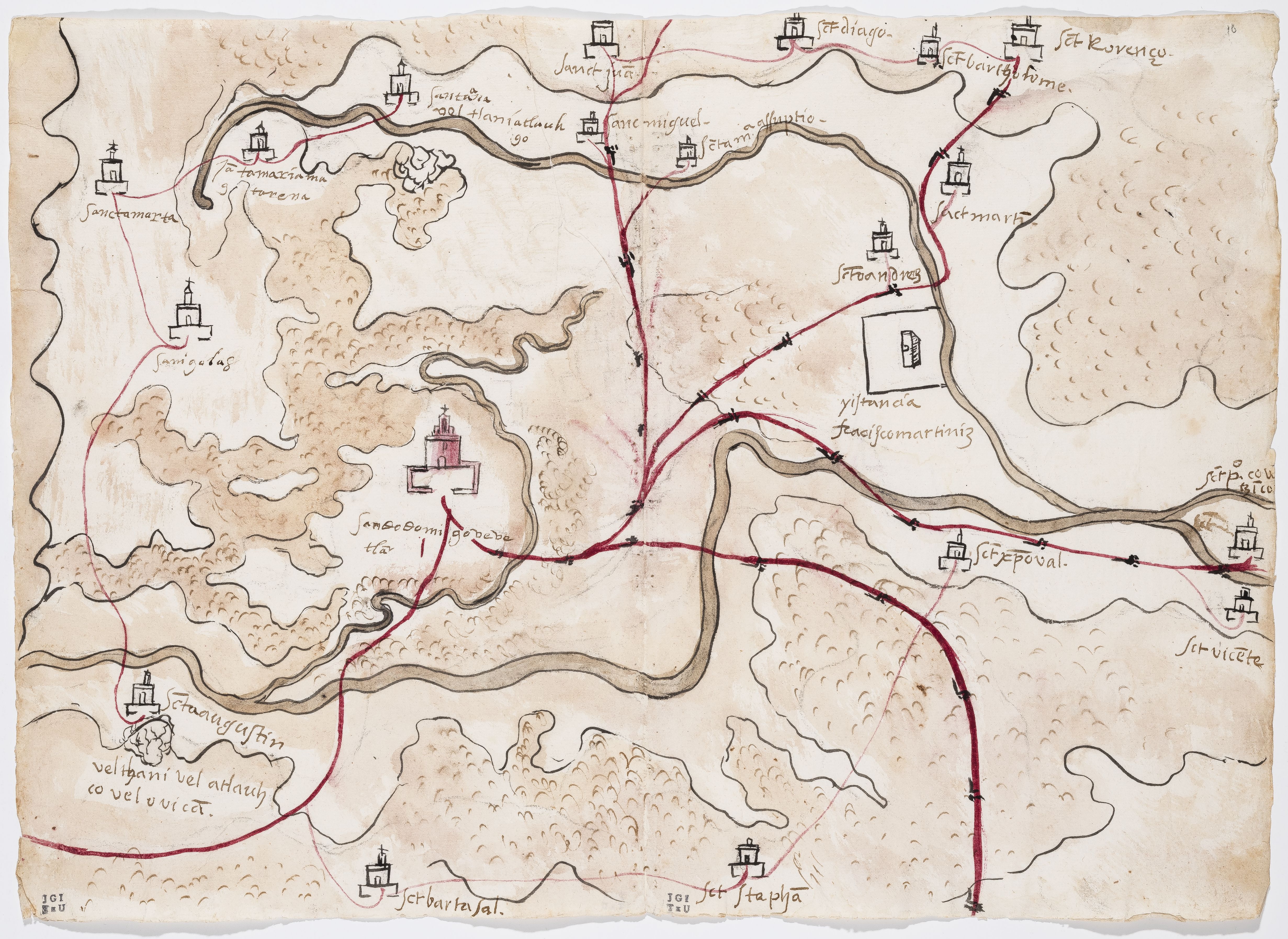
Dispossesions in the Americas

Dispossesions in the Americas

  • Home
  • Explore
  • About
  • Authors
  • Art
  • Bodies
  • Curricula
  • Cultural Heritage
  • Maps
  • Territories
Back to Explore
Map 1500 - 1599

PINTURA DE GUEGUETLAN

    Published: 1579

    • Download Image

    Citation

    Unknown. Pintura de Gueguetlan. Map. Benson Latin American Collection, LLILAS Benson Latin American Studies and Collections, The University of Texas at Austin, 1579. Relaciones Geográficas of Mexico and Guatemala https://txarchives.org/utlac/finding_aids/00056.xml

    • Download Image

    Reading in Spanish

    Map 1500 - 1599

    PINTURA DE GUEGUETLAN

      Published: 1579

      • Download Image
      • Download Image

      Reading in Portuguese

      Map 1500 - 1599

      PINTURA DE GUEGUETLAN

        Published: 1579

        • Download Image

        Citation

        Unknown. Pintura de Gueguetlan. Map. Benson Latin American Collection, LLILAS Benson Latin American Studies and Collections, The University of Texas at Austin, 1579. Relaciones Geográficas of Mexico and Guatemala https://txarchives.org/utlac/finding_aids/00056.xml

        • Download Image

        Related Content

        Nos roban las palabras o A Calzón quitado, o Insurrecciones que son heréticas resurrecciones [They steal our words or Barefaced, or Insurrections that are Heretical Resurrections]

        Nos roban las palabras o A Calzón quitado, o Insurrecciones que son heréticas resurrecciones [They steal our words or Barefaced, or Insurrections that are Heretical Resurrections]

        Artwork
        CHOL REGION AND THE LACANDON FOREST

        CHOL REGION AND THE LACANDON FOREST

        Map 1998
        Karte der Umgebung von Caicara in Venezuela

        Karte der Umgebung von Caicara in Venezuela

        Map 1908 - 1909
        A draught of the country near Blewfields Bluff on the Mosquito Shore

        A draught of the country near Blewfields Bluff on the Mosquito Shore

        Map 1757
        Mapa de la tierra donde habitan los indios, Piles Timbas y Barbacoas

        Mapa de la tierra donde habitan los indios, Piles Timbas y Barbacoas

        Map 1610
        Veragua y parte de Costa-Rica

        Veragua y parte de Costa-Rica

        Map 1600 - 1699
        PUEBLO KICHWA

        PUEBLO KICHWA

        Map 2021
        Mexico at the time of the conquest (1519), showing the extent of the Culhua Mexica (Aztec Empire) and of the Maya holdings

        Mexico at the time of the conquest (1519), showing the extent of the Culhua Mexica (Aztec Empire) and of the Maya holdings

        Map 1519

        Dispossessions in the Americas

        A project by

        University of Pennsylvania

        Copyright 2024

        With support from

        Mellon Foundation

        Site design & development

        Element 84

        Art Credits

        Unknown. Pintura de Gueguetlan. Map. Benson Latin American Collection, LLILAS Benson Latin American Studies and Collections, The University of Texas at Austin, 1579. Relaciones Geográficas of Mexico and Guatemala https://txarchives.org/utlac/finding_aids/00056.xml

        Site Pages

        • Home
        • Explore
        • About
        • Authors
        • Art
        • Bodies
        • Curricula
        • Cultural Heritage
        • Maps
        • Territories