Citation
Comisión Nacional para el Desarrollo de los Pueblos Indígenas. Regiones indígenas de México. Publication no. 330.972. 2006. https://www.gob.mx/cms/uploads/attachment/file/35735/cdi-regiones-indigenas-mexico.pdf.
![Los amarillos [The Yellow Ones]](https://dnet8ble6lm7w.cloudfront.net/art_sm/ACOL017.png)
Los amarillos [The Yellow Ones]
Artwork
MAPA O CARTA GEOGRÁFICA DE LA PROVINCIA DE VENEZUELA. LA CAPITAL ES LA CIUDAD DE SANTIAGO DE LÉON DE CARACAS.
Map 1780![Libro para visitas para Seropositivo [Guestbook for Seropositive]](https://dnet8ble6lm7w.cloudfront.net/art_sm/ACOL010.png)
Libro para visitas para Seropositivo [Guestbook for Seropositive]
Artwork
AMAZONIA;TERRAFIRMA;Part of BRASIL and PERÚ
Map 1735
MAPA QUE COMPRENDE TODO EL DISTRITO DE LA AUDIENCIA DE QUITO
Map 1779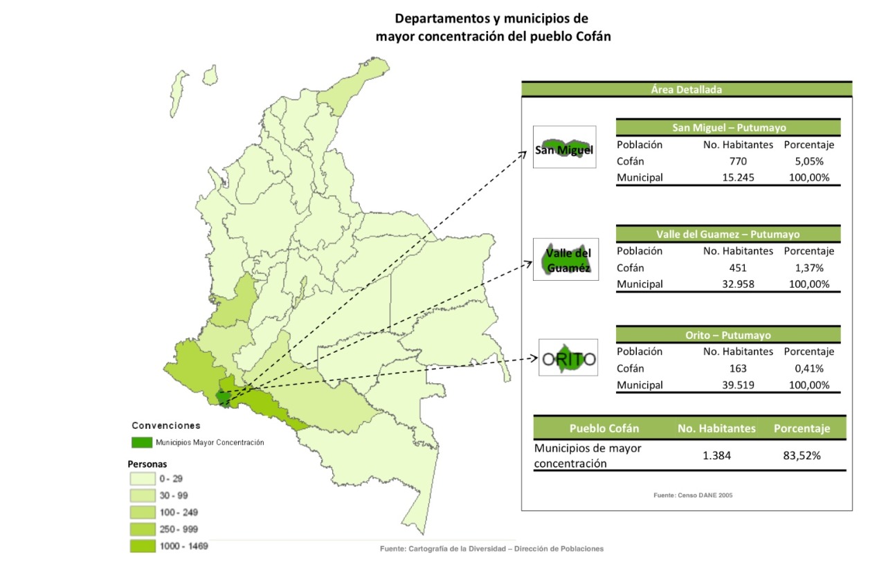
Departamentos y municipios de mayor concentración del pueblo Cofán
Map 2005
A Map of part of Yucatan or of that Part of the Eastern Shore Within the Bay of Honduras Alloted to Great Britain for the Cutting of Logwood, in consequence of the Convention Signed with Spain on the 14th July 1786.
Map 1700![Pátria, sangue e nada mais [Homeland, Blood and Nothing More]](https://dnet8ble6lm7w.cloudfront.net/art_sm/ABRA010.png)
Pátria, sangue e nada mais [Homeland, Blood and Nothing More]
Artwork