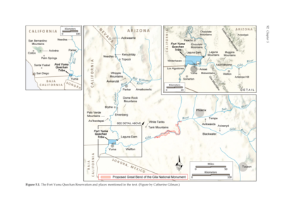
Dispossesions in the Americas

Dispossesions in the Americas

  • Home
  • Explore
  • About
  • Authors
  • Art
  • Bodies
  • Curricula
  • Cultural Heritage
  • Maps
  • Territories
Back to Explore
Map 2015

CHIHUAHUA

  • INSTITUTO NACIONAL DE LOS PUEBLOS INDIGENAS

  • Download Image

Peoples

  • GUARIJIO
  • PIMA
  • TARAHUMARA
  • TEPEHUANO DEL NORTE

Citation

Instituto Nacional de los Pueblos Indígenas. "Distribución por Entidad Federativa." Atlas de los pueblos indígenas de México. http://atlas.inpi.gob.mx/distribucion-por-entidad-federativa/.

  • Download Image

Reading in Spanish

Map 2015

CHIHUAHUA

  • INSTITUTO NACIONAL DE LOS PUEBLOS INDIGENAS

  • Download Image
  • Download Image

Reading in Portuguese

Map 2015

CHIHUAHUA

  • INSTITUTO NACIONAL DE LOS PUEBLOS INDIGENAS

  • Download Image

Peoples

  • GUARIJIO
  • PIMA
  • TARAHUMARA
  • TEPEHUANO DEL NORTE

Citation

Instituto Nacional de los Pueblos Indígenas. "Distribución por Entidad Federativa." Atlas de los pueblos indígenas de México. http://atlas.inpi.gob.mx/distribucion-por-entidad-federativa/.

  • Download Image

Related Content

PUEBLO ASHANINKA

PUEBLO ASHANINKA

Map 2021
Mapa del SIGAP (Sistema Guatemalteco de Áreas Protegidas)

Mapa del SIGAP (Sistema Guatemalteco de Áreas Protegidas)

Map 2012
La región andina septentrional ecuatoriana

La región andina septentrional ecuatoriana

Map -500 - 1550
Pueblos indígenas en el Perú amazónico

Pueblos indígenas en el Perú amazónico

Map 2009
The Fort Yuma Reservation and Places Mentioned in the Text

The Fort Yuma Reservation and Places Mentioned in the Text

Map 2016
MAPA ETNOGRÁFICO

MAPA ETNOGRÁFICO

Map 1500 - 1900
Carte des environs de Cap de nord dressée par ordre de M. M. les administrateurs déposée par le Sr. houlet à M. Mentelle Cap.ne. d'infanterie garde du dépôt des cartes et plans de la colonie de Cayenne ingénieur géographe du Roi.

Carte des environs de Cap de nord dressée par ordre de M. M. les administrateurs déposée par le Sr. houlet à M. Mentelle Cap.ne. d'infanterie garde du dépôt des cartes et plans de la colonie de Cayenne ingénieur géographe du Roi.

Map 1787
MAPPA DA PROVINCIA DE MINAS GERAES

MAPPA DA PROVINCIA DE MINAS GERAES

Map 1826

Dispossessions in the Americas

A project by

University of Pennsylvania

Copyright 2024

With support from

Mellon Foundation

Site design & development

Element 84

Art Credits

Instituto Nacional de los Pueblos Indígenas. “Distribución por Entidad Federativa.” Atlas de los pueblos indígenas de México. http://atlas.inpi.gob.mx/distribucion-por-entidad-federativa/.

Site Pages

  • Home
  • Explore
  • About
  • Authors
  • Art
  • Bodies
  • Curricula
  • Cultural Heritage
  • Maps
  • Territories