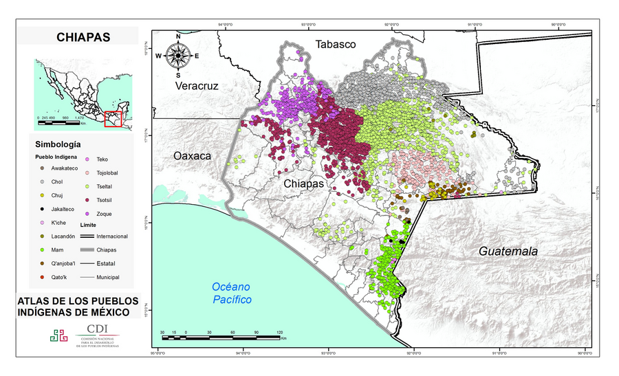
Dispossesions in the Americas

Dispossesions in the Americas

  • Home
  • Explore
  • About
  • Authors
  • Art
  • Bodies
  • Curricula
  • Cultural Heritage
  • Maps
  • Territories
Back to Explore
Map 2015

CHIAPAS

  • INSTITUTO NACIONAL DE LOS PUEBLOS INDIGENAS

  • Download Image

Peoples

  • AWAKATECO
  • CHOL
  • CHUJ
  • JAKALTECO
  • KICHE
  • LACANDON
  • MAM
  • QANJOBAL
  • QATOK
  • TEKO
  • TOJOLABAL
  • TSELTAL
  • TSOTSIL
  • ZOQUE

Citation

Instituto Nacional de los Pueblos Indígenas. "Distribución por Entidad Federativa." Atlas de los pueblos indígenas de México. http://atlas.inpi.gob.mx/distribucion-por-entidad-federativa/.

  • Download Image

Reading in Spanish

Map 2015

CHIAPAS

  • INSTITUTO NACIONAL DE LOS PUEBLOS INDIGENAS

  • Download Image
  • Download Image

Reading in Portuguese

Map 2015

CHIAPAS

  • INSTITUTO NACIONAL DE LOS PUEBLOS INDIGENAS

  • Download Image

Peoples

  • AWAKATECO
  • CHOL
  • CHUJ
  • JAKALTECO
  • KICHE
  • LACANDON
  • MAM
  • QANJOBAL
  • QATOK
  • TEKO
  • TOJOLABAL
  • TSELTAL
  • TSOTSIL
  • ZOQUE

Citation

Instituto Nacional de los Pueblos Indígenas. "Distribución por Entidad Federativa." Atlas de los pueblos indígenas de México. http://atlas.inpi.gob.mx/distribucion-por-entidad-federativa/.

  • Download Image

Related Content

Cover-up of the Ponce de Leon statue at the Antorcha de la Amistad in Miami, Florida

Cover-up of the Ponce de Leon statue at the Antorcha de la Amistad in Miami, Florida

Artwork
PUEBLO CASHINAHUA

PUEBLO CASHINAHUA

Map 2021
Guiana Shewing the Localities of the Principal Indian Nations

Guiana Shewing the Localities of the Principal Indian Nations

Map 1800 - 1899
Mapa de Magallanes

Mapa de Magallanes

Map 1746
NORTHWEST PART OF THE "GREAT COLONIAL MAP"

NORTHWEST PART OF THE "GREAT COLONIAL MAP"

Map 1875
Mapa Histórico - Étnico de los Indios Abipones

Mapa Histórico - Étnico de los Indios Abipones

Map 1600 - 1885
Sitio de estudio

Sitio de estudio

Map 2010 - 2014
Carta/del/Estado/de Guatemala/en Centro-Americ

Carta/del/Estado/de Guatemala/en Centro-Americ

Map 1832

Dispossessions in the Americas

A project by

University of Pennsylvania

Copyright 2024

With support from

Mellon Foundation

Site design & development

Element 84

Art Credits

Instituto Nacional de los Pueblos Indígenas. “Distribución por Entidad Federativa.” Atlas de los pueblos indígenas de México. http://atlas.inpi.gob.mx/distribucion-por-entidad-federativa/.

Site Pages

  • Home
  • Explore
  • About
  • Authors
  • Art
  • Bodies
  • Curricula
  • Cultural Heritage
  • Maps
  • Territories