Peoples
- COCHIMI
- MONQUI
- GUAYCURA
- PERICU
- ARIPA
- EDU
- PIMA ALTO
- APACHE
- SERI
- OPATA
- PIMA BAJO
- TARAUMARA
- CONCHO
- TOBOSO
- COAHUILTECO
- TAMAULIPECO
- PISONES
- JANAMBRES
- OLIVE
- CAHITA
- TEPAHUE
- VAROHIO
- GUAZAPAR
- TUBAR
- ZOE
- BAIMEMA
- GUASAVE
- PIMA
- OGUERA
- CAHUIMETO
- BASOPA
- MEXICANO
- IRRITILA
- TEPEHUAN
- ACAXEE
- TEBACA
- SEBAIBO
- XIXIME
- ZACATECO
- GUACHICHIL
- PAME
- HUAXTECO
- OTOMI
- COCA
- TECUEXE
- TEULES
- CHICHIMECAS
- CAXCAN
- COLOCLAN
- TEPECANO
- CORA
- HUICHOL
- TARASCO
- MAZAHUA
- POPOLOCO
- TOTONACO
- MAZATECO
- CHOCHO
- CHINANTECO
- CUICATECO
- TLAPANECO
- MIXTECO
- AMUCHO
- CHATINO
- ZAPOTECO
- CHONTAL
- TRIQUI
- MIXE
- HUAVE
- ZOQUE
- CHONTAL
- CHIAPANECO
- ZOTZIL
- CHANABAL
- ZENDAL
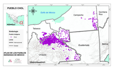
- CHOL
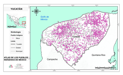
- MAYA
Citation
Orozco y Berra, Manuel. Carta etnográfica de México. Map. Mexico City, 1864. Accessed May 6, 2022. http://bdmx.mx/documento/galeria/carta-etnografica-mexico.