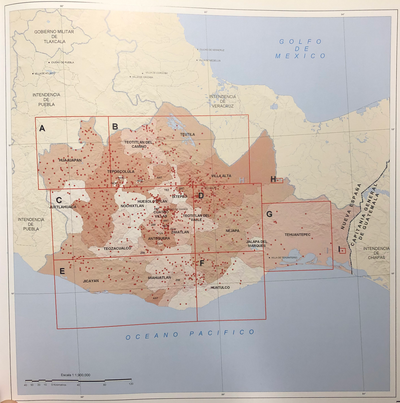
Dispossesions in the Americas

Dispossesions in the Americas

  • Home
  • Explore
  • About
  • Authors
  • Art
  • Bodies
  • Curricula
  • Cultural Heritage
  • Maps
  • Territories
Back to Explore
Map 1843

ANAHUAC Comprenant les Royaumes de Mexico, d'Acolhuacan, de Mechoacan, et les Republiques de Tlascala, de Cholula, de Huexotxinco & Tels qu 'ils etaient das l'annee 1521

  • TH DUVOTENAY

Published: 1521

  • Download Image

Peoples

  • MIXTEC
  • JOPAS
  • ZAPOTEC
  • TLAHUICAN
  • CUITLATEC
  • CHICHIMECA
  • OTOMI

Citation

Duvotenay. Anahuac Comprenant les Royaumes de Mexico, d'Acolhuacan, de Mechoacan, et les Republiques de Tlascala, de Cholula, de Huexotxinco & Tels qu 'ils etaient das l'annee 1521. Map. Paris: Lemaitre, 1843. https://briandimambro.com/products/mexico-aztec-empire-at-time-of-spanish-conquest-1843-duvotenay-historical-map.

  • Download Image

Reading in Spanish

Map 1843

ANAHUAC Comprenant les Royaumes de Mexico, d'Acolhuacan, de Mechoacan, et les Republiques de Tlascala, de Cholula, de Huexotxinco & Tels qu 'ils etaient das l'annee 1521

  • TH DUVOTENAY

Published: 1521

  • Download Image
  • Download Image

Related Content

Carte de la dépendance du Yapok jusqu'à la Rivière des Amazones;par François Duvillard garde magazin du Roy au Yapok

Carte de la dépendance du Yapok jusqu'à la Rivière des Amazones;par François Duvillard garde magazin du Roy au Yapok

Map 1700 - 1799
Mapa linguístico de Honduras

Mapa linguístico de Honduras

Map 2004
Mexico at the time of the conquest (1519), showing the extent of the Culhua Mexica (Aztec Empire) and of the Maya holdings

Mexico at the time of the conquest (1519), showing the extent of the Culhua Mexica (Aztec Empire) and of the Maya holdings

Map 1519
Railroad Map of British Honduras Transportation Department of the United States Department of Commerce. Library of Congress Geography and Map Division. https://hdl.loc.gov/loc.wdl/wdl.11329

Railroad Map of British Honduras Transportation Department of the United States Department of Commerce. Library of Congress Geography and Map Division. https://hdl.loc.gov/loc.wdl/wdl.11329

Map 1900
PUEBLO CUICATECO

PUEBLO CUICATECO

Map 2020
CARTE DU PARAGUAY et des Pays Voisins

CARTE DU PARAGUAY et des Pays Voisins

Map 1764
SAN LUIS POTOSÍ

SAN LUIS POTOSÍ

Map 2015
Medina Bank

Medina Bank

Map 1997

Dispossessions in the Americas

A project by

University of Pennsylvania

Copyright 2024

With support from

Mellon Foundation

Site design & development

Element 84

Art Credits

Duvotenay. Anahuac Comprenant les Royaumes de Mexico, d’Acolhuacan, de Mechoacan, et les Republiques de Tlascala, de Cholula, de Huexotxinco & Tels qu ‘ils etaient das l’annee 1521. Map. Paris: Lemaitre, 1843. https://briandimambro.com/products/mexico-aztec-empire-at-time-of-spanish-conquest-1843-duvotenay-historical-map.

Site Pages

  • Home
  • Explore
  • About
  • Authors
  • Art
  • Bodies
  • Curricula
  • Cultural Heritage
  • Maps
  • Territories