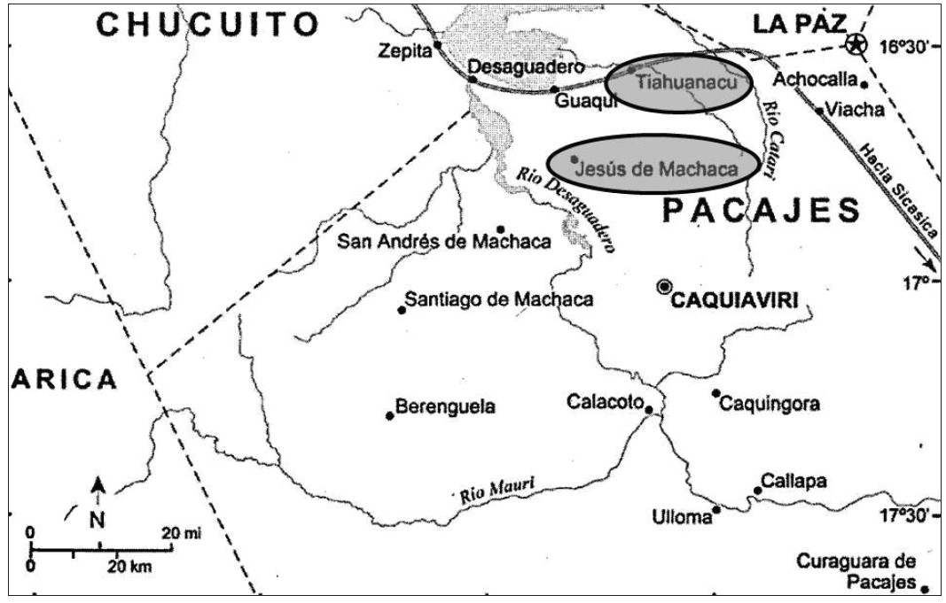
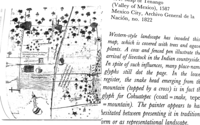
Dispossesions in the Americas

Dispossesions in the Americas

  • Home
  • Explore
  • About
  • Authors
  • Art
  • Bodies
  • Curricula
  • Cultural Heritage
  • Maps
  • Territories
Back to Explore
Map 1550 - 1999

Preconquest and Modern Boundaries of Tarascan Speech

  • RALPH L BEALS

Published: 1969

  • Download Image

Peoples

  • TARASCAN

Citation

Beals, Ralph L. "The Tarascans." In Ethnology, edited by Robert Wauchope and Evon Z. Vogt, 725. Vols. 7-8 of Handbook of Middle American Indians. Austin: University of Texas Press, 1969. https://ebookcentral-proquest-com.proxy.library.upenn.edu/lib/upenn-ebooks/reader.action?docID=4826335&ppg=746.

  • Download Image

Reading in Spanish

Map 1550 - 1999

Preconquest and Modern Boundaries of Tarascan Speech

  • RALPH L BEALS

Published: 1969

  • Download Image
  • Download Image

Reading in Portuguese

Map 1550 - 1999

Preconquest and Modern Boundaries of Tarascan Speech

  • RALPH L BEALS

Published: 1969

  • Download Image

Peoples

  • TARASCAN

Citation

Beals, Ralph L. "The Tarascans." In Ethnology, edited by Robert Wauchope and Evon Z. Vogt, 725. Vols. 7-8 of Handbook of Middle American Indians. Austin: University of Texas Press, 1969. https://ebookcentral-proquest-com.proxy.library.upenn.edu/lib/upenn-ebooks/reader.action?docID=4826335&ppg=746.

  • Download Image

Related Content

Victoria regia [Giant Water Lily]

Victoria regia [Giant Water Lily]

Artwork
Provincia multiétnica y cultural

Provincia multiétnica y cultural

Map 2005
LE BRESIL, dont la Coste est posse dée par les portugais et divisée en Quatorze Capitanieries.

LE BRESIL, dont la Coste est posse dée par les portugais et divisée en Quatorze Capitanieries.

Map 1656
MAPA ETNO-HISTÓRICO DO BRASIL E REGIÕES ADJACENTES

MAPA ETNO-HISTÓRICO DO BRASIL E REGIÕES ADJACENTES

Map 1400 - 1944
‘INDIAN ROYAL TOWNS’ (REDUCCIONES) IN THE PACAJES PROVINCE (CORREGIMIENTO) UNDER SPANISH COLONIAL RULE IN THE LATE 16TH CENTURY

‘INDIAN ROYAL TOWNS’ (REDUCCIONES) IN THE PACAJES PROVINCE (CORREGIMIENTO) UNDER SPANISH COLONIAL RULE IN THE LATE 16TH CENTURY

Map 1570 - 1630
Map of Tenango (Valley of Mexico), 1587, Archivo General de la Nación, no. 1822

Map of Tenango (Valley of Mexico), 1587, Archivo General de la Nación, no. 1822

Map 1587
Plan de la Rivière de Kourou et de la mission.

Plan de la Rivière de Kourou et de la mission.

Map 1700 - 1799
Carte de la partie de l'Yucatan concedée aux Anglais: [traités de 1783 et 1786].

Carte de la partie de l'Yucatan concedée aux Anglais: [traités de 1783 et 1786].

Map 1783 - 1786

Dispossessions in the Americas

A project by

University of Pennsylvania

Copyright 2024

With support from

Mellon Foundation

Site design & development

Element 84

Art Credits

Beals, Ralph L. “The Tarascans.” In Ethnology, edited by Robert Wauchope and Evon Z. Vogt, 725. Vols. 7-8 of Handbook of Middle American Indians. Austin: University of Texas Press, 1969. https://ebookcentral-proquest-com.proxy.library.upenn.edu/lib/upenn-ebooks/reader.action?docID=4826335&ppg=746.

Site Pages

  • Home
  • Explore
  • About
  • Authors
  • Art
  • Bodies
  • Curricula
  • Cultural Heritage
  • Maps
  • Territories