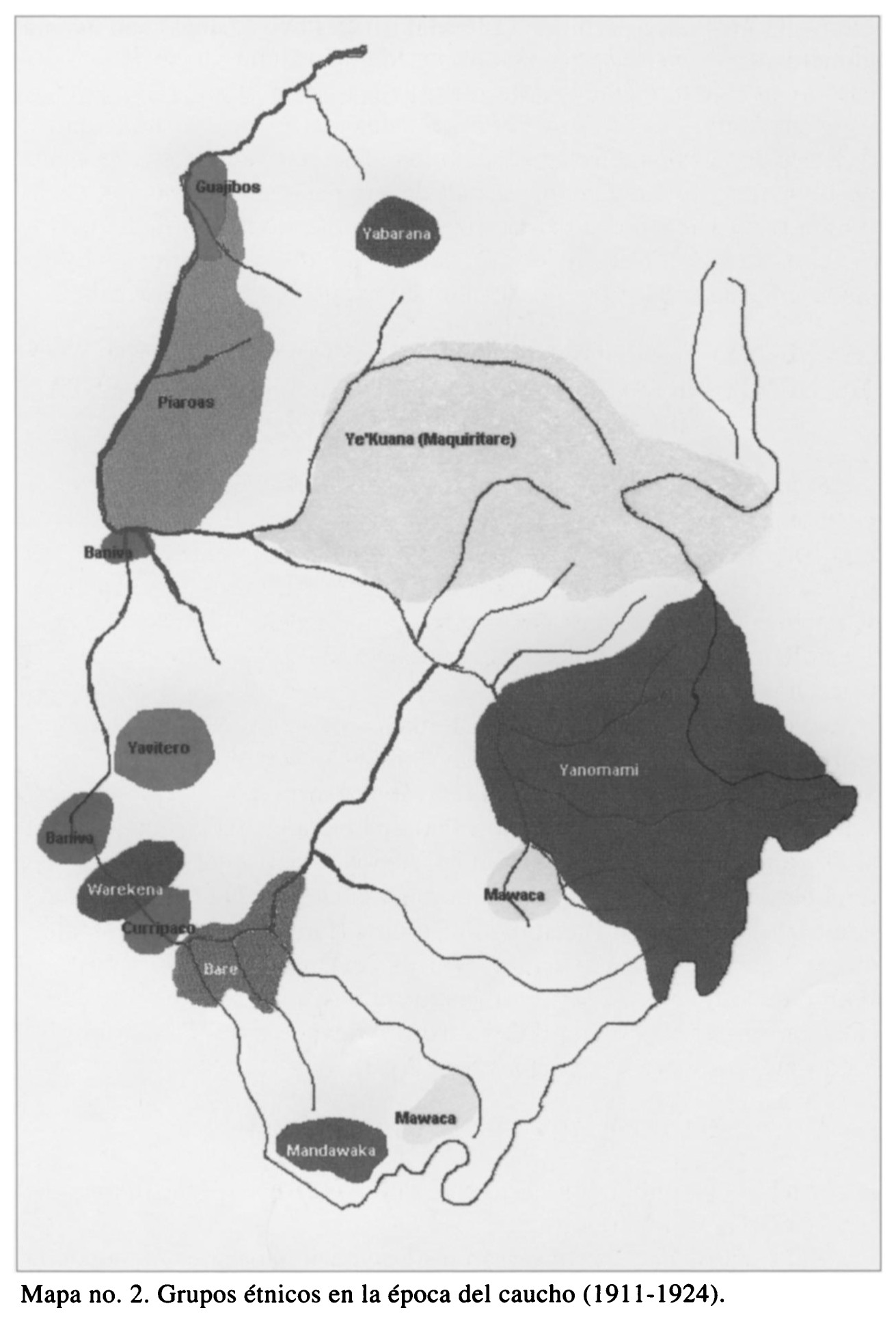
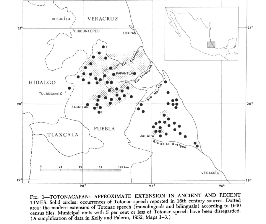
Dispossesions in the Americas

Dispossesions in the Americas

  • Home
  • Explore
  • About
  • Authors
  • Art
  • Bodies
  • Curricula
  • Cultural Heritage
  • Maps
  • Territories
Back to Explore
Map 1940

Totocanapan: Approximate Extension in Ancient and Recent Times

  • HR HARVEY AND ISABEL KELLY

Published: 1969

  • Download Image

Peoples

  • TOTONAC

Citation

Harvey, H. R., and Isabel Kelly. "The Totonac." In Ethnology, edited by Robert Wauchope and Evon Z. Vogt, 638. Vols. 7-8 of Handbook of Middle American Indians. Austin: University of Texas Press, 1969. Accessed August 18, 2021. https://ebookcentral-proquest-com.proxy.library.upenn.edu/lib/upenn-ebooks/reader.action?docID=4826335&ppg=659.

  • Download Image

Reading in Spanish

Map 1940

Totocanapan: Approximate Extension in Ancient and Recent Times

  • HR HARVEY AND ISABEL KELLY

Published: 1969

  • Download Image
  • Download Image

Reading in Portuguese

Map 1940

Totocanapan: Approximate Extension in Ancient and Recent Times

  • HR HARVEY AND ISABEL KELLY

Published: 1969

  • Download Image

Peoples

  • TOTONAC

Citation

Harvey, H. R., and Isabel Kelly. "The Totonac." In Ethnology, edited by Robert Wauchope and Evon Z. Vogt, 638. Vols. 7-8 of Handbook of Middle American Indians. Austin: University of Texas Press, 1969. Accessed August 18, 2021. https://ebookcentral-proquest-com.proxy.library.upenn.edu/lib/upenn-ebooks/reader.action?docID=4826335&ppg=659.

  • Download Image

Related Content

[Plano de la Isla de Cuba con los derroteros de las naves que vienen de Nueva España al Reino que llaman de Bahama el Nuevo y de las que van a Nueva España y Veracruz]

[Plano de la Isla de Cuba con los derroteros de las naves que vienen de Nueva España al Reino que llaman de Bahama el Nuevo y de las que van a Nueva España y Veracruz]

Map 1500 - 1599
PARTIE DE LA COLOMBIE

PARTIE DE LA COLOMBIE

Map 1827
REGIÓN FRONTERA SUR

REGIÓN FRONTERA SUR

Map 2000
Figure 10.1. Map of Ecuador showing the Western Pichincha research region and the site of Palmitopamba.

Figure 10.1. Map of Ecuador showing the Western Pichincha research region and the site of Palmitopamba.

Map -700 - 1534
Isles de Cayenne

Isles de Cayenne

Map 1686
Mapa de la América Central comprendida entre el Golfo Dulce y Cartagena de Indias;por el Norte y entre la Bahía de Fonseca de Panamá por el Sur.

Mapa de la América Central comprendida entre el Golfo Dulce y Cartagena de Indias;por el Norte y entre la Bahía de Fonseca de Panamá por el Sur.

Map 1777
Carte de la Guyane française (2ème édition). Service géographique des colonies. [Feuille 2]

Carte de la Guyane française (2ème édition). Service géographique des colonies. [Feuille 2]

Map 1926
Grupos étnicos en la época del caucho (1911-1924)

Grupos étnicos en la época del caucho (1911-1924)

Map 1911 - 1924

Dispossessions in the Americas

A project by

University of Pennsylvania

Copyright 2024

With support from

Mellon Foundation

Site design & development

Element 84

Art Credits

Harvey, H. R., and Isabel Kelly. “The Totonac.” In Ethnology, edited by Robert Wauchope and Evon Z. Vogt, 638. Vols. 7-8 of Handbook of Middle American Indians. Austin: University of Texas Press, 1969. Accessed August 18, 2021. https://ebookcentral-proquest-com.proxy.library.upenn.edu/lib/upenn-ebooks/reader.action?docID=4826335&ppg=659.

Site Pages

  • Home
  • Explore
  • About
  • Authors
  • Art
  • Bodies
  • Curricula
  • Cultural Heritage
  • Maps
  • Territories