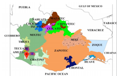
Dispossesions in the Americas

Dispossesions in the Americas

  • Home
  • Explore
  • About
  • Authors
  • Art
  • Bodies
  • Curricula
  • Cultural Heritage
  • Maps
  • Territories
Back to Explore
Map 1969

Distribution of Indian Languages in Central Mexico

  • PEDRO CARRASCO

Published: 1969

  • Download Image

Peoples

  • NAHUATL
  • OTOMI
  • MAZAHUA
  • MATLATZINCA
  • OCUILTECO
  • CHICHIMECA-JONAZ
  • PAME
  • TOTONAC
  • TEPEHUA
  • HUAXTEC
  • TLAPANEC
  • CUITLATEC
  • MIXTEC

Citation

Carrasco, Pedro. "Central Mexican Highlands: Introduction." In Ethnology, edited by Robert Wauchope and Evon Z. Vogt, 579. Vols. 7-8 of Handbook of Middle American Indians. Austin: University of Texas Press, 1969. https://ebookcentral-proquest-com.proxy.library.upenn.edu/lib/upenn-ebooks/reader.action?docID=4826335&ppg=600.

  • Download Image

Reading in Spanish

Map 1969

Distribution of Indian Languages in Central Mexico

  • PEDRO CARRASCO

Published: 1969

  • Download Image
  • Download Image

Reading in Portuguese

Map 1969

Distribution of Indian Languages in Central Mexico

  • PEDRO CARRASCO

Published: 1969

  • Download Image

Peoples

  • NAHUATL
  • OTOMI
  • MAZAHUA
  • MATLATZINCA
  • OCUILTECO
  • CHICHIMECA-JONAZ
  • PAME
  • TOTONAC
  • TEPEHUA
  • HUAXTEC
  • TLAPANEC
  • CUITLATEC
  • MIXTEC

Citation

Carrasco, Pedro. "Central Mexican Highlands: Introduction." In Ethnology, edited by Robert Wauchope and Evon Z. Vogt, 579. Vols. 7-8 of Handbook of Middle American Indians. Austin: University of Texas Press, 1969. https://ebookcentral-proquest-com.proxy.library.upenn.edu/lib/upenn-ebooks/reader.action?docID=4826335&ppg=600.

  • Download Image

Related Content

CARTE DU PARAGUAY et des Pays Voisins

CARTE DU PARAGUAY et des Pays Voisins

Map 1764
[Ecuador & Peru Coastlines] Carta particolare del'Peru che comincia con il capo di Guanapo e finisce con il C. S:

[Ecuador & Peru Coastlines] Carta particolare del'Peru che comincia con il capo di Guanapo e finisce con il C. S:

Map 1646
No Title

No Title

Map 2008
7

7

Artwork
Carte de la Partie de l'Ocean

Carte de la Partie de l'Ocean

Map 1737
PUEBLO LACANDON

PUEBLO LACANDON

Map 2020
Sketch map of part of RÍO ORINOCO and RIO CUCHIVERO from a survey by MAJOR STANLEY PATERSON

Sketch map of part of RÍO ORINOCO and RIO CUCHIVERO from a survey by MAJOR STANLEY PATERSON

Map 1896
Explorations de la Guyane par Henri Coudreau, 1887-89, 1889-91.

Explorations de la Guyane par Henri Coudreau, 1887-89, 1889-91.

Map 1887 - 1891

Dispossessions in the Americas

A project by

University of Pennsylvania

Copyright 2024

With support from

Mellon Foundation

Site design & development

Element 84

Art Credits

Carrasco, Pedro. “Central Mexican Highlands: Introduction.” In Ethnology, edited by Robert Wauchope and Evon Z. Vogt, 579. Vols. 7-8 of Handbook of Middle American Indians. Austin: University of Texas Press, 1969. https://ebookcentral-proquest-com.proxy.library.upenn.edu/lib/upenn-ebooks/reader.action?docID=4826335&ppg=600.

Site Pages

  • Home
  • Explore
  • About
  • Authors
  • Art
  • Bodies
  • Curricula
  • Cultural Heritage
  • Maps
  • Territories