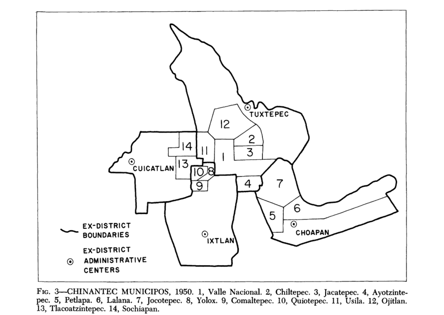
Dispossesions in the Americas

Dispossesions in the Americas

  • Home
  • Explore
  • About
  • Authors
  • Art
  • Bodies
  • Curricula
  • Cultural Heritage
  • Maps
  • Territories
Back to Explore
Map 1950

Chinantec Municipios, 1950

  • ROBERTO J WEITLANER, HOWARD F CLINE

Published: 1969

  • Download Image

Peoples

  • CHINANTEC

Citation

Weitlaner, Roberto J., and Howard F. Cline. "The Chinantec." In Ethnology, edited by Robert Wauchope and Evon Z. Vogt, 523. Vols. 7-8 of Handbook of Middle American Indians. Austin: University of Texas Press, 1969. https://ebookcentral-proquest-com.proxy.library.upenn.edu/lib/upenn-ebooks/reader.action?docID=4826335&ppg=544.

  • Download Image

Reading in Spanish

Map 1950

Chinantec Municipios, 1950

  • ROBERTO J WEITLANER, HOWARD F CLINE

Published: 1969

  • Download Image
  • Download Image

Reading in Portuguese

Map 1950

Chinantec Municipios, 1950

  • ROBERTO J WEITLANER, HOWARD F CLINE

Published: 1969

  • Download Image

Peoples

  • CHINANTEC

Citation

Weitlaner, Roberto J., and Howard F. Cline. "The Chinantec." In Ethnology, edited by Robert Wauchope and Evon Z. Vogt, 523. Vols. 7-8 of Handbook of Middle American Indians. Austin: University of Texas Press, 1969. https://ebookcentral-proquest-com.proxy.library.upenn.edu/lib/upenn-ebooks/reader.action?docID=4826335&ppg=544.

  • Download Image

Related Content

Plano hidrográphico de una parte del Orinoco, que comprende desde el caño de Guaruapo hasta la ysla de Faxardo, por el qual se manifiesta que el sitio más apto para establecer el nuevo fuerte es enfrente del castillo de San Francisco de Assis de la ciudad de Guayana

Plano hidrográphico de una parte del Orinoco, que comprende desde el caño de Guaruapo hasta la ysla de Faxardo, por el qual se manifiesta que el sitio más apto para establecer el nuevo fuerte es enfrente del castillo de San Francisco de Assis de la ciudad de Guayana

Map 1747
Carte particulière de l'Isle et des environs de Cayenne colonie françoise À Paris Chez Desnos, Ingénieur pour les Globes et Sphères.

Carte particulière de l'Isle et des environs de Cayenne colonie françoise À Paris Chez Desnos, Ingénieur pour les Globes et Sphères.

Map 1700 - 1799
Carte de la Guyana pour servir à l'Histoire Generale des Voyages.

Carte de la Guyana pour servir à l'Histoire Generale des Voyages.

Map 1757
La noche, la lora y los muertos [The Night, the Parrot and the Dead]

La noche, la lora y los muertos [The Night, the Parrot and the Dead]

Artwork
INTENDENCIA DE MICHOACÁN

INTENDENCIA DE MICHOACÁN

Map 1800
GUERRERO

GUERRERO

Map 2015
Sin título [Untitled]

Sin título [Untitled]

Artwork
2. THE JIBARO TRIBES

2. THE JIBARO TRIBES

Map 1976 - 1978

Dispossessions in the Americas

A project by

University of Pennsylvania

Copyright 2024

With support from

Mellon Foundation

Site design & development

Element 84

Art Credits

Weitlaner, Roberto J., and Howard F. Cline. “The Chinantec.” In Ethnology, edited by Robert Wauchope and Evon Z. Vogt, 523. Vols. 7-8 of Handbook of Middle American Indians. Austin: University of Texas Press, 1969. https://ebookcentral-proquest-com.proxy.library.upenn.edu/lib/upenn-ebooks/reader.action?docID=4826335&ppg=544.

Site Pages

  • Home
  • Explore
  • About
  • Authors
  • Art
  • Bodies
  • Curricula
  • Cultural Heritage
  • Maps
  • Territories