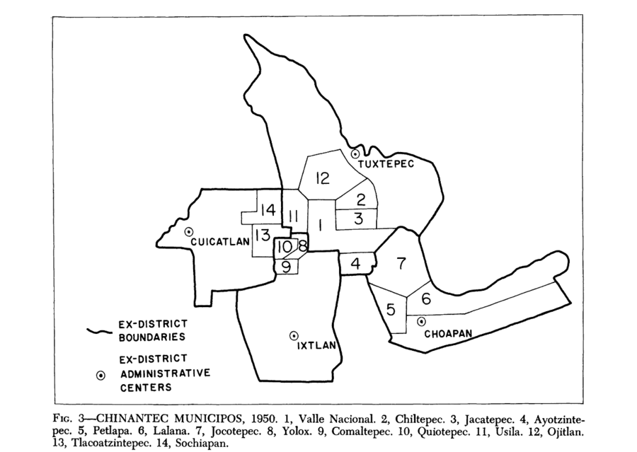
Dispossesions in the Americas

Dispossesions in the Americas

  • Home
  • Explore
  • About
  • Authors
  • Art
  • Bodies
  • Curricula
  • Cultural Heritage
  • Maps
  • Territories
Back to Explore
Map 1950

Chinantec Municipios, 1950

  • ROBERTO J WEITLANER, HOWARD F CLINE

Published: 1969

  • Download Image

Peoples

  • CHINANTEC

Citation

Weitlaner, Roberto J., and Howard F. Cline. "The Chinantec." In Ethnology, edited by Robert Wauchope and Evon Z. Vogt, 523. Vols. 7-8 of Handbook of Middle American Indians. Austin: University of Texas Press, 1969. https://ebookcentral-proquest-com.proxy.library.upenn.edu/lib/upenn-ebooks/reader.action?docID=4826335&ppg=544.

  • Download Image

Reading in Spanish

Map 1950

Chinantec Municipios, 1950

  • ROBERTO J WEITLANER, HOWARD F CLINE

Published: 1969

  • Download Image
  • Download Image

Reading in Portuguese

Map 1950

Chinantec Municipios, 1950

  • ROBERTO J WEITLANER, HOWARD F CLINE

Published: 1969

  • Download Image

Peoples

  • CHINANTEC

Citation

Weitlaner, Roberto J., and Howard F. Cline. "The Chinantec." In Ethnology, edited by Robert Wauchope and Evon Z. Vogt, 523. Vols. 7-8 of Handbook of Middle American Indians. Austin: University of Texas Press, 1969. https://ebookcentral-proquest-com.proxy.library.upenn.edu/lib/upenn-ebooks/reader.action?docID=4826335&ppg=544.

  • Download Image

Related Content

Shipibas vendiendo artesanías en Lima [Shipibas Selling Handicrafts in Lima]

Shipibas vendiendo artesanías en Lima [Shipibas Selling Handicrafts in Lima]

Artwork
Carte de la Guyane Francoise ou France Equinoxiale. Grand, beau et très fertile Pays de l'Amerique Meridionale, située entre la Riviere de Marauny et le Cap Nord

Carte de la Guyane Francoise ou France Equinoxiale. Grand, beau et très fertile Pays de l'Amerique Meridionale, située entre la Riviere de Marauny et le Cap Nord

Map 1763
Izquyluca; Tenayuca. Distrito Federal, 1594

Izquyluca; Tenayuca. Distrito Federal, 1594

Map 1594
No Title

No Title

Map 2014
LOS CACICAZGOS MUISCAS ALRDEDOR DE 1470

LOS CACICAZGOS MUISCAS ALRDEDOR DE 1470

Map 1470
MAPA COMUNITARIA DE INDIGENAS WUANANA

MAPA COMUNITARIA DE INDIGENAS WUANANA

Map 1996
Do Rio Turi ate a entrada do Grao Para

Do Rio Turi ate a entrada do Grao Para

Map 1600 - 1640
The provinces of La Plata, the Banda Oriental del Uruguay and Chile.

The provinces of La Plata, the Banda Oriental del Uruguay and Chile.

Map 1842

Dispossessions in the Americas

A project by

University of Pennsylvania

Copyright 2024

With support from

Mellon Foundation

Site design & development

Element 84

Art Credits

Weitlaner, Roberto J., and Howard F. Cline. “The Chinantec.” In Ethnology, edited by Robert Wauchope and Evon Z. Vogt, 523. Vols. 7-8 of Handbook of Middle American Indians. Austin: University of Texas Press, 1969. https://ebookcentral-proquest-com.proxy.library.upenn.edu/lib/upenn-ebooks/reader.action?docID=4826335&ppg=544.

Site Pages

  • Home
  • Explore
  • About
  • Authors
  • Art
  • Bodies
  • Curricula
  • Cultural Heritage
  • Maps
  • Territories