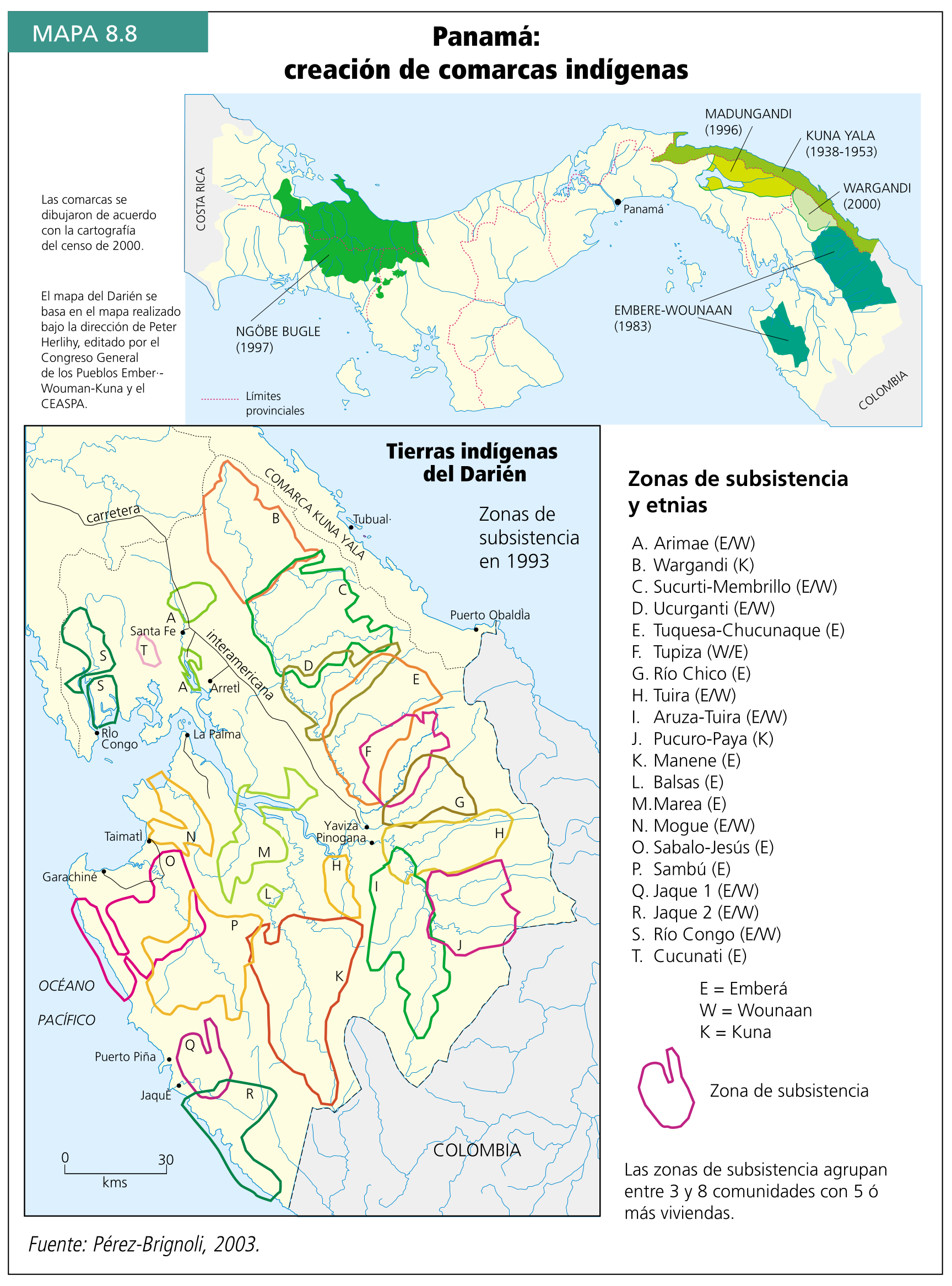
Dispossesions in the Americas

Dispossesions in the Americas

  • Home
  • Explore
  • About
  • Authors
  • Art
  • Bodies
  • Curricula
  • Cultural Heritage
  • Maps
  • Territories
Back to Explore
Map 1969

Mazatec Area

  • ROBERTO J WEITLANER, WALTER A HOPPE

Published: 1969

  • Download Image

Peoples

  • MAZATEC
  • CHINANTEC
  • CUICATEC
  • MIXTEC
  • NAHUA

Citation

Weitlaner, Roberto J., and Walter A. Hoppe. "The Mazatec." In Ethnology, edited by Robert Wauchope and Evon Z. Vogt, 516. Vols. 7-8 of Handbook of Middle American Indians. Austin: University of Texas Press, 1969. https://ebookcentral-proquest-com.proxy.library.upenn.edu/lib/upenn-ebooks/reader.action?docID=4826335&ppg=537.

  • Download Image

Reading in Spanish

Map 1969

Mazatec Area

  • ROBERTO J WEITLANER, WALTER A HOPPE

Published: 1969

  • Download Image
  • Download Image

Related Content

MAPPA da Provincia DE SAN PEDRO

MAPPA da Provincia DE SAN PEDRO

Map 1839
Principal Maya Archaeological Sites

Principal Maya Archaeological Sites

Map 1490
Obispado de Tlaxcala

Obispado de Tlaxcala

Map 1500 - 1599
Corredor del conflicto armado en territorios indígenas de la Costa

Corredor del conflicto armado en territorios indígenas de la Costa

Map 2020
Los quichuas de la Sierra

Los quichuas de la Sierra

Map 1997
An exact draught of the river of Bellese as high as the Barcadares. A new draught of the bay of Honduras by Capt. Nathaniel Uring

An exact draught of the river of Bellese as high as the Barcadares. A new draught of the bay of Honduras by Capt. Nathaniel Uring

Map 1726
Carte Réduite Pour la Navegaton de Cayenne a la Martinique. Dressée au Dépost des Cartes Plans et Journaux de la Marine Pour le Service des Vaisseaux du Roy. Par ordre de M. le Duc des Choiseul Colonel Géneral des Suisses et Grisons;Ministre de la Guerre et de la Marine.

Carte Réduite Pour la Navegaton de Cayenne a la Martinique. Dressée au Dépost des Cartes Plans et Journaux de la Marine Pour le Service des Vaisseaux du Roy. Par ordre de M. le Duc des Choiseul Colonel Géneral des Suisses et Grisons;Ministre de la Guerre et de la Marine.

Map 1700 - 1799
PUEBLO CHOL

PUEBLO CHOL

Map 2020

Dispossessions in the Americas

A project by

University of Pennsylvania

Copyright 2024

With support from

Mellon Foundation

Site design & development

Element 84

Art Credits

Weitlaner, Roberto J., and Walter A. Hoppe. “The Mazatec.” In Ethnology, edited by Robert Wauchope and Evon Z. Vogt, 516. Vols. 7-8 of Handbook of Middle American Indians. Austin: University of Texas Press, 1969. https://ebookcentral-proquest-com.proxy.library.upenn.edu/lib/upenn-ebooks/reader.action?docID=4826335&ppg=537.

Site Pages

  • Home
  • Explore
  • About
  • Authors
  • Art
  • Bodies
  • Curricula
  • Cultural Heritage
  • Maps
  • Territories