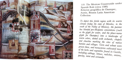
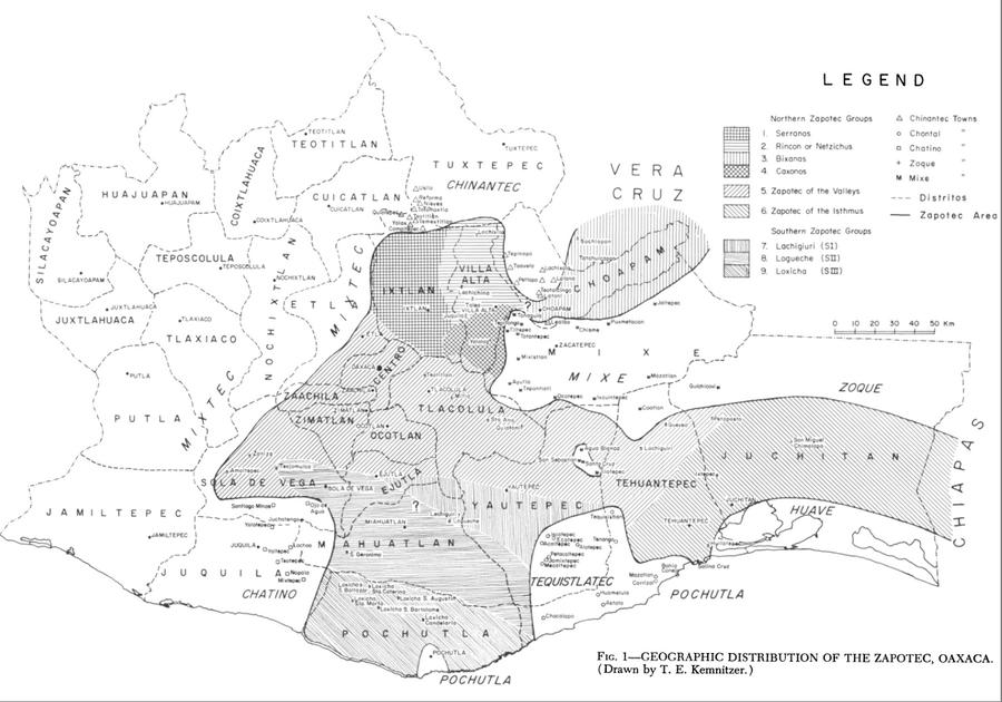
Dispossesions in the Americas

Dispossesions in the Americas

  • Home
  • Explore
  • About
  • Authors
  • Art
  • Bodies
  • Curricula
  • Cultural Heritage
  • Maps
  • Territories
Back to Explore
Map 1969

Geographic Distribution of the Zapotec, Oaxaca

  • LAURA NADER

Published: 1969

  • Download Image

Peoples

  • ZAPOTEC

Citation

Nader, Laura. "The Zapotec of Oaxaca." In Ethnology, edited by Robert Wauchope and Evon Z. Vogt, 329. Vols. 7-8 of Handbook of Middle American Indians. Austin: University of Texas Press, 1969. https://ebookcentral-proquest-com.proxy.library.upenn.edu/lib/upenn-ebooks/reader.action?docID=4826335&ppg=345.

  • Download Image

Reading in Spanish

Map 1969

Geographic Distribution of the Zapotec, Oaxaca

  • LAURA NADER

Published: 1969

  • Download Image
  • Download Image

Related Content

Missiones;quas Provincia Societatis Jesu Paraquarica excolit ad flumina Parana et Urugvay ex natione Guaranica accurate delineatice a quodam ejusdem Missionario Veterano;anno 1744

Missiones;quas Provincia Societatis Jesu Paraquarica excolit ad flumina Parana et Urugvay ex natione Guaranica accurate delineatice a quodam ejusdem Missionario Veterano;anno 1744

Map 1744
Bolivia Pueblos Indígenas

Bolivia Pueblos Indígenas

Map 2020
Misiones de los Indios Andaquiez  : sus navegaciones, y Ríos, naciones, y Caminos desde la Ciudad de Neyva hasta el Pueblo de la Ceja, y de este ála Concepción en el Río Putumayo

Misiones de los Indios Andaquiez : sus navegaciones, y Ríos, naciones, y Caminos desde la Ciudad de Neyva hasta el Pueblo de la Ceja, y de este ála Concepción en el Río Putumayo

Map 1792
BRASILIA ET PERUVIA

BRASILIA ET PERUVIA

Map 1500 - 1599
Carta étnica del Gran Chaco en el umbral del s. XX

Carta étnica del Gran Chaco en el umbral del s. XX

Map 1890 - 1935
LAS TIERRAS DEL SEÑORÍO AYMARA DE LOS CHICHAS DE TALINA BAJO DOMINIO COLONIAL A FINES DEL SIGLO XVI

LAS TIERRAS DEL SEÑORÍO AYMARA DE LOS CHICHAS DE TALINA BAJO DOMINIO COLONIAL A FINES DEL SIGLO XVI

Map 1573 - 1595
Carte de la Partie de l'Ocean

Carte de la Partie de l'Ocean

Map 1737
Partie de la coste de la Guyane depuis la Rivière de Mahury jusqu'à celle de Macouria ou se trouve comprise la Rade de Cayenne

Partie de la coste de la Guyane depuis la Rivière de Mahury jusqu'à celle de Macouria ou se trouve comprise la Rade de Cayenne

Map 1765

Dispossessions in the Americas

A project by

University of Pennsylvania

Copyright 2024

With support from

Mellon Foundation

Site design & development

Element 84

Art Credits

Nader, Laura. “The Zapotec of Oaxaca.” In Ethnology, edited by Robert Wauchope and Evon Z. Vogt, 329. Vols. 7-8 of Handbook of Middle American Indians. Austin: University of Texas Press, 1969. https://ebookcentral-proquest-com.proxy.library.upenn.edu/lib/upenn-ebooks/reader.action?docID=4826335&ppg=345.

Site Pages

  • Home
  • Explore
  • About
  • Authors
  • Art
  • Bodies
  • Curricula
  • Cultural Heritage
  • Maps
  • Territories