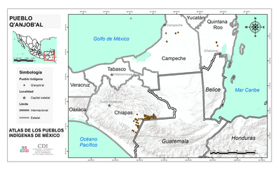
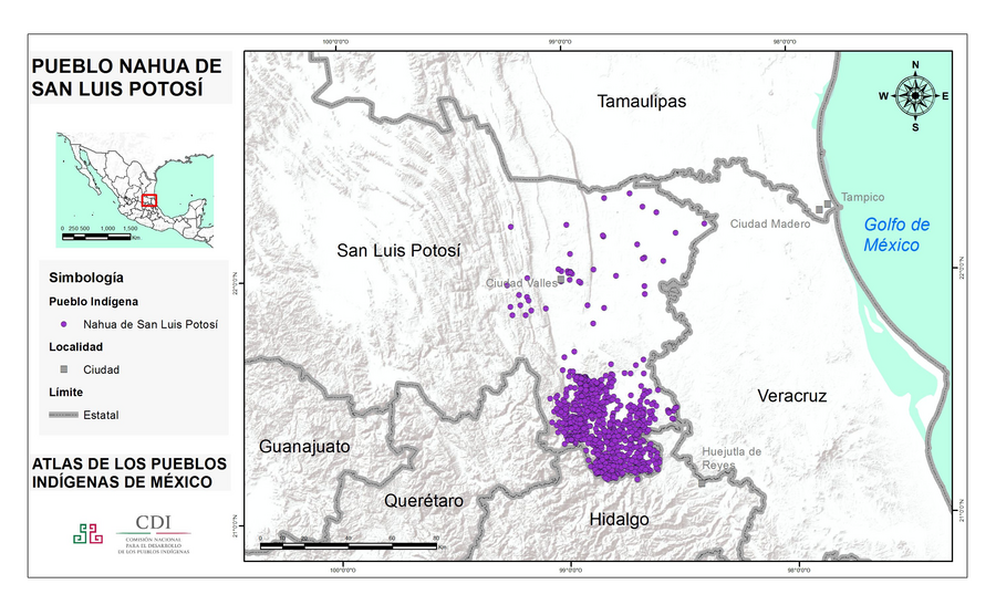
Dispossesions in the Americas

Dispossesions in the Americas

  • Home
  • Explore
  • About
  • Authors
  • Art
  • Bodies
  • Curricula
  • Cultural Heritage
  • Maps
  • Territories
Back to Explore
Map 2020

PUEBLO NAHUA DE SAN LUIS POTOSI

  • INSTITUTO NACIONAL DE LOS PUEBLOS INDIGENAS

Published: 2020

  • Download Image

Peoples

  • NAHUA DE SAN LUIS POTOSI

Citation

Instituto Nacional de los Pueblos Indígenas. "Nahuas de San Luis Potosí – Ubicación." Atlas de los Pueblos Indígenas de México. Accessed August 14, 2021. http://atlas.inpi.gob.mx/nahuas-de-san-luis-potosi-ubicacion/.

  • Download Image

Reading in Spanish

Map 2020

PUEBLO NAHUA DE SAN LUIS POTOSI

  • INSTITUTO NACIONAL DE LOS PUEBLOS INDIGENAS

Published: 2020

  • Download Image
  • Download Image

Reading in Portuguese

Map 2020

PUEBLO NAHUA DE SAN LUIS POTOSI

  • INSTITUTO NACIONAL DE LOS PUEBLOS INDIGENAS

Published: 2020

  • Download Image

Peoples

  • NAHUA DE SAN LUIS POTOSI

Citation

Instituto Nacional de los Pueblos Indígenas. "Nahuas de San Luis Potosí – Ubicación." Atlas de los Pueblos Indígenas de México. Accessed August 14, 2021. http://atlas.inpi.gob.mx/nahuas-de-san-luis-potosi-ubicacion/.

  • Download Image

Related Content

Peru

Peru

Map 1625
Carta particolare dell'India Ocidentale;con la terra ferma dal' capo di Paria sin al' capo S. Romano

Carta particolare dell'India Ocidentale;con la terra ferma dal' capo di Paria sin al' capo S. Romano

Map 1661
THE AYMARA POLITY OF THE LUPAQA: EASTERN INTER-ANDEAN VALLEY COLONIES UNDER INCA RULE 16TH CENTURY

THE AYMARA POLITY OF THE LUPAQA: EASTERN INTER-ANDEAN VALLEY COLONIES UNDER INCA RULE 16TH CENTURY

Map 1560 - 1567
Conquista y Reducción de los Indios Infieles de las Montañas de Paraca y Pantasma en Guatemala

Conquista y Reducción de los Indios Infieles de las Montañas de Paraca y Pantasma en Guatemala

Map 1675 - 1700
Pescaria [Fishing]

Pescaria [Fishing]

Artwork
O Vendedor de frutas [The Fruit Vendor]

O Vendedor de frutas [The Fruit Vendor]

Artwork
[Carte manuscrite de l'Isthme et la Baye de Panama et contrées adjacentes]

[Carte manuscrite de l'Isthme et la Baye de Panama et contrées adjacentes]

Map 1730 - 1760
PUEBLO Q'ANJOB'AL

PUEBLO Q'ANJOB'AL

Map 2020

Dispossessions in the Americas

A project by

University of Pennsylvania

Copyright 2024

With support from

Mellon Foundation

Site design & development

Element 84

Art Credits

Instituto Nacional de los Pueblos Indígenas. “Nahuas de San Luis Potosí – Ubicación.” Atlas de los Pueblos Indígenas de México. Accessed August 14, 2021. http://atlas.inpi.gob.mx/nahuas-de-san-luis-potosi-ubicacion/.

Site Pages

  • Home
  • Explore
  • About
  • Authors
  • Art
  • Bodies
  • Curricula
  • Cultural Heritage
  • Maps
  • Territories