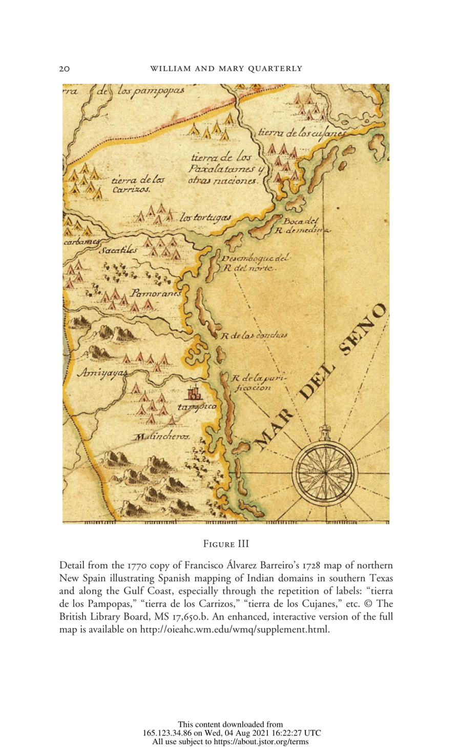
Dispossesions in the Americas

Dispossesions in the Americas

  • Home
  • Explore
  • About
  • Authors
  • Art
  • Bodies
  • Curricula
  • Cultural Heritage
  • Maps
  • Territories
Back to Explore
Map 1728

Detail from the 1770 copy of Francisco Álvarez Barreiro’s 1728 map of northern New Spain illustrating Spanish mapping of Indian domains in southern Texas and along the Gulf Coast, especially through the repetition of labels: “tierra de los Pampopas,” “tierra de los Carrizos,” “tierra de los Cujanes,” etc.

  • FRANCISCO ALVAREZ BARREIRO

Published: 1770

  • Download Image

Peoples

  • CARRIZOS

Citation

Barr, Juliana. "Geographies of Power: Mapping Indian Borders in the 'Borderlands' of the Early Southwest." The William and Mary Quarterly 68, no. 1 January 2011: 5-46. https://www-jstor-org.proxy.library.upenn.edu/stable/10.5309/willmaryquar.68.1.0005#metadata_info_tab_contents.

  • Download Image

Reading in Spanish

Map 1728

Detail from the 1770 copy of Francisco Álvarez Barreiro’s 1728 map of northern New Spain illustrating Spanish mapping of Indian domains in southern Texas and along the Gulf Coast, especially through the repetition of labels: “tierra de los Pampopas,” “tierra de los Carrizos,” “tierra de los Cujanes,” etc.

  • FRANCISCO ALVAREZ BARREIRO

Published: 1770

  • Download Image
  • Download Image

Reading in Portuguese

Map 1728

Detail from the 1770 copy of Francisco Álvarez Barreiro’s 1728 map of northern New Spain illustrating Spanish mapping of Indian domains in southern Texas and along the Gulf Coast, especially through the repetition of labels: “tierra de los Pampopas,” “tierra de los Carrizos,” “tierra de los Cujanes,” etc.

  • FRANCISCO ALVAREZ BARREIRO

Published: 1770

  • Download Image

Peoples

  • CARRIZOS

Citation

Barr, Juliana. "Geographies of Power: Mapping Indian Borders in the 'Borderlands' of the Early Southwest." The William and Mary Quarterly 68, no. 1 January 2011: 5-46. https://www-jstor-org.proxy.library.upenn.edu/stable/10.5309/willmaryquar.68.1.0005#metadata_info_tab_contents.

  • Download Image

Related Content

Cartes de la Guyane. Carte de la Guyane Drançaise. Dressée sur l'ordre de M.e M. E. Picanon Gouverneur.

Cartes de la Guyane. Carte de la Guyane Drançaise. Dressée sur l'ordre de M.e M. E. Picanon Gouverneur.

Map 1907
The Founding of Tenochtitlan-Mexico Codex Mendoza, Pl 1

The Founding of Tenochtitlan-Mexico Codex Mendoza, Pl 1

Map 1541
Mapa de la tierra descubierta de las montañas de los Andes, cerro de la Sal, y ciudad que fundaron los españoles conquistadores, primeros de ella, de la una y otra banda del río Marañón

Mapa de la tierra descubierta de las montañas de los Andes, cerro de la Sal, y ciudad que fundaron los españoles conquistadores, primeros de ella, de la una y otra banda del río Marañón

Map 1663
"Territorio Indígena Brunka de Boruca"

"Territorio Indígena Brunka de Boruca"

Map 2010
TERRITORIO DEL PUEBLO SHUAR ATRUAM

TERRITORIO DEL PUEBLO SHUAR ATRUAM

Map 2017
Tea Farm in Itacolomi

Tea Farm in Itacolomi

Artwork
PUEBLO KU'AHL

PUEBLO KU'AHL

Map 2020
DEMARCACIÓN DE LÍMITES DEL PUEBLO REAL DE INDIOS (REDUCCIÓN) DE TALINA (1573)

DEMARCACIÓN DE LÍMITES DEL PUEBLO REAL DE INDIOS (REDUCCIÓN) DE TALINA (1573)

Map 1573

Dispossessions in the Americas

A project by

University of Pennsylvania

Copyright 2024

With support from

Mellon Foundation

Site design & development

Element 84

Art Credits

Barr, Juliana. “Geographies of Power: Mapping Indian Borders in the ‘Borderlands’ of the Early Southwest.” The William and Mary Quarterly 68, no. 1 January 2011: 5-46. https://www-jstor-org.proxy.library.upenn.edu/stable/10.5309/willmaryquar.68.1.0005#metadata_info_tab_contents.

Site Pages

  • Home
  • Explore
  • About
  • Authors
  • Art
  • Bodies
  • Curricula
  • Cultural Heritage
  • Maps
  • Territories