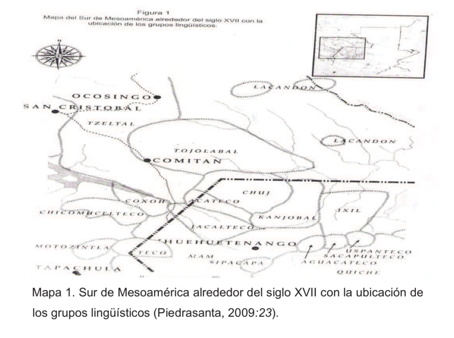
Dispossesions in the Americas

Dispossesions in the Americas

  • Home
  • Explore
  • About
  • Authors
  • Art
  • Bodies
  • Curricula
  • Cultural Heritage
  • Maps
  • Territories
Back to Explore
Map 1800 - 1900

Sur de Mesamérica alrededor del siglo XVII con los grupos lingüísticos

  • PIEDRASANTA

Published: 2009

  • Download Image

Peoples

  • LACANDON
  • TZELTAL
  • TOJOLABAL
  • CHUJ
  • COXOH
  • CHICOMUCELTECO
  • MOTOCINTLA
  • TECO
  • JACALTECO
  • ACATECO
  • QANJOBAL
  • IXIL
  • MAM
  • SIPACAPA
  • USPANTECO
  • SACAPULTECO
  • AGUACATECO
  • QUICHE

Citation

López Rivas, Griselda. "Conocimientos culturales y educación formal entre los chuj. Bases para una educación intercultural." Master's thesis, Colegio del Frontera Sur, 2016. Accessed April 30, 2021. http://aleph.ecosur.mx:8991/exlibris/aleph/a22_1/apache_media/S21BC9YUCTSQFAD72CCBC8USPCKFJI.pdf.

  • Download Image

Reading in Spanish

Map 1800 - 1900

Sur de Mesamérica alrededor del siglo XVII con los grupos lingüísticos

  • PIEDRASANTA

Published: 2009

  • Download Image
  • Download Image

Reading in Portuguese

Map 1800 - 1900

Sur de Mesamérica alrededor del siglo XVII con los grupos lingüísticos

  • PIEDRASANTA

Published: 2009

  • Download Image

Peoples

  • LACANDON
  • TZELTAL
  • TOJOLABAL
  • CHUJ
  • COXOH
  • CHICOMUCELTECO
  • MOTOCINTLA
  • TECO
  • JACALTECO
  • ACATECO
  • QANJOBAL
  • IXIL
  • MAM
  • SIPACAPA
  • USPANTECO
  • SACAPULTECO
  • AGUACATECO
  • QUICHE

Citation

López Rivas, Griselda. "Conocimientos culturales y educación formal entre los chuj. Bases para una educación intercultural." Master's thesis, Colegio del Frontera Sur, 2016. Accessed April 30, 2021. http://aleph.ecosur.mx:8991/exlibris/aleph/a22_1/apache_media/S21BC9YUCTSQFAD72CCBC8USPCKFJI.pdf.

  • Download Image

Related Content

PUEBLO ARABELA

PUEBLO ARABELA

Map 2021
A Map of BRASIL and Part of LA PLATA

A Map of BRASIL and Part of LA PLATA

Map 1717
Guaraní en Argentina 2016, Pueblos Guaraníes en América del Sur 2016

Guaraní en Argentina 2016, Pueblos Guaraníes en América del Sur 2016

Map 2016
Esquisse géologique de la Guyane française [Feuille Nord]

Esquisse géologique de la Guyane française [Feuille Nord]

Map 1949
Chile: Desierto de Atacama

Chile: Desierto de Atacama

Map 1854
CARTA GEOGRÁFICA DEL ECUADOR POR DR. TEODORO WOLF;PUBLICADA POR ORDEN DEL SUPREMO GOBIERNO DE LA REPÚBLICA Y TRABAJADA BAJO LAS PRESIDENCIAS DE LOS EE. SEÑORES DR. D.J.M. PLÁCIDO CAAMAÑO Y DR. D. ANTONIO FLORES. 1892 ... INSTITUTO GEOGRAFICO DE H. WAGNER & E. DEBES EN LEIPZIG. (WITH) LA REGION ORIENTAL DEL ECUADOR. (WITH) ARCHIPIÉLAGO DE GALÁPAGOS.

CARTA GEOGRÁFICA DEL ECUADOR POR DR. TEODORO WOLF;PUBLICADA POR ORDEN DEL SUPREMO GOBIERNO DE LA REPÚBLICA Y TRABAJADA BAJO LAS PRESIDENCIAS DE LOS EE. SEÑORES DR. D.J.M. PLÁCIDO CAAMAÑO Y DR. D. ANTONIO FLORES. 1892 ... INSTITUTO GEOGRAFICO DE H. WAGNER & E. DEBES EN LEIPZIG. (WITH) LA REGION ORIENTAL DEL ECUADOR. (WITH) ARCHIPIÉLAGO DE GALÁPAGOS.

Map 1892
COAST OF GUYANA FROM THE OROONOKO TO THE RIVER OF AMAZONS AND THE INLAND PARTS AS FAR AS THEY HAVE BEEN EXPLORED BY THE FRENCH & DUTCH ENGINEERS WITH THE ISLANDS OF BARBADOS TOBAGO & CA.

COAST OF GUYANA FROM THE OROONOKO TO THE RIVER OF AMAZONS AND THE INLAND PARTS AS FAR AS THEY HAVE BEEN EXPLORED BY THE FRENCH & DUTCH ENGINEERS WITH THE ISLANDS OF BARBADOS TOBAGO & CA.

Map 1781
SOUTH AMERICAN STATES. NEW GRANADA & VENEZUELA.

SOUTH AMERICAN STATES. NEW GRANADA & VENEZUELA.

Map 1872

Dispossessions in the Americas

A project by

University of Pennsylvania

Copyright 2024

With support from

Mellon Foundation

Site design & development

Element 84

Art Credits

López Rivas, Griselda. “Conocimientos culturales y educación formal entre los chuj. Bases para una educación intercultural.” Master’s thesis, Colegio del Frontera Sur, 2016. Accessed April 30, 2021. http://aleph.ecosur.mx:8991/exlibris/aleph/a22_1/apache_media/S21BC9YUCTSQFAD72CCBC8USPCKFJI.pdf.

Site Pages

  • Home
  • Explore
  • About
  • Authors
  • Art
  • Bodies
  • Curricula
  • Cultural Heritage
  • Maps
  • Territories