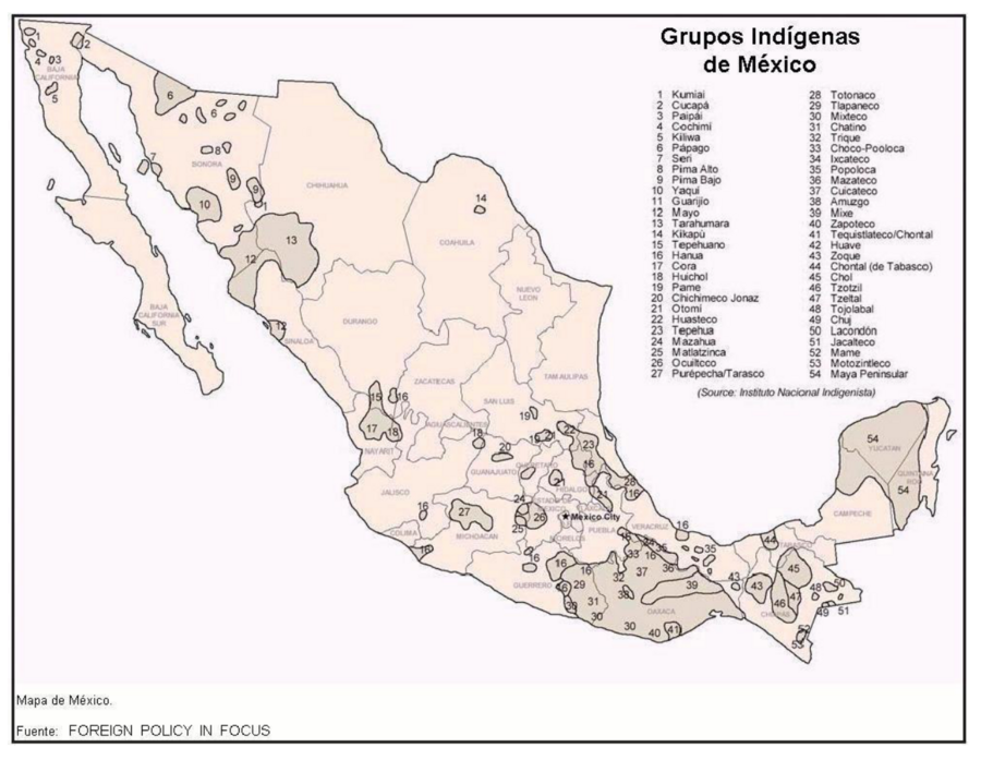
Dispossesions in the Americas

Dispossesions in the Americas

  • Home
  • Explore
  • About
  • Authors
  • Art
  • Bodies
  • Curricula
  • Cultural Heritage
  • Maps
  • Territories
Back to Explore
Map 2001

Grupos Indígenas de México

  • SILVEL ELIAS

Published: 2001

  • Download Image

Peoples

  • KUMIAI
  • CUCAPA
  • PAIPAI
  • COCHIMI
  • KILIWA
  • PAPAGO
  • SERI
  • PIMA ALTO
  • PIMA BAJO
  • YAQUI
  • GUARIJIO
  • MAYO
  • TARAHUMARA
  • KIKAPU
  • TEPEHUANO
  • HANUA
  • CORA
  • HUICHOL
  • PAME
  • CHICHIMECO JONAZ
  • OTOMI
  • HUASTECO
  • TEPEHUA
  • MAZAHUA
  • MATLATZINCA
  • OCUILTECO
  • PUREPECHA
  • TARASCO
  • TOTONACO
  • TLAPANECO
  • MIXTECO
  • CHATINO
  • TRIQUE
  • CHOCO-POPOLOCA
  • IXCATECO
  • POPOLOCA
  • IXCATECO
  • MAZATECO
  • CUICATECO
  • AUZGO
  • MIXE
  • ZAPOTECO
  • TEQUISLALTECO
  • CHONTAL
  • HUAVE
  • ZOQUE
  • CHONTAL DE TABASCO
  • CHOL
  • TZOTZIL
  • TZELTAL
  • TOJOLABAL
  • CHUJ
  • LACANDON
  • JACALTECO
  • MAME
  • MOTOZINTLECO
  • MAYA PENINSULAR

Citation

Elías, Silvel. "Territorios y áreas conservadas por pueblos indígenas y comunidades locales TICCA: raíces y evolución histórica, amenazas y oportunidades actuales y posible estrategia de reconocimiento y fortalecimiento en Mesoamérica." Working paper, 2001. https://www.iccaconsortium.org/wp-content/uploads/2016/03/TICCA_Mesoamerica_Selias-first-draft-es.pdf.

  • Download Image

Reading in Spanish

Map 2001

Grupos Indígenas de México

  • SILVEL ELIAS

Published: 2001

  • Download Image
  • Download Image

Related Content

Honduran municipios with highest percentage of each ethnic group, 2001

Honduran municipios with highest percentage of each ethnic group, 2001

Map 2001
Pueblo y tierras de Sopó

Pueblo y tierras de Sopó

Map 1758
Distribution of Tarascan Speech by Settlements, 1940

Distribution of Tarascan Speech by Settlements, 1940

Map 1940
Indians in Cuba

Indians in Cuba

Map 1989
LE BRESIL, dont la Coste est posse dée par les portugais et divisée en Quatorze Capitanieries.

LE BRESIL, dont la Coste est posse dée par les portugais et divisée en Quatorze Capitanieries.

Map 1656
Cited Toldería Locations, 1750-1806

Cited Toldería Locations, 1750-1806

Map 1750 - 1806
PUEBLO HUICHOL

PUEBLO HUICHOL

Map 2020
MAPA DEL ANTIGUO REINO DE GUATEMALA EN LA EPOCA DE SU DESCUBRIMIENTO Y CONQUISTA

MAPA DEL ANTIGUO REINO DE GUATEMALA EN LA EPOCA DE SU DESCUBRIMIENTO Y CONQUISTA

Map 1900 - 1999

Dispossessions in the Americas

A project by

University of Pennsylvania

Copyright 2024

With support from

Mellon Foundation

Site design & development

Element 84

Art Credits

Elías, Silvel. “Territorios y áreas conservadas por pueblos indígenas y comunidades locales TICCA: raíces y evolución histórica, amenazas y oportunidades actuales y posible estrategia de reconocimiento y fortalecimiento en Mesoamérica.” Working paper, 2001. https://www.iccaconsortium.org/wp-content/uploads/2016/03/TICCA_Mesoamerica_Selias-first-draft-es.pdf.

Site Pages

  • Home
  • Explore
  • About
  • Authors
  • Art
  • Bodies
  • Curricula
  • Cultural Heritage
  • Maps
  • Territories