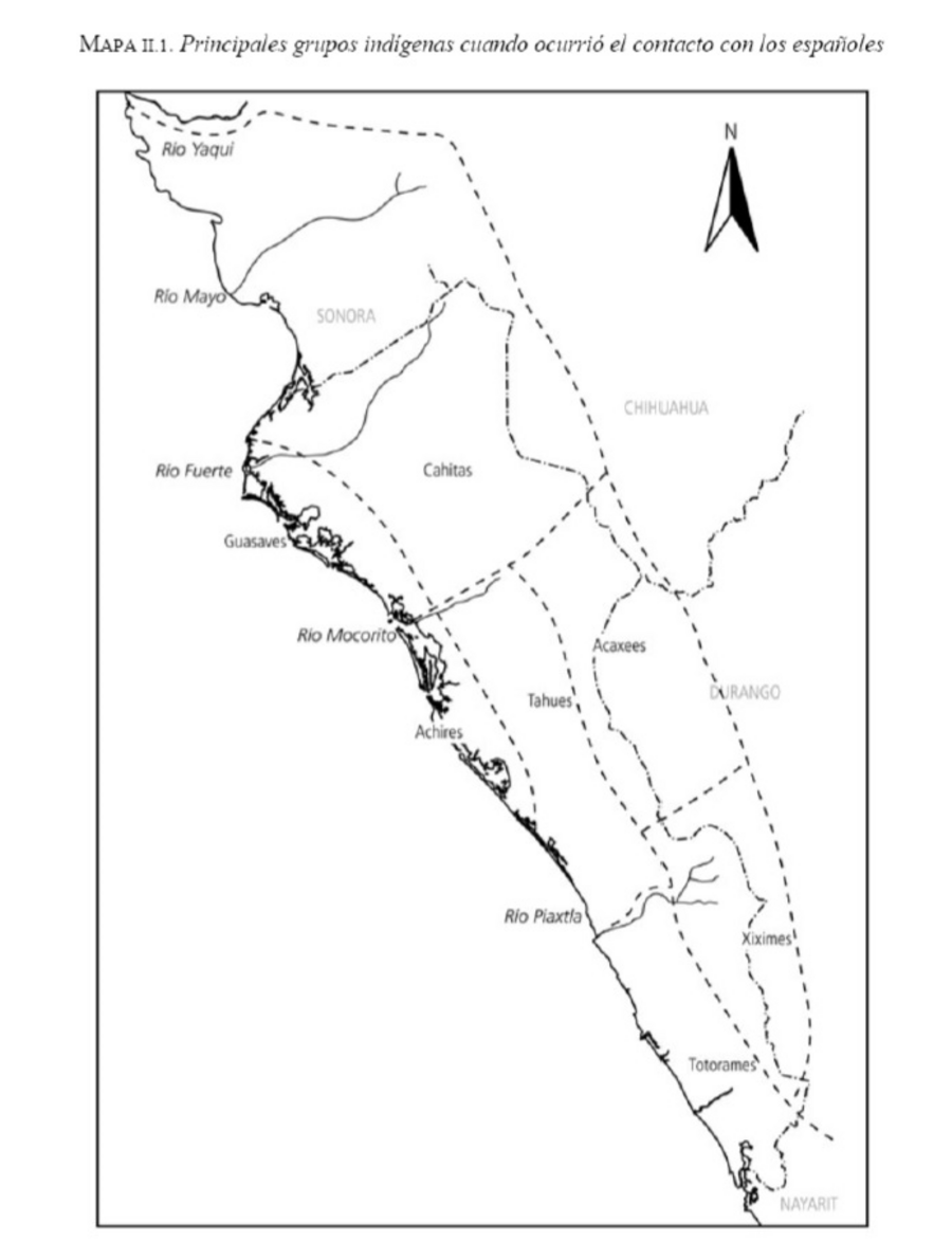
Dispossesions in the Americas

Dispossesions in the Americas

  • Home
  • Explore
  • About
  • Authors
  • Art
  • Bodies
  • Curricula
  • Cultural Heritage
  • Maps
  • Territories
Back to Explore
Map 1530

Principales grupos indígenas cuando ocurrió el contacto con los españoles

  • SERGIO ORTEGA NORIEGA

Published: 2016

  • Download Image

Peoples

  • CAHITAS
  • GUASAVES
  • ACHIRES
  • TAHUES
  • ACAXEES
  • XIXIMES
  • TOTORAMES

Citation

Ortega Noriega, Sergio. Sinaloa: Historia breve. Edited by Alicia Hernández Chávez and Yavana Celaya Nández. Historias breves. Ciudad de México: Fondo de Cultura Económica, 2016. https://proxy.library.upenn.edu/login?url=https://search.ebscohost.com/login.aspx?direct=true&db=nlebk&AN=1721911&site=ehost-live.

  • Download Image

Reading in Spanish

Map 1530

Principales grupos indígenas cuando ocurrió el contacto con los españoles

  • SERGIO ORTEGA NORIEGA

Published: 2016

  • Download Image
  • Download Image

Reading in Portuguese

Map 1530

Principales grupos indígenas cuando ocurrió el contacto con los españoles

  • SERGIO ORTEGA NORIEGA

Published: 2016

  • Download Image

Peoples

  • CAHITAS
  • GUASAVES
  • ACHIRES
  • TAHUES
  • ACAXEES
  • XIXIMES
  • TOTORAMES

Citation

Ortega Noriega, Sergio. Sinaloa: Historia breve. Edited by Alicia Hernández Chávez and Yavana Celaya Nández. Historias breves. Ciudad de México: Fondo de Cultura Económica, 2016. https://proxy.library.upenn.edu/login?url=https://search.ebscohost.com/login.aspx?direct=true&db=nlebk&AN=1721911&site=ehost-live.

  • Download Image

Related Content

ISLE DE SAINT SÉBASTIEN a la Coste du Brésil

ISLE DE SAINT SÉBASTIEN a la Coste du Brésil

Map 1764
FAMILIAS LINGUÍSTICAS Y LENGUAS INDÍGENAS. SEPTIMA REGION: SIERRA NEVADA DE SANTA MARTA

FAMILIAS LINGUÍSTICAS Y LENGUAS INDÍGENAS. SEPTIMA REGION: SIERRA NEVADA DE SANTA MARTA

Map 1989
Bosquejo hodométrico del expacio que media entre los extremos de la Provincia de Suchiltepeques y la Capital de Guatemala, para dar una idea del nuevo camino abierto y costeado por D. José Rossi y Rubí, Alcalde mayor de dicha Provincia, de orden superior, año de 1800.

Bosquejo hodométrico del expacio que media entre los extremos de la Provincia de Suchiltepeques y la Capital de Guatemala, para dar una idea del nuevo camino abierto y costeado por D. José Rossi y Rubí, Alcalde mayor de dicha Provincia, de orden superior, año de 1800.

Map 1800
"Carta Maritima del Reyno de Tierra Firme ú Castilla del Oro : Comprehende el Istmo y Provincia de Panamá, las Provincias de Veragua, Darien y Biruquete"

"Carta Maritima del Reyno de Tierra Firme ú Castilla del Oro : Comprehende el Istmo y Provincia de Panamá, las Provincias de Veragua, Darien y Biruquete"

Map 1729 - 1776
MIDWEST HIGHLANDS OF GUATEMALA, POPULATION ESTIMATES AS OF 1937

MIDWEST HIGHLANDS OF GUATEMALA, POPULATION ESTIMATES AS OF 1937

Map 1937
PUEBLO YINE

PUEBLO YINE

Map 2021
Location of the main settlements on the Lenca-Chortí-Nahua-Pipil frontier, 1530-1539. (Taken from Lara-Pinto 2009 with modifications.)

Location of the main settlements on the Lenca-Chortí-Nahua-Pipil frontier, 1530-1539. (Taken from Lara-Pinto 2009 with modifications.)

Map 1530 - 1539
Una de las Postales Mentía [One of the Postcards Lied]

Una de las Postales Mentía [One of the Postcards Lied]

Artwork

Dispossessions in the Americas

A project by

University of Pennsylvania

Copyright 2024

With support from

Mellon Foundation

Site design & development

Element 84

Art Credits

Ortega Noriega, Sergio. Sinaloa: Historia breve. Edited by Alicia Hernández Chávez and Yavana Celaya Nández. Historias breves. Ciudad de México: Fondo de Cultura Económica, 2016. https://proxy.library.upenn.edu/login?url=https://search.ebscohost.com/login.aspx?direct=true&db=nlebk&AN=1721911&site=ehost-live.

Site Pages

  • Home
  • Explore
  • About
  • Authors
  • Art
  • Bodies
  • Curricula
  • Cultural Heritage
  • Maps
  • Territories