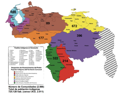
Dispossesions in the Americas

Dispossesions in the Americas

  • Home
  • Explore
  • About
  • Authors
  • Art
  • Bodies
  • Curricula
  • Cultural Heritage
  • Maps
  • Territories
Back to Explore
Map 1500 - 1599

Jamaican Taíno Village of Maima, St. Ann’s Bay, Jamaica

  • BURLEY, DAVID, ET AL

Published: 2017

  • Download Image

Peoples

  • TAINO VILLAGE OF MAIMA

Citation

Burley, David V., Robyn P. Woodward, Shea Henry, and Ivor C. Conolley. "Jamaican Taíno Settlement Configuration at the Time of Christopher Columbus." Latin American Antiquity 28, no. 3. 2017. : 337-52. https://doi.org/10.1017/laq.2017.14.

  • Download Image

Reading in Spanish

Map 1500 - 1599

Jamaican Taíno Village of Maima, St. Ann’s Bay, Jamaica

  • BURLEY, DAVID, ET AL

Published: 2017

  • Download Image
  • Download Image

Reading in Portuguese

Map 1500 - 1599

Jamaican Taíno Village of Maima, St. Ann’s Bay, Jamaica

  • BURLEY, DAVID, ET AL

Published: 2017

  • Download Image

Peoples

  • TAINO VILLAGE OF MAIMA

Citation

Burley, David V., Robyn P. Woodward, Shea Henry, and Ivor C. Conolley. "Jamaican Taíno Settlement Configuration at the Time of Christopher Columbus." Latin American Antiquity 28, no. 3. 2017. : 337-52. https://doi.org/10.1017/laq.2017.14.

  • Download Image

Related Content

Blue Creek

Blue Creek

Map 1997
Mapa De Las Lenguas Indigenas Actuales De Guatemala, Compilado Por A. Goubaud Carrera Y A. Arriaga;Seminario De Integracion Social

Mapa De Las Lenguas Indigenas Actuales De Guatemala, Compilado Por A. Goubaud Carrera Y A. Arriaga;Seminario De Integracion Social

Map 1964
Lamento Kayapó [Kayapó Lament]

Lamento Kayapó [Kayapó Lament]

Artwork
CARTA GEOGRÁFICA DEL ECUADOR POR DR. TEODORO WOLF;PUBLICADA POR ORDEN DEL SUPREMO GOBIERNO DE LA REPÚBLICA Y TRABAJADA BAJO LAS PRESIDENCIAS DE LOS EE. SEÑORES DR. D.J.M. PLÁCIDO CAAMAÑO Y DR. D. ANTONIO FLORES. 1892 ... INSTITUTO GEOGRAFICO DE H. WAGNER & E. DEBES EN LEIPZIG. (WITH) LA REGION ORIENTAL DEL ECUADOR. (WITH) ARCHIPIÉLAGO DE GALÁPAGOS.

CARTA GEOGRÁFICA DEL ECUADOR POR DR. TEODORO WOLF;PUBLICADA POR ORDEN DEL SUPREMO GOBIERNO DE LA REPÚBLICA Y TRABAJADA BAJO LAS PRESIDENCIAS DE LOS EE. SEÑORES DR. D.J.M. PLÁCIDO CAAMAÑO Y DR. D. ANTONIO FLORES. 1892 ... INSTITUTO GEOGRAFICO DE H. WAGNER & E. DEBES EN LEIPZIG. (WITH) LA REGION ORIENTAL DEL ECUADOR. (WITH) ARCHIPIÉLAGO DE GALÁPAGOS.

Map 1892
Mapa por despacho de Vice-ministerios

Mapa por despacho de Vice-ministerios

Map 2012
Plano del pueblo de Nuestra Señora de Altagracia y del reparto de tierras a los indios, con vista de Cumaná y de la fortaleza de Araya.

Plano del pueblo de Nuestra Señora de Altagracia y del reparto de tierras a los indios, con vista de Cumaná y de la fortaleza de Araya.

Map 1704
Terra Indígena Bananal (Peruíbe)

Terra Indígena Bananal (Peruíbe)

Map 2011
MAPA DE LOCALIZACIÓN DE NACIONALIDADES Y PUEBLOS INDÍGENAS DEL ECUADOR

MAPA DE LOCALIZACIÓN DE NACIONALIDADES Y PUEBLOS INDÍGENAS DEL ECUADOR

Map 2010

Dispossessions in the Americas

A project by

University of Pennsylvania

Copyright 2024

With support from

Mellon Foundation

Site design & development

Element 84

Art Credits

Burley, David V., Robyn P. Woodward, Shea Henry, and Ivor C. Conolley. “Jamaican Taíno Settlement Configuration at the Time of Christopher Columbus.” Latin American Antiquity 28, no. 3. 2017. : 337-52. https://doi.org/10.1017/laq.2017.14.

Site Pages

  • Home
  • Explore
  • About
  • Authors
  • Art
  • Bodies
  • Curricula
  • Cultural Heritage
  • Maps
  • Territories