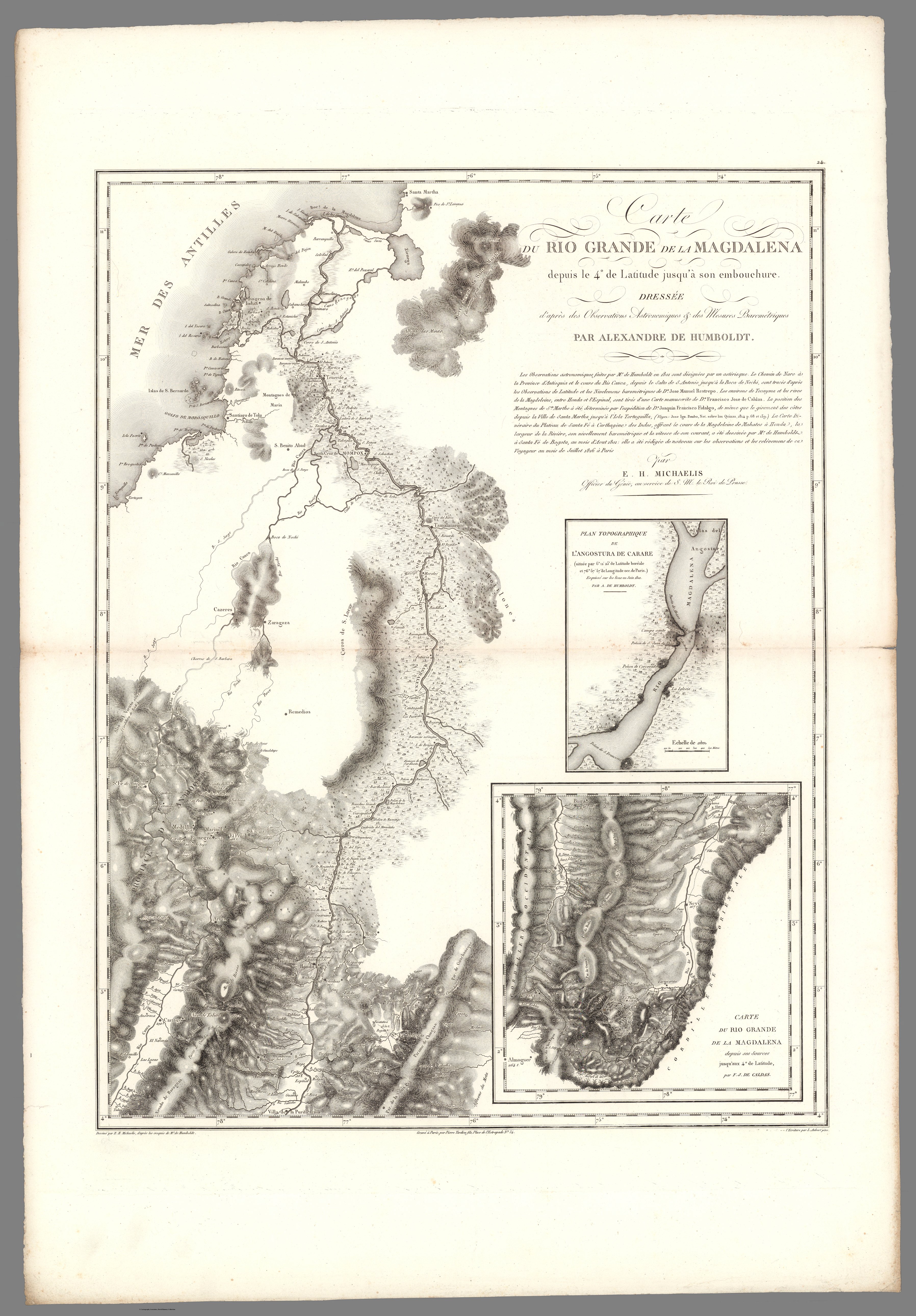
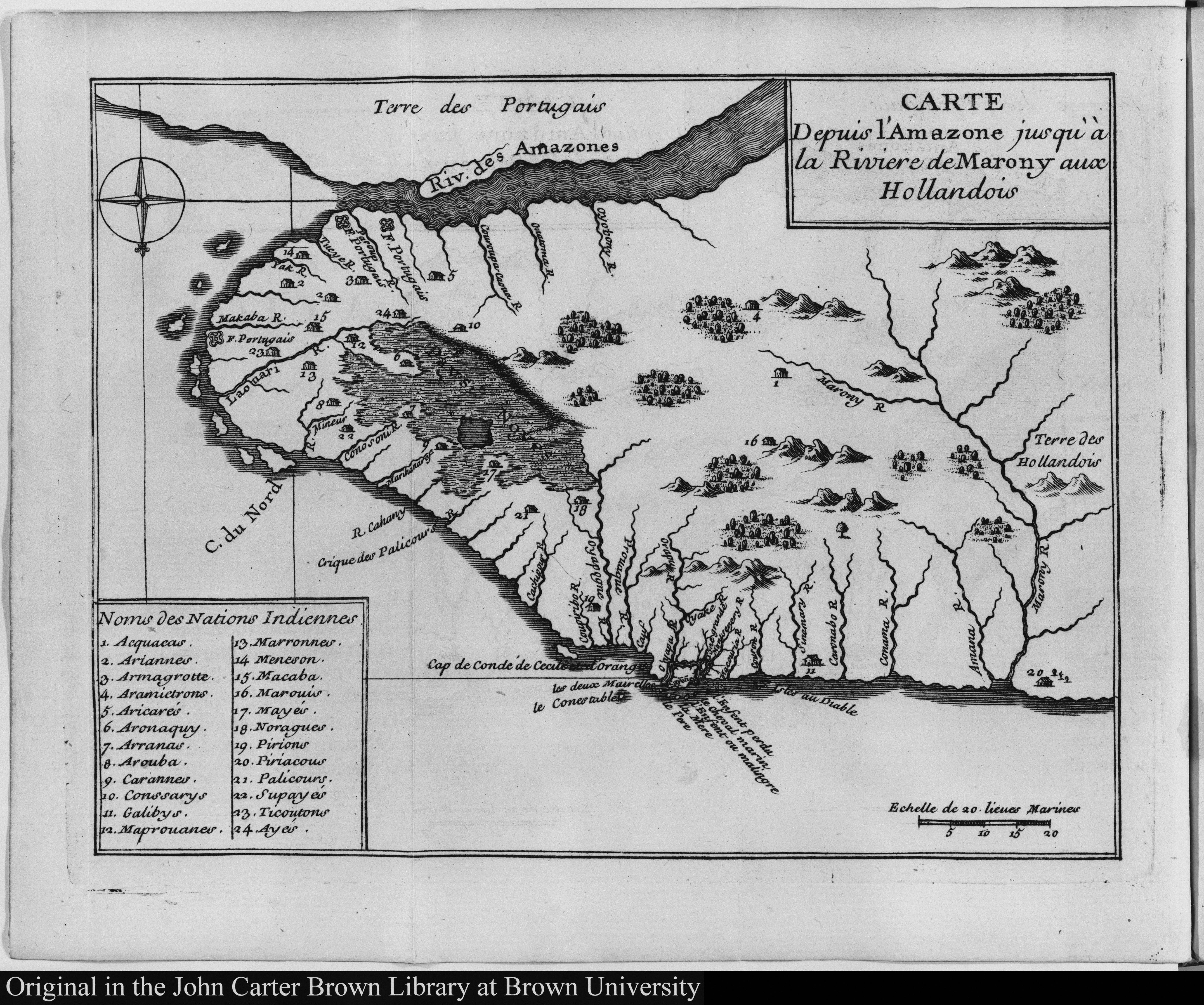
Dispossesions in the Americas

Dispossesions in the Americas

  • Home
  • Explore
  • About
  • Authors
  • Art
  • Bodies
  • Curricula
  • Cultural Heritage
  • Maps
  • Territories
Back to Explore
Map 1735

The Spanish and Musketor shore and the bay of Honduras and the islands adjacent

  • PENHALLOW, SAMUEL

Published: 1735

  • Download Image

Peoples

  • MUSKETOR

Citation

Penhallow, Samuel. The Spanish and Musketor shore and the bay of Honduras and the islands adjacent. Map. London, England, 1735. Accessed August 6, 2023. https://gallica.bnf.fr/ark:/12148/btv1b5970790d/f1.item.r=Honduras.zoom.

  • Download Image

Reading in Spanish

Map 1735

The Spanish and Musketor shore and the bay of Honduras and the islands adjacent

  • PENHALLOW, SAMUEL

Published: 1735

  • Download Image
  • Download Image

Related Content

MAPA 1 LÍMITES GEOGRAFICOS DE LA LÍNEA NEGRA

MAPA 1 LÍMITES GEOGRAFICOS DE LA LÍNEA NEGRA

Map 2018
PUEBLO Q'EQCHI'

PUEBLO Q'EQCHI'

Map 2020
PUEBLO SHARANAHUA

PUEBLO SHARANAHUA

Map 2021
Explorations de la Guyane par Henri Coudreau, 1887-89, 1889-91.

Explorations de la Guyane par Henri Coudreau, 1887-89, 1889-91.

Map 1887 - 1891
Coste de Guayane autrement France equinoctiale en la Terre Ferme d'Amérique.

Coste de Guayane autrement France equinoctiale en la Terre Ferme d'Amérique.

Map 1677
TITLED INDIGENOUS TERRITORIES (TIOCs)  IN THE BOLIVIAN INTER-ANDEAN VALLEYS BY 2011

TITLED INDIGENOUS TERRITORIES (TIOCs) IN THE BOLIVIAN INTER-ANDEAN VALLEYS BY 2011

Map 2011
Carte du Pérou, ou se trouvent les Audiences de Quito, Lima et la Plata projettée et assujettie aux observations astronomiques

Carte du Pérou, ou se trouvent les Audiences de Quito, Lima et la Plata projettée et assujettie aux observations astronomiques

Map 1771
NLE. GRENADE;VENEZUELA;EQUATEUR;GUYANES.

NLE. GRENADE;VENEZUELA;EQUATEUR;GUYANES.

Map 1860

Dispossessions in the Americas

A project by

University of Pennsylvania

Copyright 2024

With support from

Mellon Foundation

Site design & development

Element 84

Art Credits

Penhallow, Samuel. The Spanish and Musketor shore and the bay of Honduras and the islands adjacent. Map. London, England, 1735. Accessed August 6, 2023. https://gallica.bnf.fr/ark:/12148/btv1b5970790d/f1.item.r=Honduras.zoom.

Site Pages

  • Home
  • Explore
  • About
  • Authors
  • Art
  • Bodies
  • Curricula
  • Cultural Heritage
  • Maps
  • Territories