Dispossesions in the Americas

Dispossesions in the Americas

  • Home
  • Explore
  • About
  • Authors
  • Art
  • Bodies
  • Curricula
  • Cultural Heritage
  • Maps
  • Territories
Back to Explore
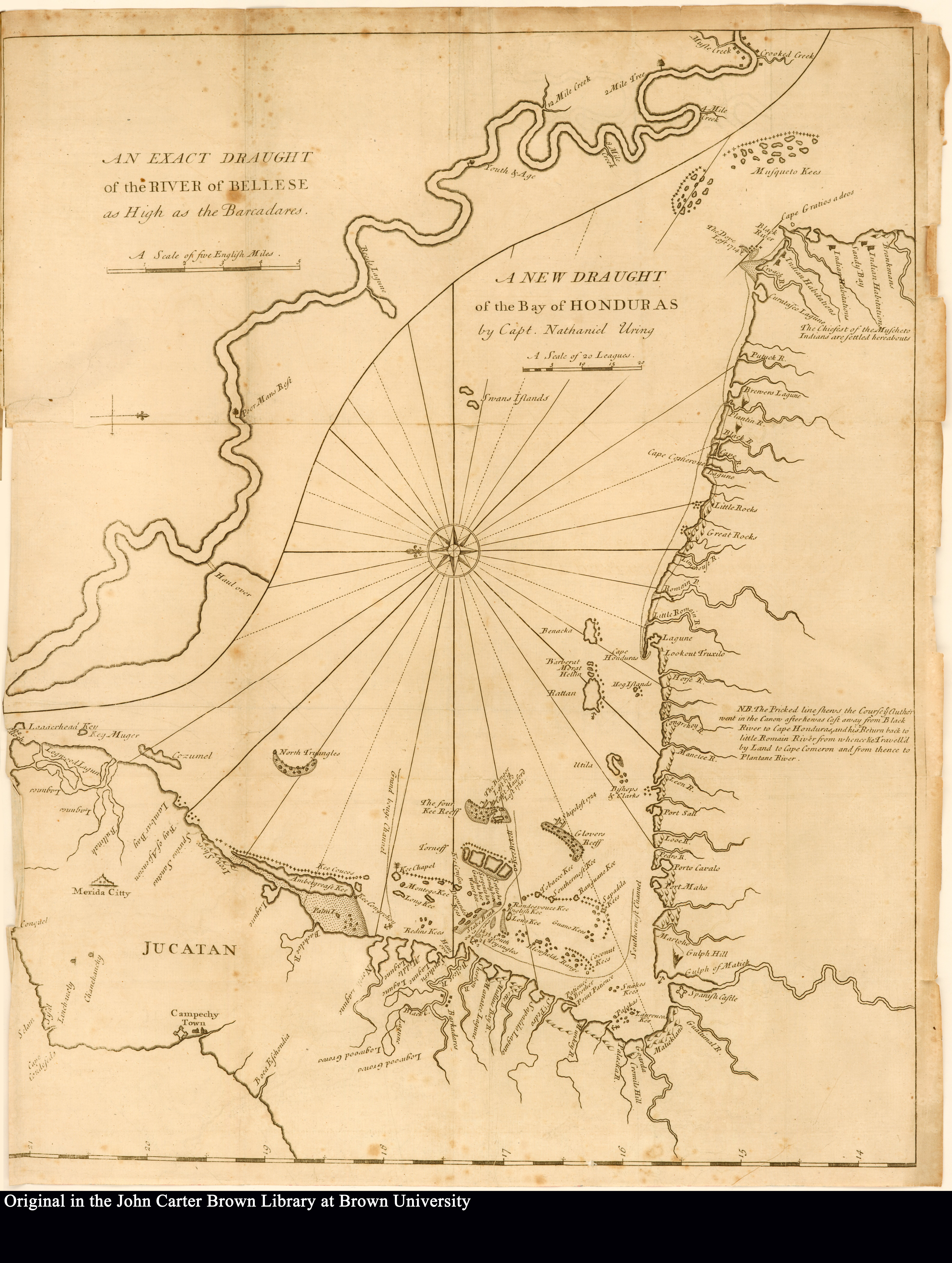
Map 1726

An exact draught of the river of Bellese as high as the Barcadares. A new draught of the bay of Honduras by Capt. Nathaniel Uring

  • URING, NATHANIEL

Published: 1726

  • Download Image

Peoples

  • MUSCHETO

Citation

Uring, Nathaniel. An exact draught of the river of Bellese as high as the Barcadares. A new draught of the bay of Honduras by Capt. Nathaniel Uring. Map. London, England: W. Wilkins, 1726. Accessed July 14, 2023. https://jcb.lunaimaging.com/luna/servlet/detail/JCBMAPS~1~1~4799~102886:An-exact-draught-of-the-river-of-Be?sort=normalized_date%2Cfile_name%2Csource_author%2Csource_title&qvq=q:an%20exact%20draught%20of%20the%20river;sort:normalized_date%2Cfile_name%2Csource_author%2Csource_title;lc:JCBMAPS~1~1&mi=1&trs=3.
  • Download Image

Reading in Spanish

Map 1726

An exact draught of the river of Bellese as high as the Barcadares. A new draught of the bay of Honduras by Capt. Nathaniel Uring

  • URING, NATHANIEL

Published: 1726

  • Download Image
  • Download Image

Related Content

Indian Riots and Rebellions in Guatemala, 1679-1825

Indian Riots and Rebellions in Guatemala, 1679-1825

Map 1679 - 1825
Santa Teresa

Santa Teresa

Map 1997
[Carte manuscrite de l'embouchure de Rio da Prata]

[Carte manuscrite de l'embouchure de Rio da Prata]

Map 1740
Karte von BRITISCH ~ GUYANA;nebst dem Quelllande des Prima (Rio Branco) und Orinoco

Karte von BRITISCH ~ GUYANA;nebst dem Quelllande des Prima (Rio Branco) und Orinoco

Map 1835 - 1844
Plano del territorio de la Pampa y Río Negro, y de las once provincias chilenas que lo avecindan por el oeste

Plano del territorio de la Pampa y Río Negro, y de las once provincias chilenas que lo avecindan por el oeste

Map 1880
REGIÓN NORTE DE CHIAPAS

REGIÓN NORTE DE CHIAPAS

Map 2000
PUEBLOS QUECHUAS

PUEBLOS QUECHUAS

Map 2021
No Title

No Title

Map 1777

Dispossessions in the Americas

A project by

University of Pennsylvania

Copyright 2024

With support from

Mellon Foundation

Site design & development

Element 84

Art Credits

Uring, Nathaniel. An exact draught of the river of Bellese as high as the Barcadares. A new draught of the bay of Honduras by Capt. Nathaniel Uring. Map. London, England: W. Wilkins, 1726. Accessed July 14, 2023. https://jcb.lunaimaging.com/luna/servlet/detail/JCBMAPS~1~1~4799~102886:An-exact-draught-of-the-river-of-Be?sort=normalized_date%2Cfile_name%2Csource_author%2Csource_title&qvq=q:an%20exact%20draught%20of%20the%20river;sort:normalized_date%2Cfile_name%2Csource_author%2Csource_title;lc:JCBMAPS~1~1&mi=1&trs=3.
Site Pages

  • Home
  • Explore
  • About
  • Authors
  • Art
  • Bodies
  • Curricula
  • Cultural Heritage
  • Maps
  • Territories