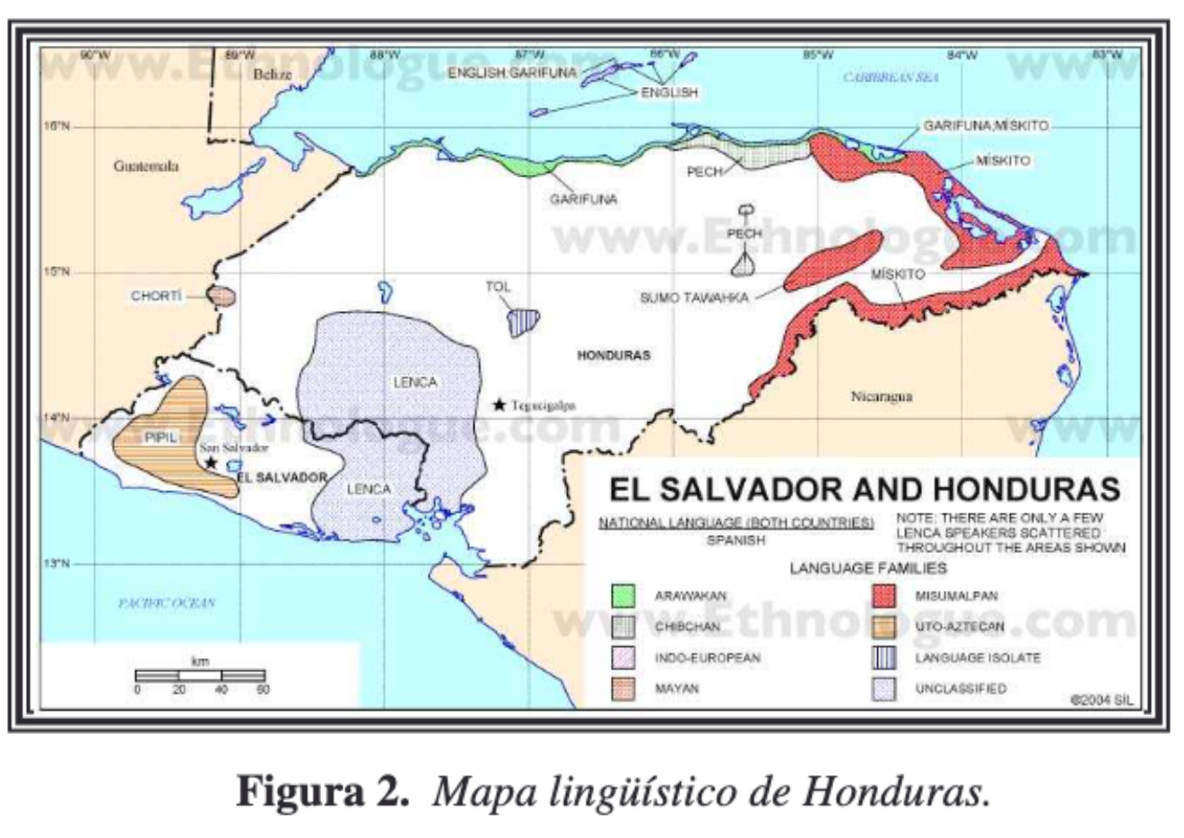
Dispossesions in the Americas

Dispossesions in the Americas

  • Home
  • Explore
  • About
  • Authors
  • Art
  • Bodies
  • Curricula
  • Cultural Heritage
  • Maps
  • Territories
Back to Explore
Map 2004

Mapa linguístico de Honduras

    Published: 2004

    • Download Image

    Peoples

    • CHORTI
    • NAHUAPIPIL
    • LENCA
    • TOL
    • GARIFUNA
    • SUMOTAWAHKA
    • PECH
    • MISKITO

    Citation

    UNESCO. "UNESCO - PROGRAMA HIDROLOGICO INTERNACIONAL (PHI) PARA AMERICA LATINA Y EL CARIBE PROYECTO 'CULTURA DEL AGUA' FICHA PARA EL RELEVAMIENTO DE INFORMACIÓN." N.d. PDF. https://docplayer.es/6931456-Unesco-programa-hidrologico-internacional-phi-para-america-latina-y-el-caribe-proyecto-cultura-del-agua-ficha-para-el-relevamiento-de-informacion.html

    • Download Image

    Reading in Spanish

    Map 2004

    Mapa linguístico de Honduras

      Published: 2004

      • Download Image
      • Download Image

      Reading in Portuguese

      Map 2004

      Mapa linguístico de Honduras

        Published: 2004

        • Download Image

        Peoples

        • CHORTI
        • NAHUAPIPIL
        • LENCA
        • TOL
        • GARIFUNA
        • SUMOTAWAHKA
        • PECH
        • MISKITO

        Citation

        UNESCO. "UNESCO - PROGRAMA HIDROLOGICO INTERNACIONAL (PHI) PARA AMERICA LATINA Y EL CARIBE PROYECTO 'CULTURA DEL AGUA' FICHA PARA EL RELEVAMIENTO DE INFORMACIÓN." N.d. PDF. https://docplayer.es/6931456-Unesco-programa-hidrologico-internacional-phi-para-america-latina-y-el-caribe-proyecto-cultura-del-agua-ficha-para-el-relevamiento-de-informacion.html

        • Download Image

        Related Content

        Vereinigte Provinzen am LA PLATA Oberperu und Paraguay

        Vereinigte Provinzen am LA PLATA Oberperu und Paraguay

        Map 1826
        TLAXCALA

        TLAXCALA

        Map 2015
        "Descripción del Valle de Chimo y planisphérica de la Ciudad de Truxillo del Perú".

        "Descripción del Valle de Chimo y planisphérica de la Ciudad de Truxillo del Perú".

        Map 1760
        Mapa de la República de Guatemala

        Mapa de la República de Guatemala

        Map 1800 - 1900
        Collection of different versions of the Peru Jaguar, Peru Otorongo, and the “Perucitos”

        Collection of different versions of the Peru Jaguar, Peru Otorongo, and the “Perucitos”

        Artwork
        Location of the main settlements on the Lenca-Chortí-Nahua-Pipil frontier, 1530-1539. (Taken from Lara-Pinto 2009 with modifications.)

        Location of the main settlements on the Lenca-Chortí-Nahua-Pipil frontier, 1530-1539. (Taken from Lara-Pinto 2009 with modifications.)

        Map 1530 - 1539
        Carta inédita de la extremidad austral de América construída por el P. José Cardiel, S. J. en 1747

        Carta inédita de la extremidad austral de América construída por el P. José Cardiel, S. J. en 1747

        Map 1700 - 1750
        PARAGUAY

        PARAGUAY

        Map 1885

        Dispossessions in the Americas

        A project by

        University of Pennsylvania

        Copyright 2024

        With support from

        Mellon Foundation

        Site design & development

        Element 84

        Art Credits

        UNESCO. “UNESCO - PROGRAMA HIDROLOGICO INTERNACIONAL (PHI) PARA AMERICA LATINA Y EL CARIBE PROYECTO ‘CULTURA DEL AGUA’ FICHA PARA EL RELEVAMIENTO DE INFORMACIÓN.” N.d. PDF. https://docplayer.es/6931456-Unesco-programa-hidrologico-internacional-phi-para-america-latina-y-el-caribe-proyecto-cultura-del-agua-ficha-para-el-relevamiento-de-informacion.html

        Site Pages

        • Home
        • Explore
        • About
        • Authors
        • Art
        • Bodies
        • Curricula
        • Cultural Heritage
        • Maps
        • Territories