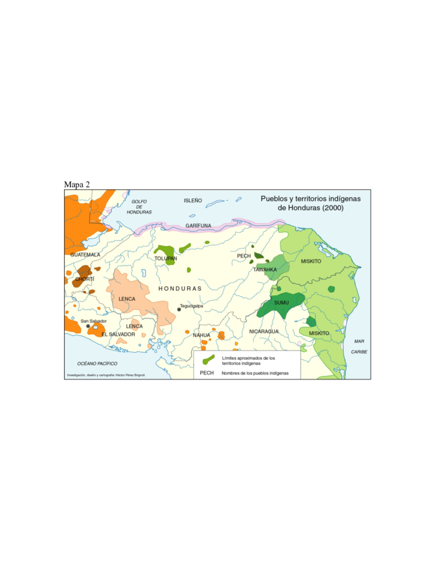
Dispossesions in the Americas

Dispossesions in the Americas

  • Home
  • Explore
  • About
  • Authors
  • Art
  • Bodies
  • Curricula
  • Cultural Heritage
  • Maps
  • Territories
Back to Explore
Map 2000

Pueblos y territorios indígenas de Honduras (2000)

  • HECTOR PEREZ BRIGNOLI

Published: 2005

  • Download Image

Peoples

  • GARIFUNA
  • CHORTI
  • LENCA
  • TOLUPAN
  • NAHUAPIPIL
  • PECH
  • TAWAHKA
  • MAYANGNA
  • MISKITO

Citation

Pérez Brignoli, Héctor. "La dinámica demográfica de las poblaciones indígenas del trópico húmedo en América Central (censos del 2000)." Paper presented at International Union for the Scientific Study of Population XXVth International Population Conference, Tours, France, July 21, 2005. Accessed July 16, 2021. https://iussp2005.princeton.edu/papers/51583.

  • Download Image

Reading in Spanish

Map 2000

Pueblos y territorios indígenas de Honduras (2000)

  • HECTOR PEREZ BRIGNOLI

Published: 2005

  • Download Image
  • Download Image

Related Content

Mapa Guaraní Continental

Mapa Guaraní Continental

Map 2016
Copia del Plano Topográfico de la Ciudad de Lima, capital del Perú, y de su presidio y puerto del Callao, que como última observación de Latitud Austral, y demarcación geográfica de las costas de Chile y del Perú

Copia del Plano Topográfico de la Ciudad de Lima, capital del Perú, y de su presidio y puerto del Callao, que como última observación de Latitud Austral, y demarcación geográfica de las costas de Chile y del Perú

Map 1712
QUINTANA ROO

QUINTANA ROO

Map 2015
PARAGUAY UND DER NÖRDLICHE THEIL DER ARGENTINISCHEN REPUBLIK

PARAGUAY UND DER NÖRDLICHE THEIL DER ARGENTINISCHEN REPUBLIK

Map 1853 - 56
Carte du Nouveau Royaume de Grenade;de la Nouvelle Andalousie;et de la Guyane;avec les Pays limitrophes qui en sont au Sud

Carte du Nouveau Royaume de Grenade;de la Nouvelle Andalousie;et de la Guyane;avec les Pays limitrophes qui en sont au Sud

Map 1770
‘INDIAN ROYAL TOWNS’ (REDUCCIONES) AND PROVINCES (CORREGIMIENTOS) UNDER SPANISH COLONIAL RULE IN THE LATE 16TH CENTURY

‘INDIAN ROYAL TOWNS’ (REDUCCIONES) AND PROVINCES (CORREGIMIENTOS) UNDER SPANISH COLONIAL RULE IN THE LATE 16TH CENTURY

Map 1570 - 1650
RESGUARDOS Y TERRITORIOS INDIGENAS EN COLOMBIA

RESGUARDOS Y TERRITORIOS INDIGENAS EN COLOMBIA

Map 2015
A Description of the Plantations in the Valley of Paneca

A Description of the Plantations in the Valley of Paneca

Map

Dispossessions in the Americas

A project by

University of Pennsylvania

Copyright 2024

With support from

Mellon Foundation

Site design & development

Element 84

Art Credits

Pérez Brignoli, Héctor. “La dinámica demográfica de las poblaciones indígenas del trópico húmedo en América Central (censos del 2000).” Paper presented at International Union for the Scientific Study of Population XXVth International Population Conference, Tours, France, July 21, 2005. Accessed July 16, 2021. https://iussp2005.princeton.edu/papers/51583.

Site Pages

  • Home
  • Explore
  • About
  • Authors
  • Art
  • Bodies
  • Curricula
  • Cultural Heritage
  • Maps
  • Territories