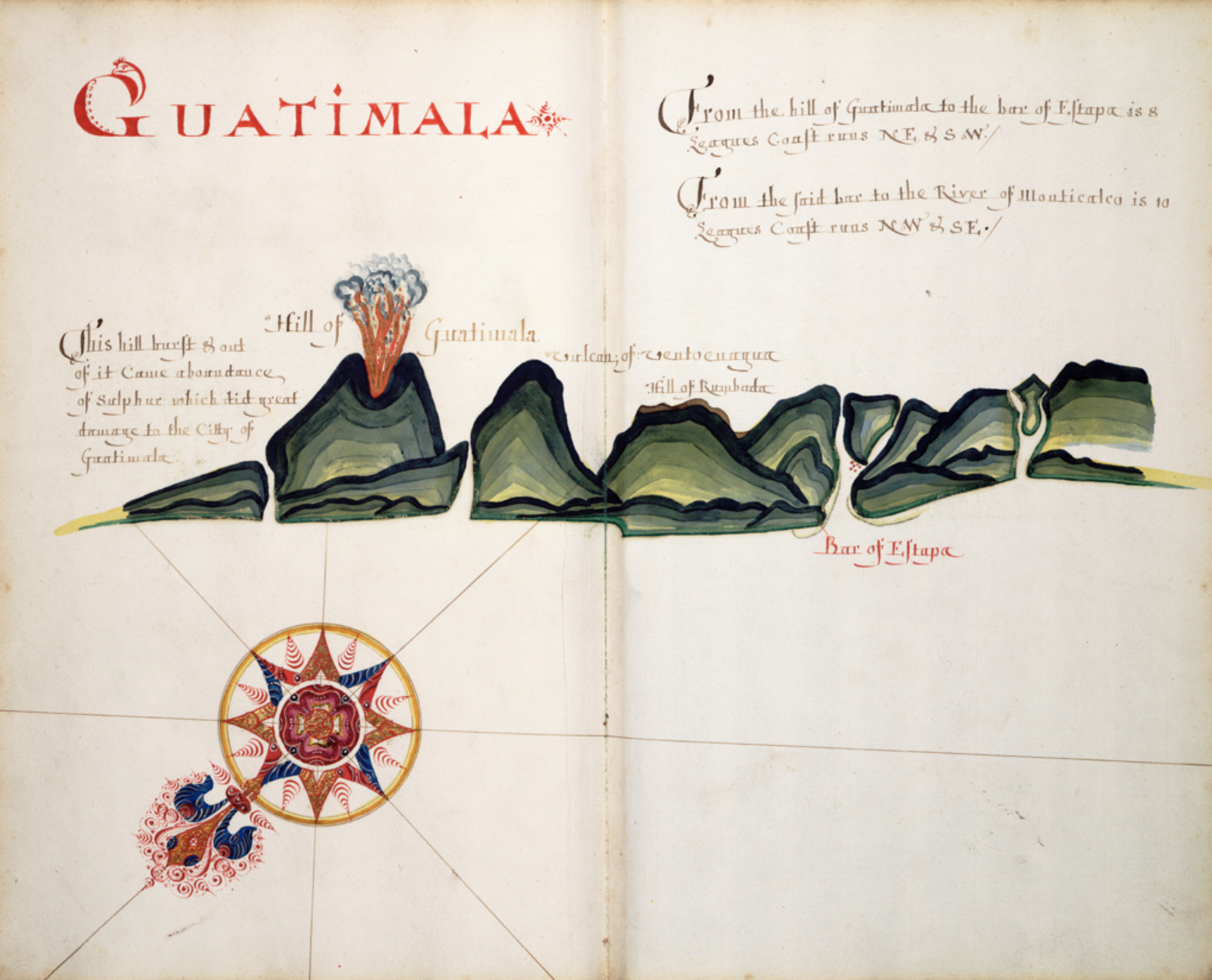
Dispossesions in the Americas

Dispossesions in the Americas

  • Home
  • Explore
  • About
  • Authors
  • Art
  • Bodies
  • Curricula
  • Cultural Heritage
  • Maps
  • Territories
Back to Explore
Map 1680 - 1685

Guatimala

  • HACK, WILLIAM

Published: 1685

  • Download Image

Citation

Hack, William. "Guatimala"A Waggoner of the South Sea describing the sea coast from Acapulco to Albermarle Isle, made by William Hack at the signe of great Britaine and Ireland in Wapping, 1685. National Maritime Museum, Greenwich, London. P/33(19) https://www.rmg.co.uk/collections/objects/rmgc-object-541208

  • Download Image

Reading in Spanish

Map 1680 - 1685

Guatimala

  • HACK, WILLIAM

Published: 1685

  • Download Image
  • Download Image

Reading in Portuguese

Map 1680 - 1685

Guatimala

  • HACK, WILLIAM

Published: 1685

  • Download Image

Citation

Hack, William. "Guatimala"A Waggoner of the South Sea describing the sea coast from Acapulco to Albermarle Isle, made by William Hack at the signe of great Britaine and Ireland in Wapping, 1685. National Maritime Museum, Greenwich, London. P/33(19) https://www.rmg.co.uk/collections/objects/rmgc-object-541208

  • Download Image

Related Content

Mapa geográfico de América meridional.

Mapa geográfico de América meridional.

Map 1755
SOUTH AMERICA Sheet I: ECUADOR;GRANADA;VENEZUELA;AND PARTS OF BRAZIL AND GUYANA

SOUTH AMERICA Sheet I: ECUADOR;GRANADA;VENEZUELA;AND PARTS OF BRAZIL AND GUYANA

Map 1842
REGIÓN VALLES CENTRALES

REGIÓN VALLES CENTRALES

Map 2000
CARTA COROGRÁFICA DE JALISCO, ZACATECAS Y COLIMA

CARTA COROGRÁFICA DE JALISCO, ZACATECAS Y COLIMA

Map 1824
Carte de la Partie Orientale de la Province de Varinas comprise entre L'Orenoque;L'Apure et le Rio Meta

Carte de la Partie Orientale de la Province de Varinas comprise entre L'Orenoque;L'Apure et le Rio Meta

Map 1800
Carte De L'Amérique Méridionale. Pour l Histoire Générale

Carte De L'Amérique Méridionale. Pour l Histoire Générale

Map 1700 - 1770
Ritxoko / Boneca karajá

Ritxoko / Boneca karajá

Artwork
SPECIAL MAP OF BRITISH GUIANA Illustrating the VENEZUELA-GUIANA BOUNDARY DISPUTE

SPECIAL MAP OF BRITISH GUIANA Illustrating the VENEZUELA-GUIANA BOUNDARY DISPUTE

Map 1898

Dispossessions in the Americas

A project by

University of Pennsylvania

Copyright 2024

With support from

Mellon Foundation

Site design & development

Element 84

Art Credits

Hack, William. “Guatimala"A Waggoner of the South Sea describing the sea coast from Acapulco to Albermarle Isle, made by William Hack at the signe of great Britaine and Ireland in Wapping, 1685. National Maritime Museum, Greenwich, London. P/33(19) https://www.rmg.co.uk/collections/objects/rmgc-object-541208

Site Pages

  • Home
  • Explore
  • About
  • Authors
  • Art
  • Bodies
  • Curricula
  • Cultural Heritage
  • Maps
  • Territories