Dispossesions in the Americas

Dispossesions in the Americas

  • Home
  • Explore
  • About
  • Authors
  • Art
  • Bodies
  • Curricula
  • Cultural Heritage
  • Maps
  • Territories
Back to Explore
Map 2000 - 2100

Protected Natural Areas in the Maya Region

  • Harri Kettunen

Published: 2020

  • Download Image

Citation

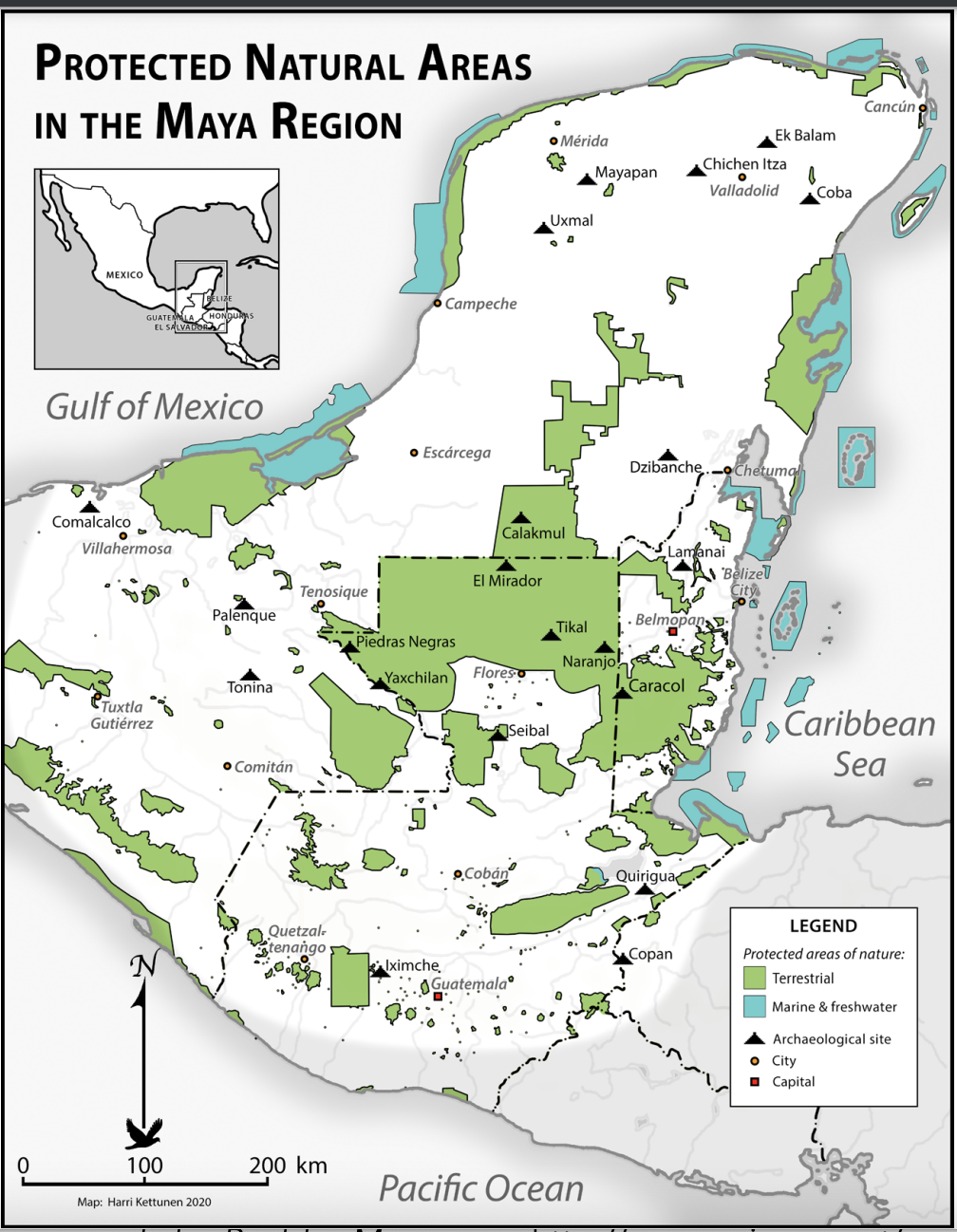
"Protected Natural Areas in the Maya Region" by Harri Kettunen 2020. In Kettunen, Harri, and Antonio Cuxil. “Indigenous People, National Parks, and Biodiversity in The Maya Region.” In Bridging Cultural Concepts of Nature: Indigenous People and Protected Spaces of Nature, edited by Rani-Henrik Andersson, Boyd Cothran, and Saara Kekki, 139–68. Helsinki University Press, 2021. http://www.jstor.org/stable/j.ctv26qjj3b.11.

  • Download Image

Reading in Spanish

Map 2000 - 2100

Protected Natural Areas in the Maya Region

  • Harri Kettunen

Published: 2020

  • Download Image
  • Download Image

Related Content

BRASIL

BRASIL

Map 1800 - 1899
Plano del Rio Tinto ó Piche

Plano del Rio Tinto ó Piche

Map 1700
REGIÓN OTOMI DE HIDALGO Y QUERETARO

REGIÓN OTOMI DE HIDALGO Y QUERETARO

Map 2000
Rio Para

Rio Para

Map 1700 - 1750
Carte d'une partie de la Riviere de Marony qui separe la Guïanne Françoise des Hollandois Levée depuis son embouchure, Jusqu'au premier Sault.

Carte d'une partie de la Riviere de Marony qui separe la Guïanne Françoise des Hollandois Levée depuis son embouchure, Jusqu'au premier Sault.

Map 1700 - 1799
FIGURAS DE ORDENAMIENTO TERRITORIAL EN LA SNSM

FIGURAS DE ORDENAMIENTO TERRITORIAL EN LA SNSM

Map 2009
Descripción geográfica de las conversiones de Nuestro Señor Padre San Francisco, pertenecientes al Colegio de Propaganda Fide de Santa Rosa de Ocopa y de los Ríos de Xauxa, Guanuco, Puzuzu y Ucayali, que tributan sus aguas al Marañón;corregida según las nuevas observaciones hechas por el P. Pr. Apostólico Fr. Joseph Amich, este año de 1767.

Descripción geográfica de las conversiones de Nuestro Señor Padre San Francisco, pertenecientes al Colegio de Propaganda Fide de Santa Rosa de Ocopa y de los Ríos de Xauxa, Guanuco, Puzuzu y Ucayali, que tributan sus aguas al Marañón;corregida según las nuevas observaciones hechas por el P. Pr. Apostólico Fr. Joseph Amich, este año de 1767.

Map 1767
MAP 8: SELECTED INDIGENOUS IDENTITY GROUPS IN ECUADOR;INCLUDING PUEBLOS

MAP 8: SELECTED INDIGENOUS IDENTITY GROUPS IN ECUADOR;INCLUDING PUEBLOS

Map 2009

Dispossessions in the Americas

A project by

University of Pennsylvania

Copyright 2024

With support from

Mellon Foundation

Site design & development

Element 84

Art Credits

“Protected Natural Areas in the Maya Region” by Harri Kettunen 2020. In Kettunen, Harri, and Antonio Cuxil. “Indigenous People, National Parks, and Biodiversity in The Maya Region.” In Bridging Cultural Concepts of Nature: Indigenous People and Protected Spaces of Nature, edited by Rani-Henrik Andersson, Boyd Cothran, and Saara Kekki, 139–68. Helsinki University Press, 2021. http://www.jstor.org/stable/j.ctv26qjj3b.11.

Site Pages

  • Home
  • Explore
  • About
  • Authors
  • Art
  • Bodies
  • Curricula
  • Cultural Heritage
  • Maps
  • Territories