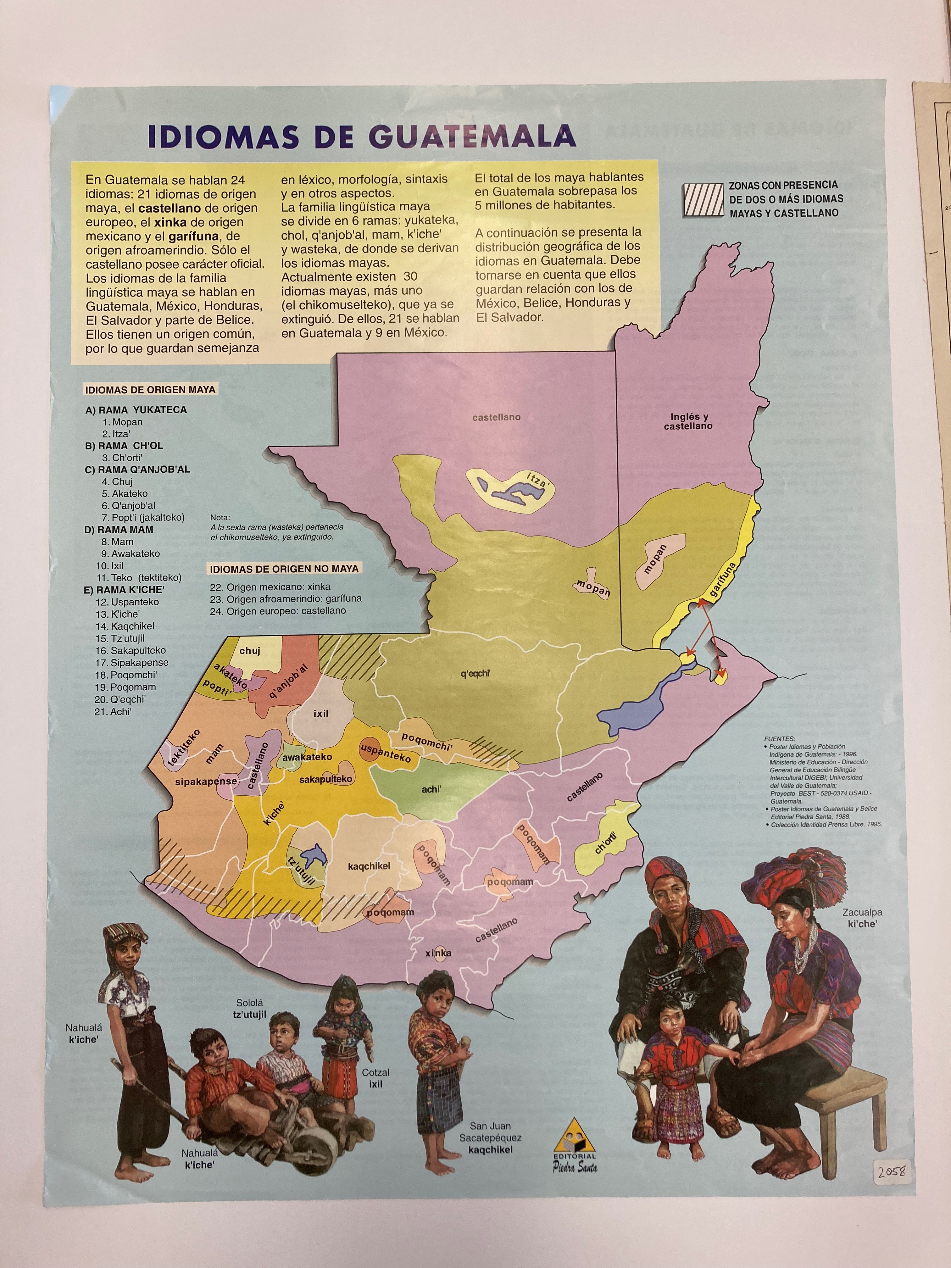
Dispossesions in the Americas

Dispossesions in the Americas

  • Home
  • Explore
  • About
  • Authors
  • Art
  • Bodies
  • Curricula
  • Cultural Heritage
  • Maps
  • Territories
Back to Explore
Map 1988

IDIOMAS DE GUATEMALA

    Published: 1988

    • Download Image

    Peoples

    • MOPAN
    • ITZA
    • CHORTI
    • CHUJ
    • AKATECO
    • QANJOBAL
    • POPTI
    • MAM
    • AWAKATECO
    • IXIL
    • TEKTITEKO
    • USPANTEC
    • KICHE
    • KAQCHIKEL
    • TZUTUJIL
    • SAKAPULTEC
    • SIPAKAPENSE
    • POQOMCHI
    • POQOMAM
    • QEQCHI
    • ACHI
    • XINKA
    • GARIFUNA

    Citation

    "IDIOMAS DE GUATEMALA." Map. 1988. 2058. Maps: Holdings. The Latin American Library at Tulane University, New Orleans, LA. https://library.tulane.edu/sites/default/files/media-files/LAL/LAL_Maps_Holdings.pdf

    • Download Image

    Reading in Spanish

    Map 1988

    IDIOMAS DE GUATEMALA

      Published: 1988

      • Download Image
      • Download Image

      Related Content

      FACSIMILE: NORTHERN PORTION OF SOUTH AMERICA

      FACSIMILE: NORTHERN PORTION OF SOUTH AMERICA

      Map 1703
      PUEBLO YAQUI

      PUEBLO YAQUI

      Map 2020
      Guaraní en Argentina 2016, Pueblos Guaraníes en América del Sur 2016

      Guaraní en Argentina 2016, Pueblos Guaraníes en América del Sur 2016

      Map 2016
      Sanapaná

      Sanapaná

      Map 2001
      Lamento Kayapó [Kayapó Lament]

      Lamento Kayapó [Kayapó Lament]

      Artwork
      Paraguariæ Provinciæ soc. jesu cum adiacentibg. novissima descriptio : post iteratas peregrinationes & plures observationes patrum missionariorum eiusdem soc. tum huius provinciæ;cum & Peruanæ accuratissime delineata & emendata ann. 1732

      Paraguariæ Provinciæ soc. jesu cum adiacentibg. novissima descriptio : post iteratas peregrinationes & plures observationes patrum missionariorum eiusdem soc. tum huius provinciæ;cum & Peruanæ accuratissime delineata & emendata ann. 1732

      Map 1732
      PUEBLO MATLATZINCA

      PUEBLO MATLATZINCA

      Map 2020
      A Map of part of Yucatan or of that Part of the Eastern Shore Within the Bay of Honduras Alloted to Great Britain for the Cutting of Logwood, in consequence of the Convention Signed with Spain on the 14th July 1786.

      A Map of part of Yucatan or of that Part of the Eastern Shore Within the Bay of Honduras Alloted to Great Britain for the Cutting of Logwood, in consequence of the Convention Signed with Spain on the 14th July 1786.

      Map 1700

      Dispossessions in the Americas

      A project by

      University of Pennsylvania

      Copyright 2024

      With support from

      Mellon Foundation

      Site design & development

      Element 84

      Art Credits

      “IDIOMAS DE GUATEMALA.” Map. 1988. 2058. Maps: Holdings. The Latin American Library at Tulane University, New Orleans, LA. https://library.tulane.edu/sites/default/files/media-files/LAL/LAL_Maps_Holdings.pdf

      Site Pages

      • Home
      • Explore
      • About
      • Authors
      • Art
      • Bodies
      • Curricula
      • Cultural Heritage
      • Maps
      • Territories