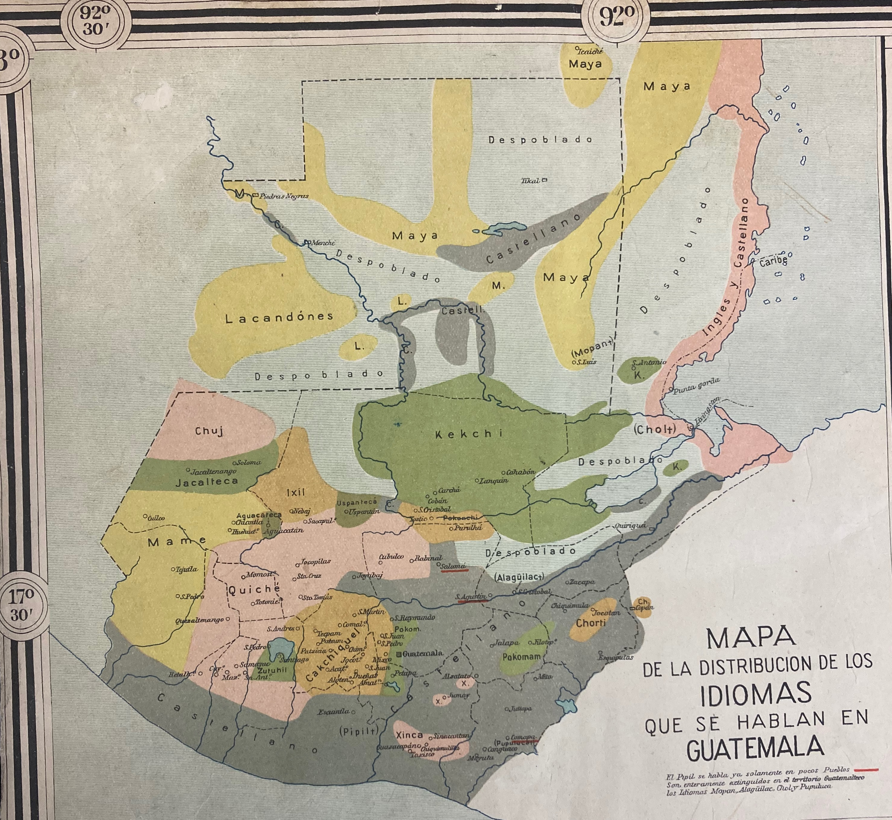
Dispossesions in the Americas

Dispossesions in the Americas

  • Home
  • Explore
  • About
  • Authors
  • Art
  • Bodies
  • Curricula
  • Cultural Heritage
  • Maps
  • Territories
Back to Explore
Map 1923

Mapa de la Distribucion de los Idiomas qu se hablan en Guatemala

  • CLAUDIO URRUTIA

Published: 1923

  • Download Image

Peoples

  • MAYA
  • LACANDON
  • CHUJ
  • KEKCHI
  • JACALTECA
  • IXIL
  • MAME
  • QUICHE
  • ZUTUHIL
  • CAKCHIQUEL
  • XINCA
  • POKOMAM
  • CHORTI
  • MOPAN
  • CHOL

Citation

Claudio Urrutia 1923 Mapa del Estado de Guatemala Republica de Centro America. edited by Claudio Urrutia, L. Friederichsen y Cia, Hamburg. Keywords: Guatemala. Call Number: 230 Notes: Three insets: 1) Altura de Volcanes Cerros, Cumbres y Lagunas, 2) Mapa de la Distribucion de los Idiomas que se hablan en Guatemala, 3) Mapa del Antiguo Reino de Guatemala en la Epoca de su Descubrimiento y Conquista. Abstract: Cities, towns, villages, ranches, post offices, ruins, mines, railways, telephone and telegraph offices, roads. https://library.tulane.edu/sites/default/files/media-files/LAL/LAL_Maps_Holdings.pdf

  • Download Image

Reading in Spanish

Map 1923

Mapa de la Distribucion de los Idiomas qu se hablan en Guatemala

  • CLAUDIO URRUTIA

Published: 1923

  • Download Image
  • Download Image

Related Content

PUEBLO MUNICHE

PUEBLO MUNICHE

Map 2021
PUEBLO AYAPANECO

PUEBLO AYAPANECO

Map 2020
SKETCH MAP OF BRITISH GUIANA

SKETCH MAP OF BRITISH GUIANA

Map 1835 - 1839
Map of Mapuche Land Dispossession for Chilean and German Settlers

Map of Mapuche Land Dispossession for Chilean and German Settlers

Map 1911 - 1952
PUEBLO AWAKATECO

PUEBLO AWAKATECO

Map 2020
The Caribee Islands and Guyana.

The Caribee Islands and Guyana.

Map 1700 - 1799
"Plano que demuestra la inmediación de Quibdó, último pueblo de Chocó, con los Indios Bárbaros nombrados Cunacunas, entre los que se hallan mezclados diferentes Naciones, como son ingleses, franceses, &."

"Plano que demuestra la inmediación de Quibdó, último pueblo de Chocó, con los Indios Bárbaros nombrados Cunacunas, entre los que se hallan mezclados diferentes Naciones, como son ingleses, franceses, &."

Map 1753
VISTA DE LA NUEVA POBLACION DE SAN FERNANDO DE GUADALUPE EN EL SALTO DE AGUA DEL RIO TULIJA, QUE LLEVA SU CORRIENTE A LAS LAGUNAS DE CHICHICASTE Y DE TÉRMINOS

VISTA DE LA NUEVA POBLACION DE SAN FERNANDO DE GUADALUPE EN EL SALTO DE AGUA DEL RIO TULIJA, QUE LLEVA SU CORRIENTE A LAS LAGUNAS DE CHICHICASTE Y DE TÉRMINOS

Map 1795

Dispossessions in the Americas

A project by

University of Pennsylvania

Copyright 2024

With support from

Mellon Foundation

Site design & development

Element 84

Art Credits

Claudio Urrutia 1923 Mapa del Estado de Guatemala Republica de Centro America. edited by Claudio Urrutia, L. Friederichsen y Cia, Hamburg. Keywords: Guatemala. Call Number: 230 Notes: Three insets: 1) Altura de Volcanes Cerros, Cumbres y Lagunas, 2) Mapa de la Distribucion de los Idiomas que se hablan en Guatemala, 3) Mapa del Antiguo Reino de Guatemala en la Epoca de su Descubrimiento y Conquista. Abstract: Cities, towns, villages, ranches, post offices, ruins, mines, railways, telephone and telegraph offices, roads. https://library.tulane.edu/sites/default/files/media-files/LAL/LAL_Maps_Holdings.pdf

Site Pages

  • Home
  • Explore
  • About
  • Authors
  • Art
  • Bodies
  • Curricula
  • Cultural Heritage
  • Maps
  • Territories