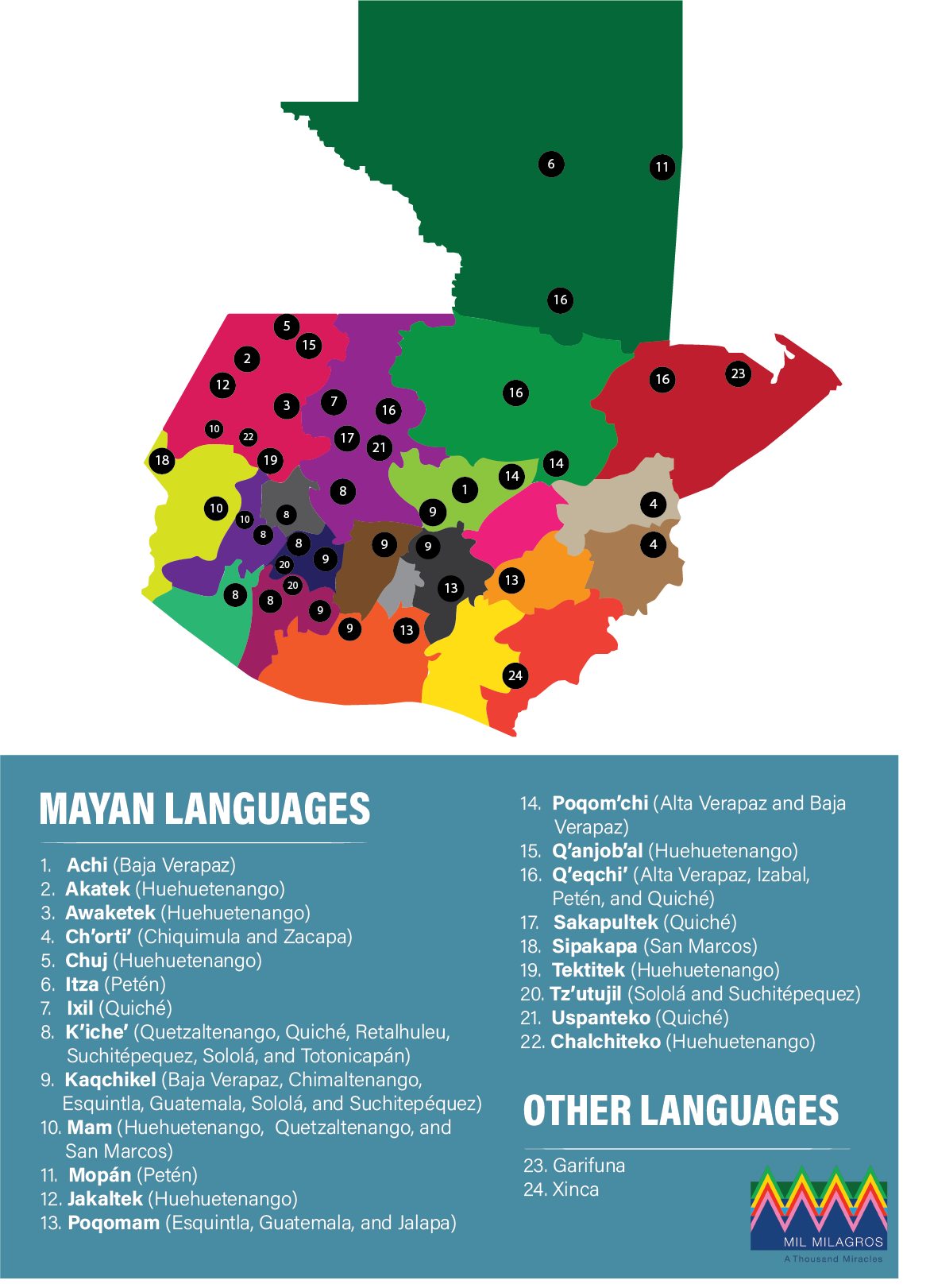
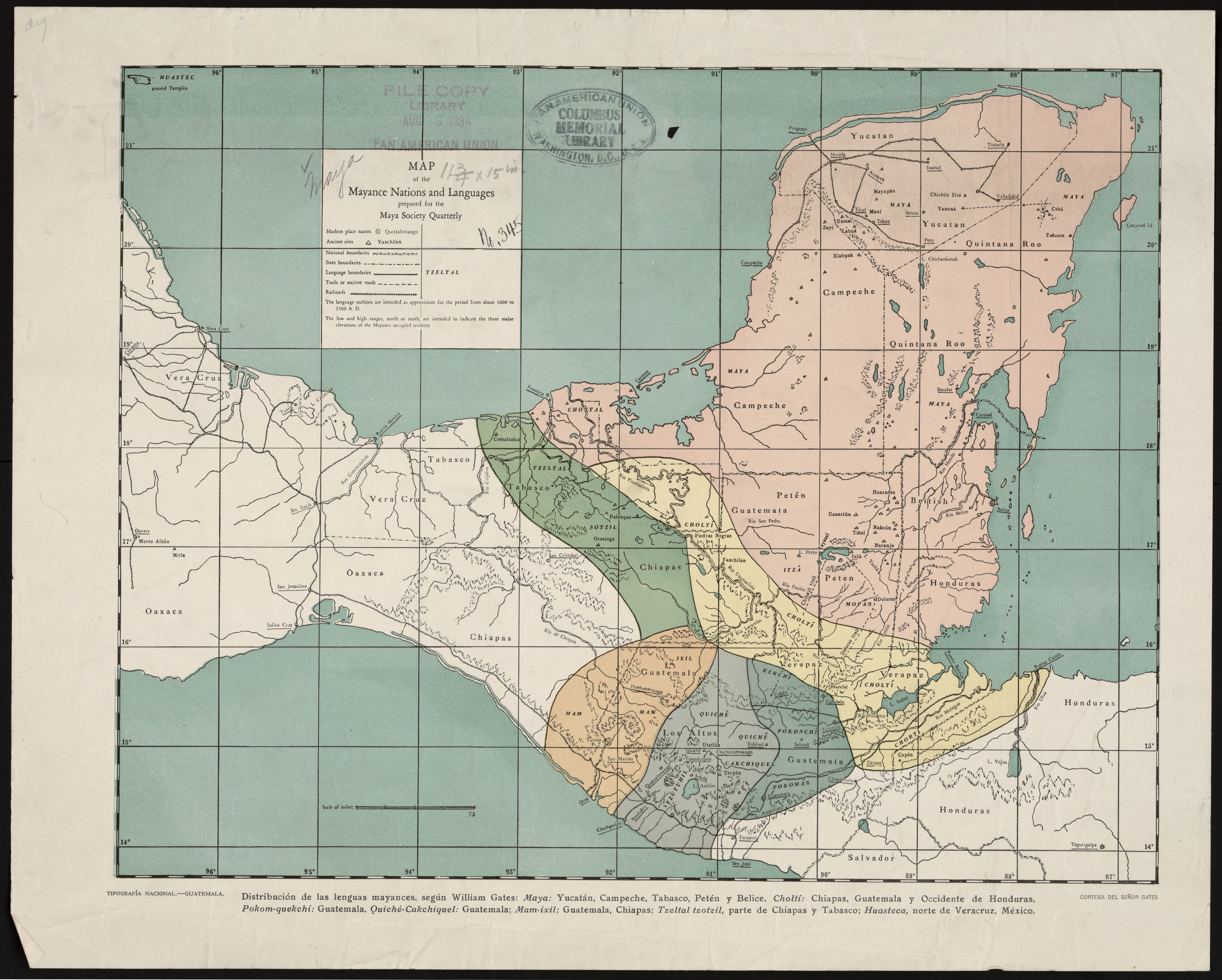
Dispossesions in the Americas

Dispossesions in the Americas

  • Home
  • Explore
  • About
  • Authors
  • Art
  • Bodies
  • Curricula
  • Cultural Heritage
  • Maps
  • Territories
Back to Explore
Map 1000 - 1500

Map of the Mayance Nations and Languages

  • WILLIAM E. GATES

Published: 1934

  • Download Image

Peoples

  • CHORTI
  • CHOLTI
  • POKOMAN
  • POKONCHI
  • CAKCHIQUEL
  • TZUTUHIL
  • QUICHE
  • MAM
  • IXIL
  • KEKCHI
  • MOPAN
  • ITZA
  • MAYA
  • SOTZIL
  • TZELTAL
  • CHONTAL

Citation

Gates, William E. Map of the Mayance Nations and Languages. Map. Guatemala: National Printing Office, 1934. Accessed December 20, 2021. https://www.loc.gov/resource/gdcwdl.wdl_11311/?r=-0.219,-0.006,1.336,0.619,0.

  • Download Image

Reading in Spanish

Map 1000 - 1500

Map of the Mayance Nations and Languages

  • WILLIAM E. GATES

Published: 1934

  • Download Image
  • Download Image

Reading in Portuguese

Map 1000 - 1500

Map of the Mayance Nations and Languages

  • WILLIAM E. GATES

Published: 1934

  • Download Image

Peoples

  • CHORTI
  • CHOLTI
  • POKOMAN
  • POKONCHI
  • CAKCHIQUEL
  • TZUTUHIL
  • QUICHE
  • MAM
  • IXIL
  • KEKCHI
  • MOPAN
  • ITZA
  • MAYA
  • SOTZIL
  • TZELTAL
  • CHONTAL

Citation

Gates, William E. Map of the Mayance Nations and Languages. Map. Guatemala: National Printing Office, 1934. Accessed December 20, 2021. https://www.loc.gov/resource/gdcwdl.wdl_11311/?r=-0.219,-0.006,1.336,0.619,0.

  • Download Image

Related Content

Indigenous languages in Guatemala

Indigenous languages in Guatemala

Map
PLANTA DA MARCHA DO 2º CORPO DO EXERCITO BRAZILEIRO DO RIO URUGUAY AO PARANÀ em 1866

PLANTA DA MARCHA DO 2º CORPO DO EXERCITO BRAZILEIRO DO RIO URUGUAY AO PARANÀ em 1866

Map 1866
MAPA CORO-GRÁFICO DE LA NUEVA ANDALUCIA

MAPA CORO-GRÁFICO DE LA NUEVA ANDALUCIA

Map 1778
Mixe-Zoque-Popoluca Distribution

Mixe-Zoque-Popoluca Distribution

Map 1969
Maya Land Use in the Toledo and Stann Creek Districts, Southern Belize

Maya Land Use in the Toledo and Stann Creek Districts, Southern Belize

Map 1997
Carte de la Moskitie oú se fonde la Neustrie

Carte de la Moskitie oú se fonde la Neustrie

Map 1830
Model to Assemble and Disassemble a Water Fountain

Model to Assemble and Disassemble a Water Fountain

Artwork
PROVINCIE DELLO SPIRITO SANTO E DI PORTO SICURO

PROVINCIE DELLO SPIRITO SANTO E DI PORTO SICURO

Map 1600 - 1699

Dispossessions in the Americas

A project by

University of Pennsylvania

Copyright 2024

With support from

Mellon Foundation

Site design & development

Element 84

Art Credits

Gates, William E. Map of the Mayance Nations and Languages. Map. Guatemala: National Printing Office, 1934. Accessed December 20, 2021. https://www.loc.gov/resource/gdcwdl.wdl_11311/?r=-0.219,-0.006,1.336,0.619,0.

Site Pages

  • Home
  • Explore
  • About
  • Authors
  • Art
  • Bodies
  • Curricula
  • Cultural Heritage
  • Maps
  • Territories