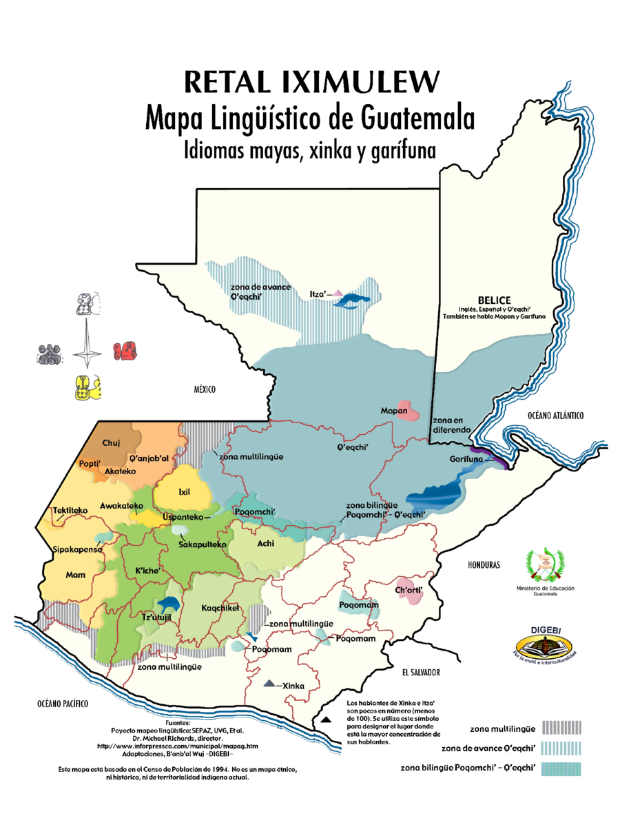
Dispossesions in the Americas

Dispossesions in the Americas

  • Home
  • Explore
  • About
  • Authors
  • Art
  • Bodies
  • Curricula
  • Cultural Heritage
  • Maps
  • Territories
Back to Explore
Map 1994

RETAL IXIMULEW Mapa Lingüístico de Guatemala Idiomas mayas, xinka y garífuna

  • SEPAZ, UVG, ET AL.

  • Download Image

Peoples

  • ITZA
  • QEQCHI
  • MOPAN
  • GARIFUNA
  • CHORTI
  • POQOMAM
  • XINKA
  • POQOMCHI
  • ACHI
  • KAQCHIKEL
  • TZUTUJIL
  • KICHE
  • SAKAPULTEKO
  • USPANTEKO
  • IXIL
  • QANJOBAL
  • CHUJ
  • AKATEKO
  • POPTI
  • AWAKATEKO
  • TEKTITEKO
  • SIPAKAPENSE
  • MAM

Citation

SEPAZ, UVG, ET AL. "Guatemala, un País con Diversidad Étnica, Cultural y Lingüística" [Guatemala, a Country with Ethnic, Cultural and Linguistic Diversity]. Ministerio de Educacion. Accessed September 30, 2021. https://www.mineduc.gob.gt/DIGEBI/mapaLinguistico.html.

  • Download Image

Reading in Spanish

Map 1994

RETAL IXIMULEW Mapa Lingüístico de Guatemala Idiomas mayas, xinka y garífuna

  • SEPAZ, UVG, ET AL.

  • Download Image
  • Download Image

Related Content

Current Ethno-Linguistic Groups of South America

Current Ethno-Linguistic Groups of South America

Map 1990
Reducción del territorio Barí 1950 -1970

Reducción del territorio Barí 1950 -1970

Map 1950 - 1970
Outlines of the physical and political division of South America: Delineated by A. Arrowsmith partly from scarce and original documents, published before the year 1806 but principally from manuscript maps & surveys made between the years 1771 and 1806, corrected from accurate astronomical observations to 1810.

Outlines of the physical and political division of South America: Delineated by A. Arrowsmith partly from scarce and original documents, published before the year 1806 but principally from manuscript maps & surveys made between the years 1771 and 1806, corrected from accurate astronomical observations to 1810.

Map 1800 - 1899
Area of Tarascan Speech about 1850

Area of Tarascan Speech about 1850

Map 1850
PUEBLO MASTANAHUA

PUEBLO MASTANAHUA

Map 2021
THE AYMARA POLITY OF THE LUPAQA: COMMERCIAL DESTINIES AND VERTICALITY IN THE 16TH CENTURY

THE AYMARA POLITY OF THE LUPAQA: COMMERCIAL DESTINIES AND VERTICALITY IN THE 16TH CENTURY

Map 1500 - 1599
NAYARIT

NAYARIT

Map 2015
INTENDENCIA DE ZACATECAS

INTENDENCIA DE ZACATECAS

Map 1800

Dispossessions in the Americas

A project by

University of Pennsylvania

Copyright 2024

With support from

Mellon Foundation

Site design & development

Element 84

Art Credits

SEPAZ, UVG, ET AL. “Guatemala, un País con Diversidad Étnica, Cultural y Lingüística” [Guatemala, a Country with Ethnic, Cultural and Linguistic Diversity]. Ministerio de Educacion. Accessed September 30, 2021. https://www.mineduc.gob.gt/DIGEBI/mapaLinguistico.html.

Site Pages

  • Home
  • Explore
  • About
  • Authors
  • Art
  • Bodies
  • Curricula
  • Cultural Heritage
  • Maps
  • Territories