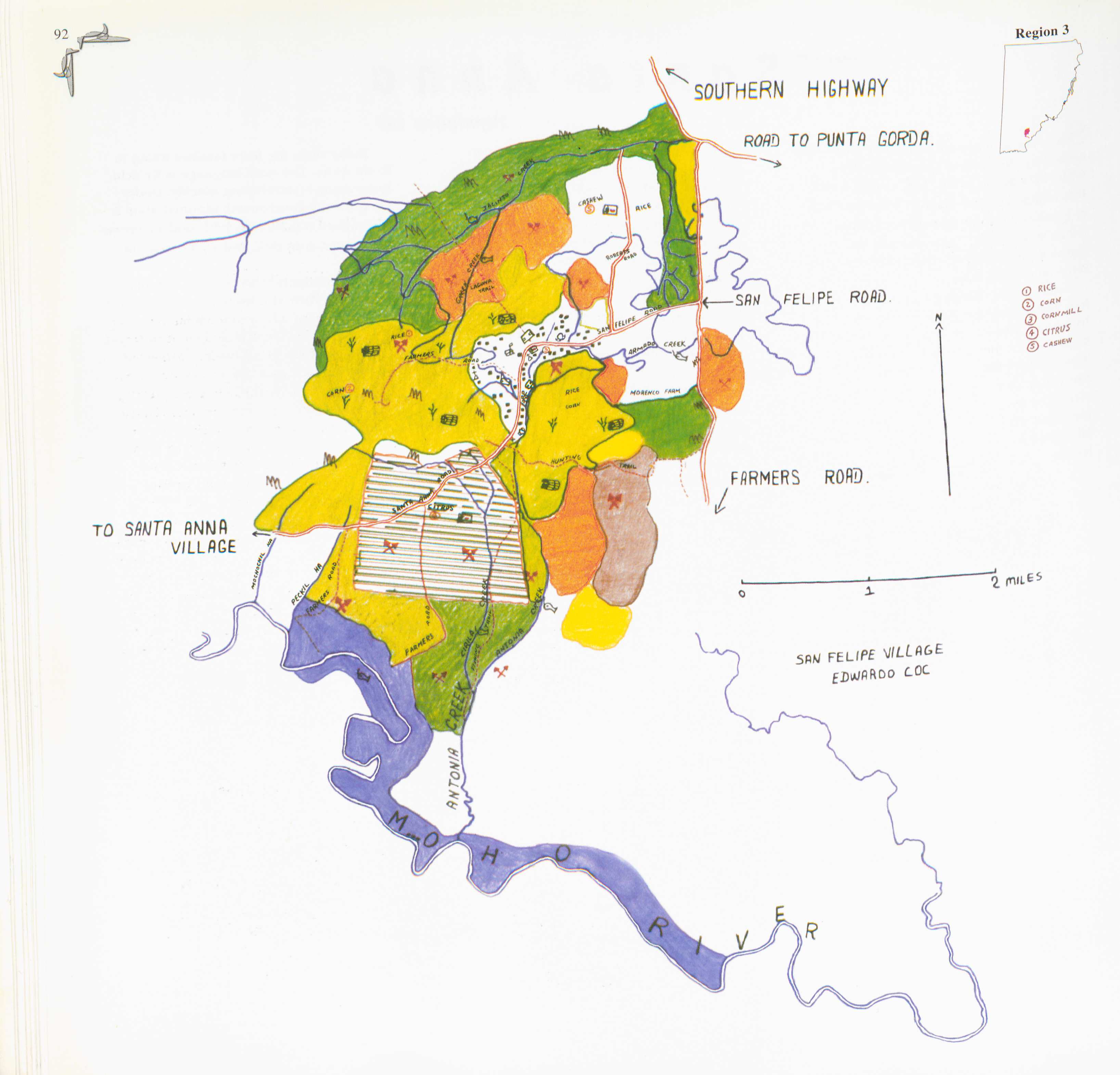
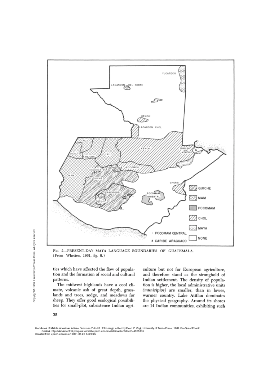
Dispossesions in the Americas

Dispossesions in the Americas

  • Home
  • Explore
  • About
  • Authors
  • Art
  • Bodies
  • Curricula
  • Cultural Heritage
  • Maps
  • Territories
Back to Explore
Map 1961

PRESENT-DAY MAYA LANGUAGE BOUNDARIES OF GUATEMALA

  • WHETTEN

Published: 1961

  • Download Image

Peoples

  • LANCANDON
  • YUCATECO
  • KEKCHI
  • CHOL
  • CHUJ
  • JACALTECA
  • KANJOBAL
  • IXIL
  • MAM
  • AGUACATECA
  • USPANTECA
  • POCOMCHI
  • QUICHE
  • TZUTUJIL
  • CAKCHIQUEL
  • POCOMAM
  • CHORTI

Citation

Nash, Manning. "3. Guatemalan Highlands." In Ethnology, Part 1, edited by Robert Wauchope and Evon Z. Vogt, 30. Vol. 7 of Handbook of Middle American Indians. Austin: University of Texas Press, 1969. https://hdl.handle.net/2027/uva.x000908468.

  • Download Image

Reading in Spanish

Map 1961

PRESENT-DAY MAYA LANGUAGE BOUNDARIES OF GUATEMALA

  • WHETTEN

Published: 1961

  • Download Image
  • Download Image

Reading in Portuguese

Map 1961

PRESENT-DAY MAYA LANGUAGE BOUNDARIES OF GUATEMALA

  • WHETTEN

Published: 1961

  • Download Image

Peoples

  • LANCANDON
  • YUCATECO
  • KEKCHI
  • CHOL
  • CHUJ
  • JACALTECA
  • KANJOBAL
  • IXIL
  • MAM
  • AGUACATECA
  • USPANTECA
  • POCOMCHI
  • QUICHE
  • TZUTUJIL
  • CAKCHIQUEL
  • POCOMAM
  • CHORTI

Citation

Nash, Manning. "3. Guatemalan Highlands." In Ethnology, Part 1, edited by Robert Wauchope and Evon Z. Vogt, 30. Vol. 7 of Handbook of Middle American Indians. Austin: University of Texas Press, 1969. https://hdl.handle.net/2027/uva.x000908468.

  • Download Image

Related Content

San Felipe

San Felipe

Map 1997
PUEBLO MATSIGENKA

PUEBLO MATSIGENKA

Map 2021
DISTRIBUCION DE GRUPOS CON LENGUAS CHIBCHAS

DISTRIBUCION DE GRUPOS CON LENGUAS CHIBCHAS

Map 2019
The Bosawa Reserve and Indigenous Territories;Nicaragua.

The Bosawa Reserve and Indigenous Territories;Nicaragua.

Map 2000 - 2003
The Tarahumar Country, 1959

The Tarahumar Country, 1959

Map 1959
Mapa de la Peninsula Goagira

Mapa de la Peninsula Goagira

Map 1762
Carte de la Neustrie dressé ainsi que la carte générale;d'aprés les cartes de Jn. Purdy;celles de Th Jefferys;corrigées;etc.;etc/

Carte de la Neustrie dressé ainsi que la carte générale;d'aprés les cartes de Jn. Purdy;celles de Th Jefferys;corrigées;etc.;etc/

Map 1830
KUMEYAAY LANDS 1769-2000

KUMEYAAY LANDS 1769-2000

Map 2000

Dispossessions in the Americas

A project by

University of Pennsylvania

Copyright 2024

With support from

Mellon Foundation

Site design & development

Element 84

Art Credits

Nash, Manning. “3. Guatemalan Highlands.” In Ethnology, Part 1, edited by Robert Wauchope and Evon Z. Vogt, 30. Vol. 7 of Handbook of Middle American Indians. Austin: University of Texas Press, 1969. https://hdl.handle.net/2027/uva.x000908468.

Site Pages

  • Home
  • Explore
  • About
  • Authors
  • Art
  • Bodies
  • Curricula
  • Cultural Heritage
  • Maps
  • Territories