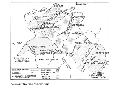
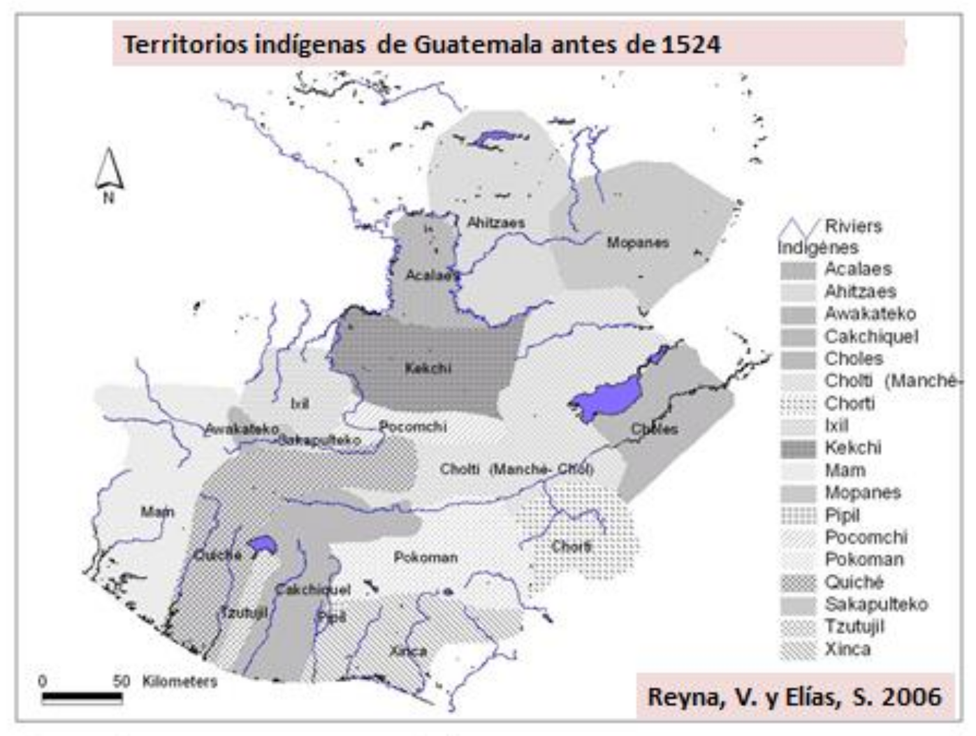
Dispossesions in the Americas

Dispossesions in the Americas

  • Home
  • Explore
  • About
  • Authors
  • Art
  • Bodies
  • Curricula
  • Cultural Heritage
  • Maps
  • Territories
Back to Explore
Map 1523

Territorios indígenas de Guatemala antes de 1524

  • REYNA, V., ET AL.

Published: 2006

  • Download Image

Peoples

  • ACALAES
  • AHITZAES
  • AWAKATEKO
  • CAKCHIQUEL
  • CHOLES
  • CHOLTIMANCHE
  • CHORTI
  • IXIL
  • KEKCHI
  • MAM
  • MOPANES
  • PIPIL
  • POCOMCHI
  • POKOMAN
  • QUICHE
  • SAKAPULTEKO
  • TZUTUJIL
  • XINCA

Citation

Elías, Silvel. "Territorios y áreas conservadas por pueblos indígenas y comunidades locales (TICCA): raíces y evolución histórica, amenazas y oportunidades actuales y posible estrategia de reconocimiento y fortalecimiento en Mesoamérica." Working paper, 2001. https://www.iccaconsortium.org/wp-content/uploads/2016/03/TICCA_Mesoamerica_Selias-first-draft-es.pdf.

  • Download Image

Reading in Spanish

Map 1523

Territorios indígenas de Guatemala antes de 1524

  • REYNA, V., ET AL.

Published: 2006

  • Download Image
  • Download Image

Reading in Portuguese

Map 1523

Territorios indígenas de Guatemala antes de 1524

  • REYNA, V., ET AL.

Published: 2006

  • Download Image

Peoples

  • ACALAES
  • AHITZAES
  • AWAKATEKO
  • CAKCHIQUEL
  • CHOLES
  • CHOLTIMANCHE
  • CHORTI
  • IXIL
  • KEKCHI
  • MAM
  • MOPANES
  • PIPIL
  • POCOMCHI
  • POKOMAN
  • QUICHE
  • SAKAPULTEKO
  • TZUTUJIL
  • XINCA

Citation

Elías, Silvel. "Territorios y áreas conservadas por pueblos indígenas y comunidades locales (TICCA): raíces y evolución histórica, amenazas y oportunidades actuales y posible estrategia de reconocimiento y fortalecimiento en Mesoamérica." Working paper, 2001. https://www.iccaconsortium.org/wp-content/uploads/2016/03/TICCA_Mesoamerica_Selias-first-draft-es.pdf.

  • Download Image

Related Content

Mapa intelectual o idea formada de lo que es el Río del Darién o Atrato sacada por Relación de los nat[urales] de aquel Pais: Contiene las bocas principales de d[ic]hos Rios, sus cienegas, caños y riecitos que dan agua a d[ic]ho Pr[incip]al. Año de 1781. A.A.

Mapa intelectual o idea formada de lo que es el Río del Darién o Atrato sacada por Relación de los nat[urales] de aquel Pais: Contiene las bocas principales de d[ic]hos Rios, sus cienegas, caños y riecitos que dan agua a d[ic]ho Pr[incip]al. Año de 1781. A.A.

Map 1781
Chinantla Subregions

Chinantla Subregions

Map 1969
Población comcaac (seri) en 2010

Población comcaac (seri) en 2010

Map 2010
Outside Threats to Maya Lands

Outside Threats to Maya Lands

Map 1997
Fig. 1. Map of French Guiana with locations of the various Amerindian groups

Fig. 1. Map of French Guiana with locations of the various Amerindian groups

Map 1999
Collection of different versions of the Peru Jaguar, Peru Otorongo, and the “Perucitos”

Collection of different versions of the Peru Jaguar, Peru Otorongo, and the “Perucitos”

Artwork
Outlines of the physical and political division of South America: Delineated by A. Arrowsmith partly from scarce and original documents, published before the year 1806 but principally from manuscript maps & surveys made between the years 1771 and 1806, corrected from accurate astronomical observations to 1810.

Outlines of the physical and political division of South America: Delineated by A. Arrowsmith partly from scarce and original documents, published before the year 1806 but principally from manuscript maps & surveys made between the years 1771 and 1806, corrected from accurate astronomical observations to 1810.

Map 1800 - 1899
Mapa de la Republica de Guatemala, America Central

Mapa de la Republica de Guatemala, America Central

Map 1880 - 1900

Dispossessions in the Americas

A project by

University of Pennsylvania

Copyright 2024

With support from

Mellon Foundation

Site design & development

Element 84

Art Credits

Elías, Silvel. “Territorios y áreas conservadas por pueblos indígenas y comunidades locales (TICCA): raíces y evolución histórica, amenazas y oportunidades actuales y posible estrategia de reconocimiento y fortalecimiento en Mesoamérica.” Working paper, 2001. https://www.iccaconsortium.org/wp-content/uploads/2016/03/TICCA_Mesoamerica_Selias-first-draft-es.pdf.

Site Pages

  • Home
  • Explore
  • About
  • Authors
  • Art
  • Bodies
  • Curricula
  • Cultural Heritage
  • Maps
  • Territories