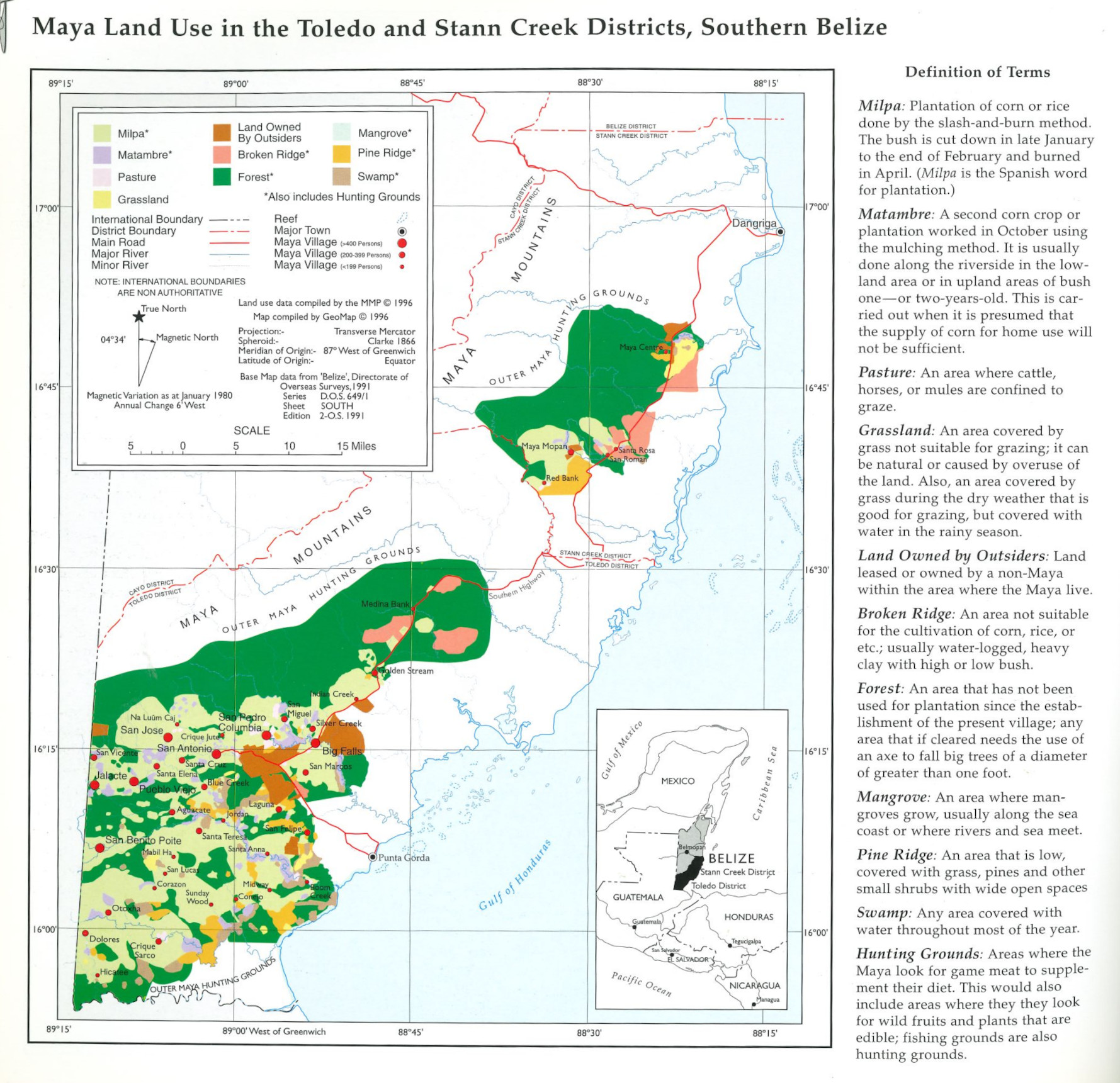
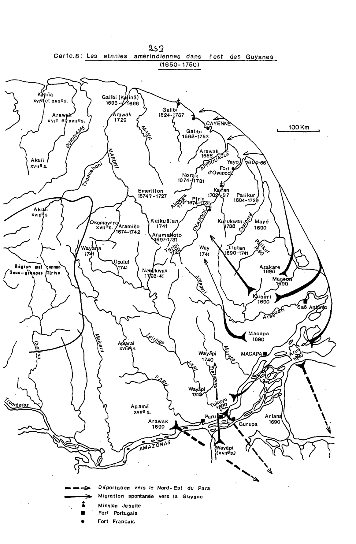
Dispossesions in the Americas

Dispossesions in the Americas

  • Home
  • Explore
  • About
  • Authors
  • Art
  • Bodies
  • Curricula
  • Cultural Heritage
  • Maps
  • Territories
Back to Explore
Map 1650 - 1750

Carte 8: Les ethnies amérindiennes dans l'est des Guyanes (1650-1750)

  • GRENAND, PIERRE

Published: 1982

  • Download Image

Peoples

  • AKOKWA
  • AKULI
  • APAMA
  • APARAI
  • ARAKARE
  • ARAMISO
  • ARAMAKOTO
  • ARAWAK
  • ARIANA
  • ARUA
  • EMERILLON
  • GALIBI
  • ITUTAN
  • KAIKUSIAN
  • KALINA
  • KARAN
  • KUSARI
  • MACAPA
  • MARAON
  • MAYE
  • NAMIKWAN
  • NORAK
  • OKOMAYANA
  • PALIKUR
  • PIRIU
  • TARIPI
  • UPULUI
  • WAY
  • WAYANA
  • WAYAPI

Citation

Grenand, Pierre. Ainsi parlaient nos ancêtres : essai d'ethnohistoire « waŷapi ». Paris: ORSTOM, 1982.

  • Download Image

Reading in Spanish

Map 1650 - 1750

Carte 8: Les ethnies amérindiennes dans l'est des Guyanes (1650-1750)

  • GRENAND, PIERRE

Published: 1982

  • Download Image
  • Download Image

Related Content

Fig. 1.1 Locations of peoples discussed in this volume

Fig. 1.1 Locations of peoples discussed in this volume

Map 1900 - 1999
Detail from the 1770 copy of Francisco Álvarez Barreiro’s 1728 map of northern New Spain illustrating Spanish mapping of Indian domains in southern Texas and along the Gulf Coast, especially through the repetition of labels: “tierra de los Pampopas,” “tierra de los Carrizos,” “tierra de los Cujanes,” etc.

Detail from the 1770 copy of Francisco Álvarez Barreiro’s 1728 map of northern New Spain illustrating Spanish mapping of Indian domains in southern Texas and along the Gulf Coast, especially through the repetition of labels: “tierra de los Pampopas,” “tierra de los Carrizos,” “tierra de los Cujanes,” etc.

Map 1728
Tribes of the Gran Chaco: Locations at the first European contact

Tribes of the Gran Chaco: Locations at the first European contact

Map 1524
Obispado de Tlaxcala

Obispado de Tlaxcala

Map 1500 - 1599
CARTE DU GRAND CHACO (TERRITOIRE INDIEN DU NORD) et DES CONTRÉES VOISINES

CARTE DU GRAND CHACO (TERRITOIRE INDIEN DU NORD) et DES CONTRÉES VOISINES

Map 1520
Qom-lik

Qom-lik

Map 2001
PUEBLO JAQARU

PUEBLO JAQARU

Map 2021
Carte de la cote orientale Du Brésil entre le 15e et le 23e degré de latitude australe

Carte de la cote orientale Du Brésil entre le 15e et le 23e degré de latitude australe

Map 1821

Dispossessions in the Americas

A project by

University of Pennsylvania

Copyright 2024

With support from

Mellon Foundation

Site design & development

Element 84

Art Credits

Grenand, Pierre. Ainsi parlaient nos ancêtres : essai d’ethnohistoire « waŷapi ». Paris: ORSTOM, 1982.

Site Pages

  • Home
  • Explore
  • About
  • Authors
  • Art
  • Bodies
  • Curricula
  • Cultural Heritage
  • Maps
  • Territories