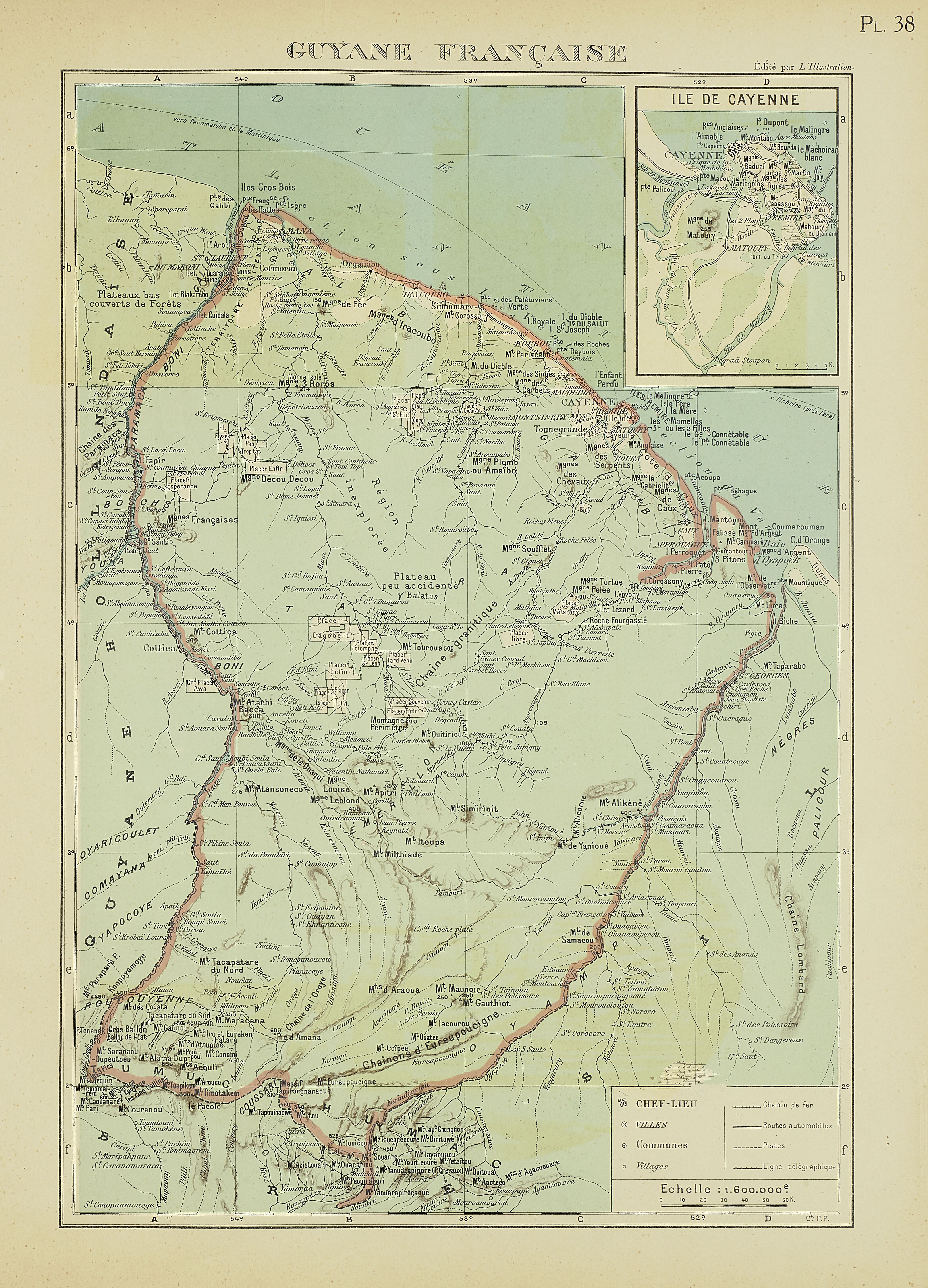
Dispossesions in the Americas

Dispossesions in the Americas

  • Home
  • Explore
  • About
  • Authors
  • Art
  • Bodies
  • Curricula
  • Cultural Heritage
  • Maps
  • Territories
Back to Explore
Map 1929

PL 38: Guyane française.

  • POLLACCHI, PAUL

Published: 1929

  • Download Image

Peoples

  • BOSCHS
  • COMAYANA
  • COUSSARI
  • EMERILLON
  • GALIBI
  • OYAMPIS
  • OYARICOULET
  • PALICOUR
  • ROUCOUYENNE
  • TAYRA
  • YAPOCOYE

Citation

Atlas colonial français : colonies, protectorats et pays sous mandat. Cartes et texte du Commandant P. Pollacchi. Gallica. Last modified: October 28, 2020. Accessed, August 1, 2023. https://gallica.bnf.fr/ark:/12148/bpt6k1100182m/f253.item

  • Download Image

Reading in Spanish

Map 1929

PL 38: Guyane française.

  • POLLACCHI, PAUL

Published: 1929

  • Download Image
  • Download Image

Related Content

Map of deforestation within protected areas in Guatemala and adjoining areas

Map of deforestation within protected areas in Guatemala and adjoining areas

Map 2000 - 2100
Paraguay, ó prov. de Rio de la Plata cum regionibus adiacentibus Tucuman et Sta. Cruz de la Sierra

Paraguay, ó prov. de Rio de la Plata cum regionibus adiacentibus Tucuman et Sta. Cruz de la Sierra

Map 1633
Map of Sonora, Showing Historic Location of Pima Bajo, Opata, Papago, and Seri Indians in 1960

Map of Sonora, Showing Historic Location of Pima Bajo, Opata, Papago, and Seri Indians in 1960

Map 1960
"Descripción del Valle de Chimo y planisphérica de la Ciudad de Truxillo del Perú".

"Descripción del Valle de Chimo y planisphérica de la Ciudad de Truxillo del Perú".

Map 1760
EL SEÑORÍO AYMARA DE LOS SURAS EN EL SIGLO XVI

EL SEÑORÍO AYMARA DE LOS SURAS EN EL SIGLO XVI

Map 1500 - 1699
Honduras: Distribution of ethnic groups, ca. 1980 (Davidson and Counce 1989)

Honduras: Distribution of ethnic groups, ca. 1980 (Davidson and Counce 1989)

Map 1980
Map of the RIVER JURUÁ

Map of the RIVER JURUÁ

Map 1869
[Carta particolare della costa di Guiana]

[Carta particolare della costa di Guiana]

Map 1600 - 1699

Dispossessions in the Americas

A project by

University of Pennsylvania

Copyright 2024

With support from

Mellon Foundation

Site design & development

Element 84

Art Credits

Atlas colonial français : colonies, protectorats et pays sous mandat. Cartes et texte du Commandant P. Pollacchi. Gallica. Last modified: October 28, 2020. Accessed, August 1, 2023. https://gallica.bnf.fr/ark:/12148/bpt6k1100182m/f253.item

Site Pages

  • Home
  • Explore
  • About
  • Authors
  • Art
  • Bodies
  • Curricula
  • Cultural Heritage
  • Maps
  • Territories