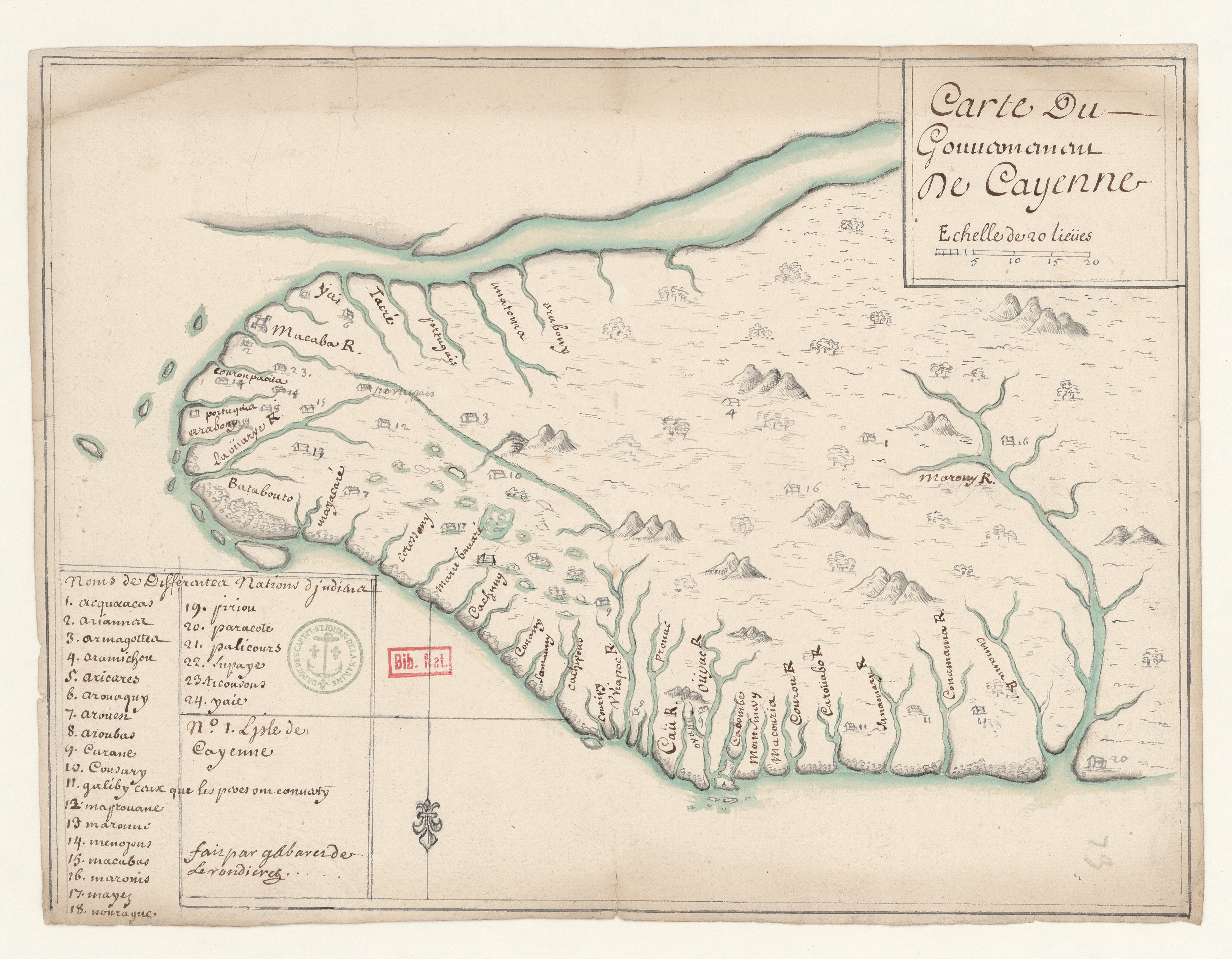
Dispossesions in the Americas

Dispossesions in the Americas

  • Home
  • Explore
  • About
  • Authors
  • Art
  • Bodies
  • Curricula
  • Cultural Heritage
  • Maps
  • Territories
Back to Explore
Map 1700 - 1799

Carte du Gouvernement de Cayenne.

  • GABARET DE LA RONDIÈRE

Published: 1700

  • Download Image

Peoples

  • ACQUACAS
  • ARIANNOU
  • ARMAGOTTEA
  • ARAMICHOU
  • ARICARES
  • AROUAQUY
  • AROUEN
  • AROUBAS
  • CURANE
  • COUSARY
  • GALIBY
  • MAPROUANE
  • MARONNI
  • MENOYONS
  • MACUBUS
  • MARONIS
  • MAYEZ
  • NOURAGUE
  • PIRIOU
  • PARACOTE
  • PALICOURS
  • SUPAYE
  • TICOUSOUS
  • YAIE

Citation

Carte du Gouvernement de Cayenne / fait par Gabaret de Larondieres. Gallica. Last modified: September 21, 2015. Accessed, July 15, 2023. https://gallica.bnf.fr/ark:/12148/btv1b53103527c

  • Download Image

Reading in Spanish

Map 1700 - 1799

Carte du Gouvernement de Cayenne.

  • GABARET DE LA RONDIÈRE

Published: 1700

  • Download Image
  • Download Image

Related Content

CÓDICE FEJÉRVARY-MAYER, FOLIO 1

CÓDICE FEJÉRVARY-MAYER, FOLIO 1

Map 1400 - 1599
Plata, Chili, Paraguay Et Patagonie

Plata, Chili, Paraguay Et Patagonie

Map 1800 - 1880
Geographic Distribution of the Zapotec, Oaxaca

Geographic Distribution of the Zapotec, Oaxaca

Map 1969
CARTE DES REPUBLIQUES DE L'EQUATEUR;DE COLOMBIE;DE VENEZUELA;ET GUYANES FRANCAISE;HOLLANDAISE;ET ANGLAISE

CARTE DES REPUBLIQUES DE L'EQUATEUR;DE COLOMBIE;DE VENEZUELA;ET GUYANES FRANCAISE;HOLLANDAISE;ET ANGLAISE

Map 1875
PUEBLO SHIWILU

PUEBLO SHIWILU

Map 2021
Indianische Ortsnamed im nördlichen Mittelamerika

Indianische Ortsnamed im nördlichen Mittelamerika

Map 1800 - 1900
Map of the basin of La Plata : based upon the results of the expedition under the command of Thos. J. Page;U.S. Navy;in the years 1853;-'54;-'55;& 56 and of the adjacent countries

Map of the basin of La Plata : based upon the results of the expedition under the command of Thos. J. Page;U.S. Navy;in the years 1853;-'54;-'55;& 56 and of the adjacent countries

Map 1853 - 1856
STRENGTHENING INDIGENOUS LAND RIGHTS IN COLOMBIA

STRENGTHENING INDIGENOUS LAND RIGHTS IN COLOMBIA

Map 2019 - 2020

Dispossessions in the Americas

A project by

University of Pennsylvania

Copyright 2024

With support from

Mellon Foundation

Site design & development

Element 84

Art Credits

Carte du Gouvernement de Cayenne / fait par Gabaret de Larondieres. Gallica. Last modified: September 21, 2015. Accessed, July 15, 2023. https://gallica.bnf.fr/ark:/12148/btv1b53103527c

Site Pages

  • Home
  • Explore
  • About
  • Authors
  • Art
  • Bodies
  • Curricula
  • Cultural Heritage
  • Maps
  • Territories