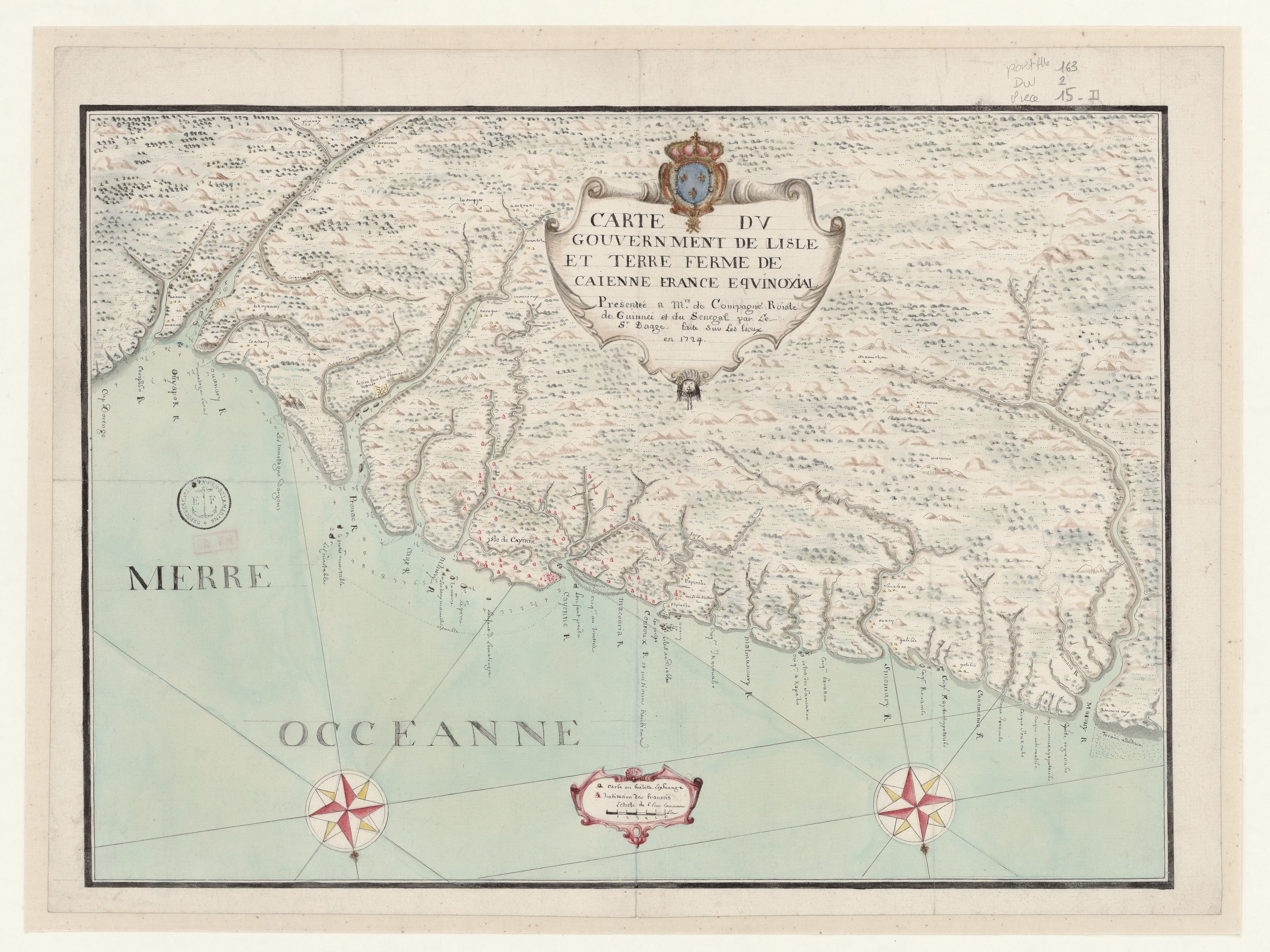
Dispossesions in the Americas

Dispossesions in the Americas

  • Home
  • Explore
  • About
  • Authors
  • Art
  • Bodies
  • Curricula
  • Cultural Heritage
  • Maps
  • Territories
Back to Explore
Map 1724

Carte du gouvernement de lisle et terre ferme de Caienne France equinoxial.

  • COLMET-DAAGE, F.

Published: 1724

  • Download Image

Peoples

  • ACOKOUAS
  • ACOQUOES
  • AMANTOKOU
  • ARAMICHOU
  • ARICURES
  • CARANNES
  • COUSARY
  • GALIBIS
  • MORONIS
  • MOURIOUX
  • NORAGUE
  • OUARY
  • OUYYESPIRIOUX
  • PIRIOUX
  • SARABIAS
  • TOKOYANNES

Citation

Carte du gouvernement de lisle et terre ferme de Caienne France equinoxial présentée a Mrs. de Compagnie Roiale de Guinnée et du Senegal / par le Sr. Daage. Gallica. Last modified: September 21, 2015. Accessed, July 11, 2023. https://gallica.bnf.fr/ark:/12148/btv1b53103836g

  • Download Image

Reading in Spanish

Map 1724

Carte du gouvernement de lisle et terre ferme de Caienne France equinoxial.

  • COLMET-DAAGE, F.

Published: 1724

  • Download Image
  • Download Image

Reading in Portuguese

Map 1724

Carte du gouvernement de lisle et terre ferme de Caienne France equinoxial.

  • COLMET-DAAGE, F.

Published: 1724

  • Download Image

Peoples

  • ACOKOUAS
  • ACOQUOES
  • AMANTOKOU
  • ARAMICHOU
  • ARICURES
  • CARANNES
  • COUSARY
  • GALIBIS
  • MORONIS
  • MOURIOUX
  • NORAGUE
  • OUARY
  • OUYYESPIRIOUX
  • PIRIOUX
  • SARABIAS
  • TOKOYANNES

Citation

Carte du gouvernement de lisle et terre ferme de Caienne France equinoxial présentée a Mrs. de Compagnie Roiale de Guinnée et du Senegal / par le Sr. Daage. Gallica. Last modified: September 21, 2015. Accessed, July 11, 2023. https://gallica.bnf.fr/ark:/12148/btv1b53103836g

  • Download Image

Related Content

NOVA ET EXACTA DELINEATIO AMERICA

NOVA ET EXACTA DELINEATIO AMERICA

Map 1534
A NEW MAP OF BRAZIL, COMPILED FROM THE LATEST Government & other Authentic Surveys.

A NEW MAP OF BRAZIL, COMPILED FROM THE LATEST Government & other Authentic Surveys.

Map 1866
Geographic Distribution of Huichol and Cora, Showing State Names

Geographic Distribution of Huichol and Cora, Showing State Names

Map 1969
Fig. 1 Map of the Guianas with schematic locations of the
indigenous groups relevant to our study, based on the linguistic
map of South America (http://www.muturzikin.com/cartesamerique/
7.htm). Carib-speaking groups are indicated in yellow, Arawak-speaking
groups in blue, Tupi-speaking Wayãpi in pink and the Warao-speaking
group in green

Fig. 1 Map of the Guianas with schematic locations of the indigenous groups relevant to our study, based on the linguistic map of South America (http://www.muturzikin.com/cartesamerique/ 7.htm). Carib-speaking groups are indicated in yellow, Arawak-speaking groups in blue, Tupi-speaking Wayãpi in pink and the Warao-speaking group in green

Map 2000 - 2024
Población o'ob (pima) en 2010

Población o'ob (pima) en 2010

Map 2010
MAP OF SANTO DOMINGO TEPENENE

MAP OF SANTO DOMINGO TEPENENE

Map 1617
Guatemala: lenguas y etnias indígenas. 2000

Guatemala: lenguas y etnias indígenas. 2000

Map 2000
PART OF A CHART OF THE NORTHERN COAST OF SOUTH AMERICA BY THOMAS JEFFERYS

PART OF A CHART OF THE NORTHERN COAST OF SOUTH AMERICA BY THOMAS JEFFERYS

Map 1792

Dispossessions in the Americas

A project by

University of Pennsylvania

Copyright 2024

With support from

Mellon Foundation

Site design & development

Element 84

Art Credits

Carte du gouvernement de lisle et terre ferme de Caienne France equinoxial présentée a Mrs. de Compagnie Roiale de Guinnée et du Senegal / par le Sr. Daage. Gallica. Last modified: September 21, 2015. Accessed, July 11, 2023. https://gallica.bnf.fr/ark:/12148/btv1b53103836g

Site Pages

  • Home
  • Explore
  • About
  • Authors
  • Art
  • Bodies
  • Curricula
  • Cultural Heritage
  • Maps
  • Territories