Dispossesions in the Americas

Dispossesions in the Americas

  • Home
  • Explore
  • About
  • Authors
  • Art
  • Bodies
  • Curricula
  • Cultural Heritage
  • Maps
  • Territories
Back to Explore
Map 2010

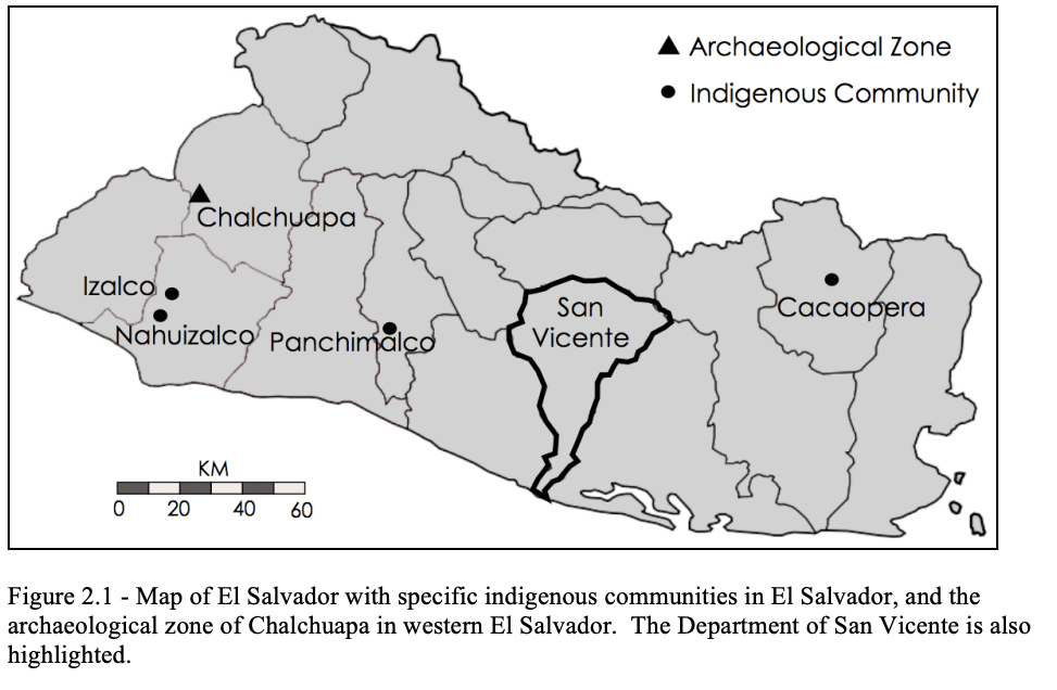
Map of El Salvador with Specific indigenous communities in El Salvador, and the archaeological zone of Chalchuapa in western El Salvador. The Department of San Vicente is also highlighted.

  • GOMEZ, ESTEBAN MONTES

Published: 2010

  • Download Image

Peoples

  • IZALCO
  • NAHUIZALCO
  • PANCHIMALCO
  • CACAOPERA

Citation

Goméz, Esteban Montes. "Map of El Salvador with Specific indigenous communities in El Salvador, and the archaeological zone of Chalchuapa in western El Salvador. The Department of San Vicente is also highlighted." IN Archaeology of the Colonial Period Gulf of Fonseca, Eastern El Salvador" PhD Diss. University of California, Berkeley. 2010. pg. 35. https://escholarship.org/content/qt3h6908bz/qt3h6908bz_noSplash_63ed1d6868d6a9d562c348d2708ea5fb.pdf
  • Download Image

Reading in Spanish

Map 2010

Map of El Salvador with Specific indigenous communities in El Salvador, and the archaeological zone of Chalchuapa in western El Salvador. The Department of San Vicente is also highlighted.

  • GOMEZ, ESTEBAN MONTES

Published: 2010

  • Download Image
  • Download Image

Related Content

PLAN de la Ville de l’Assomption, dans LE PARAGUAY

PLAN de la Ville de l’Assomption, dans LE PARAGUAY

Map 1781
Nieuwe Caerte van het wonderbaer ende goudrijcke landt Guiana, gelegen onder de Linie Aequinoctiael tusschen Brasilien ende Péru.

Nieuwe Caerte van het wonderbaer ende goudrijcke landt Guiana, gelegen onder de Linie Aequinoctiael tusschen Brasilien ende Péru.

Map 1500 - 1599
La Guyane Francoise, avec partie de la Guyane Hollandoise: suivant les Opérations et les Cartes récentes;des Ingênieurs-Géographes François.

La Guyane Francoise, avec partie de la Guyane Hollandoise: suivant les Opérations et les Cartes récentes;des Ingênieurs-Géographes François.

Map 1787
Das obere Stromgebiet des RIO MADEIRA, nebst den agränzenden Ländern

Das obere Stromgebiet des RIO MADEIRA, nebst den agränzenden Ländern

Map 1800 - 1850
N. 24: Guyane.

N. 24: Guyane.

Map 1800 - 1899
Map of deforestation within protected areas in Guatemala and adjoining areas

Map of deforestation within protected areas in Guatemala and adjoining areas

Map 2000 - 2100
Carte de la Guyane et des territoires limitrophes (Traité d'arbitrage, signé à Londres le 6 novembre 1901)

Carte de la Guyane et des territoires limitrophes (Traité d'arbitrage, signé à Londres le 6 novembre 1901)

Map 1900 - 1999
What did they actually see?
“Out of control” Pag-127 / “Deviant” Pag-128 / “Possessed” Pag-129 2018

What did they actually see? “Out of control” Pag-127 / “Deviant” Pag-128 / “Possessed” Pag-129 2018

Artwork

Dispossessions in the Americas

A project by

University of Pennsylvania

Copyright 2024

With support from

Mellon Foundation

Site design & development

Element 84

Art Credits

Goméz, Esteban Montes. “Map of El Salvador with Specific indigenous communities in El Salvador, and the archaeological zone of Chalchuapa in western El Salvador. The Department of San Vicente is also highlighted.” IN Archaeology of the Colonial Period Gulf of Fonseca, Eastern El Salvador" PhD Diss. University of California, Berkeley. 2010. pg. 35. https://escholarship.org/content/qt3h6908bz/qt3h6908bz_noSplash_63ed1d6868d6a9d562c348d2708ea5fb.pdf
Site Pages

  • Home
  • Explore
  • About
  • Authors
  • Art
  • Bodies
  • Curricula
  • Cultural Heritage
  • Maps
  • Territories