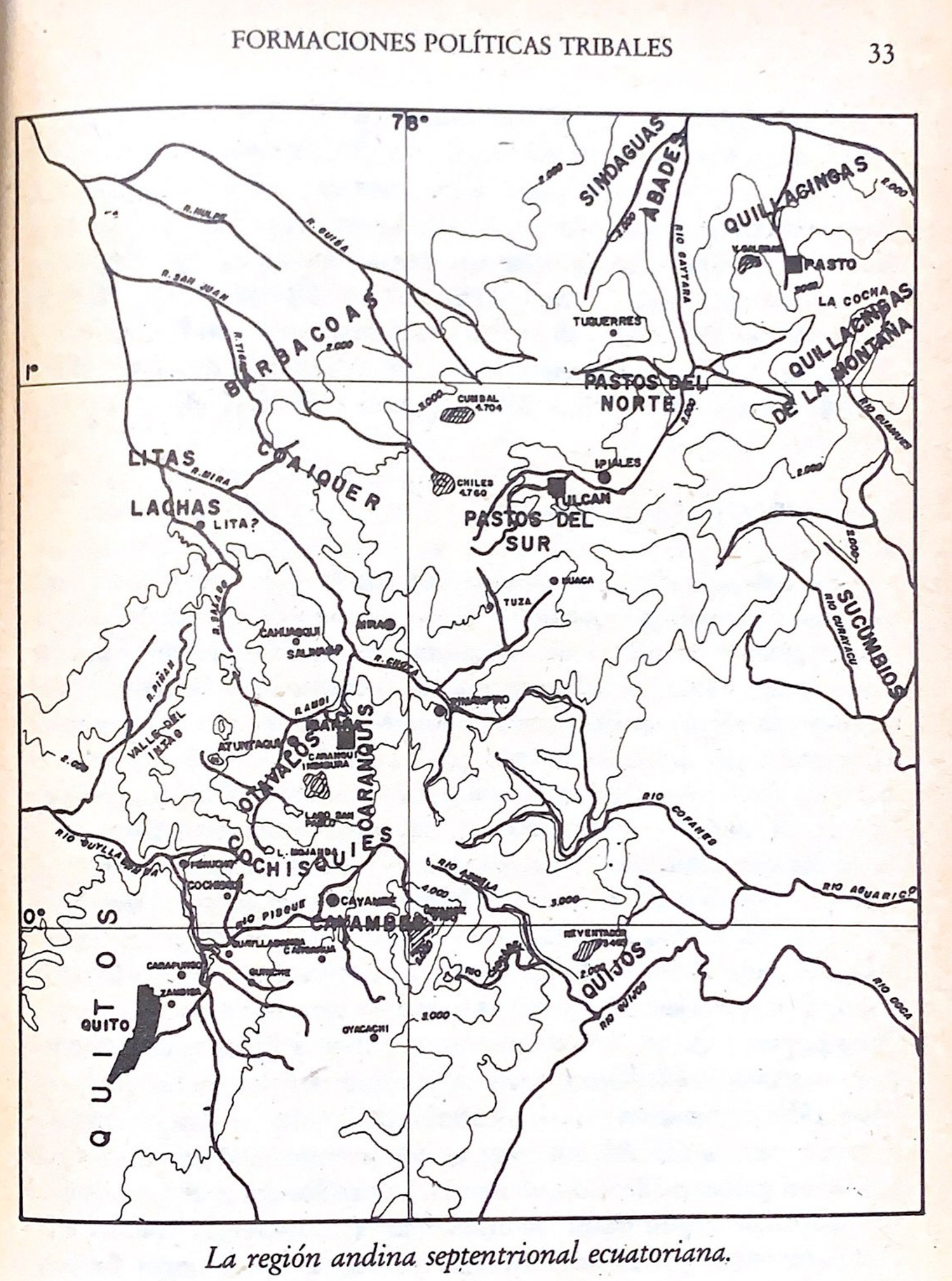
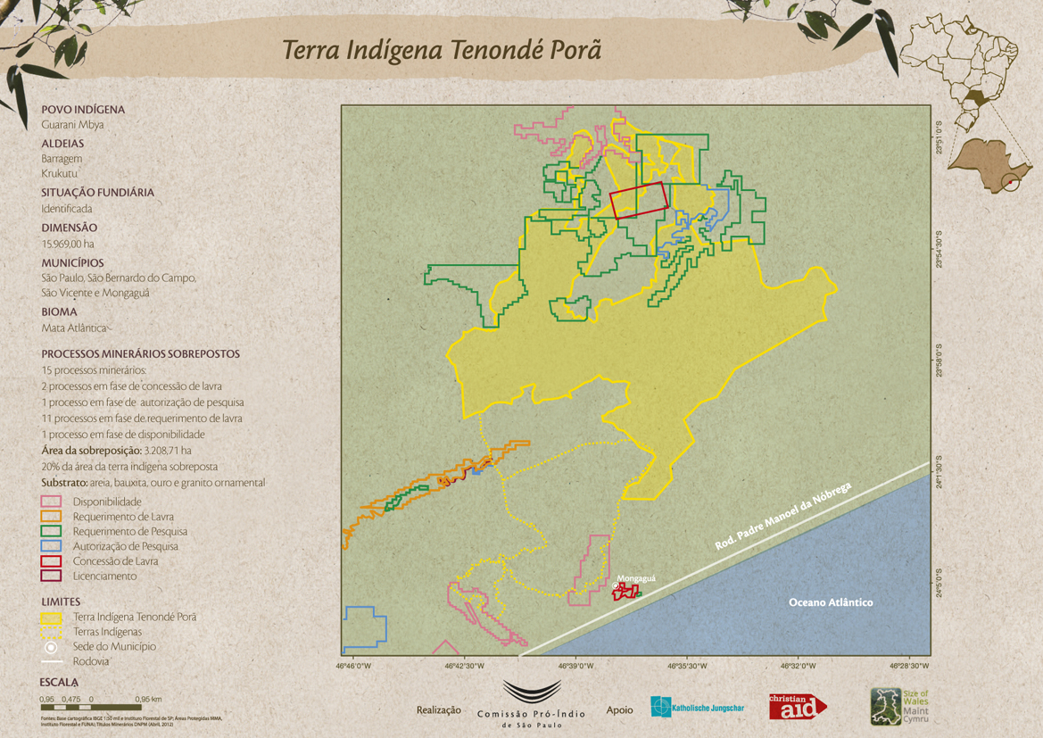
Dispossesions in the Americas

Dispossesions in the Americas

  • Home
  • Explore
  • About
  • Authors
  • Art
  • Bodies
  • Curricula
  • Cultural Heritage
  • Maps
  • Territories
Back to Explore
Map -500 - 1550

La región andina septentrional ecuatoriana

  • ENRIQUE AYALA MORA

Published: 1983

  • Download Image

Peoples

  • BARBACOAS
  • SINDAGUAS
  • QUILLACINGAS
  • PASTOS
  • AWA
  • LITAS
  • LACHA
  • KICHWA
  • OTAVALOS
  • CARANQUIS
  • KITU-KARA
  • QUIJOS
  • CAYAMBES

Citation

Ayala Mora;Enrique. Nueva historia del Ecuador. V2. Quito;Ecuador: Corporación Editora Nacional;1983. https://upenn.alma.exlibrisgroup.com/discovery/fulldisplay?vid=01UPENN_INST:Services&id=9918706893503681&inst=01UPENN_INST&context=L

  • Download Image

Reading in Spanish

Map -500 - 1550

La región andina septentrional ecuatoriana

  • ENRIQUE AYALA MORA

Published: 1983

  • Download Image
  • Download Image

Reading in Portuguese

Map -500 - 1550

La región andina septentrional ecuatoriana

  • ENRIQUE AYALA MORA

Published: 1983

  • Download Image

Peoples

  • BARBACOAS
  • SINDAGUAS
  • QUILLACINGAS
  • PASTOS
  • AWA
  • LITAS
  • LACHA
  • KICHWA
  • OTAVALOS
  • CARANQUIS
  • KITU-KARA
  • QUIJOS
  • CAYAMBES

Citation

Ayala Mora;Enrique. Nueva historia del Ecuador. V2. Quito;Ecuador: Corporación Editora Nacional;1983. https://upenn.alma.exlibrisgroup.com/discovery/fulldisplay?vid=01UPENN_INST:Services&id=9918706893503681&inst=01UPENN_INST&context=L

  • Download Image

Related Content

Terra Indígena Tenondé Porã

Terra Indígena Tenondé Porã

Map 2012
Carte du Pérou et Brésil sep.l de Tierra-Firme, de Guyana, et de la Rivière des Amazones: Ce qui fait la partie Boréale de l'Amérique Meridio. le. Par le Sr. D' Anville

Carte du Pérou et Brésil sep.l de Tierra-Firme, de Guyana, et de la Rivière des Amazones: Ce qui fait la partie Boréale de l'Amérique Meridio. le. Par le Sr. D' Anville

Map 1700 - 1799
GUANÁ

GUANÁ

Map 2015
Victoria regia [Giant Water Lily]

Victoria regia [Giant Water Lily]

Artwork
Geographic Map of the Nicaragua with three plans and views.

Geographic Map of the Nicaragua with three plans and views.

Map 1855
BRAZIL

BRAZIL

Map 1855
The Great River Marañon or of the Amazons

The Great River Marañon or of the Amazons

Map 1717
PUEBLO MIXE

PUEBLO MIXE

Map 2020

Dispossessions in the Americas

A project by

University of Pennsylvania

Copyright 2024

With support from

Mellon Foundation

Site design & development

Element 84

Art Credits

Ayala Mora;Enrique. Nueva historia del Ecuador. V2. Quito;Ecuador: Corporación Editora Nacional;1983. https://upenn.alma.exlibrisgroup.com/discovery/fulldisplay?vid=01UPENN_INST:Services&id=9918706893503681&inst=01UPENN_INST&context=L

Site Pages

  • Home
  • Explore
  • About
  • Authors
  • Art
  • Bodies
  • Curricula
  • Cultural Heritage
  • Maps
  • Territories