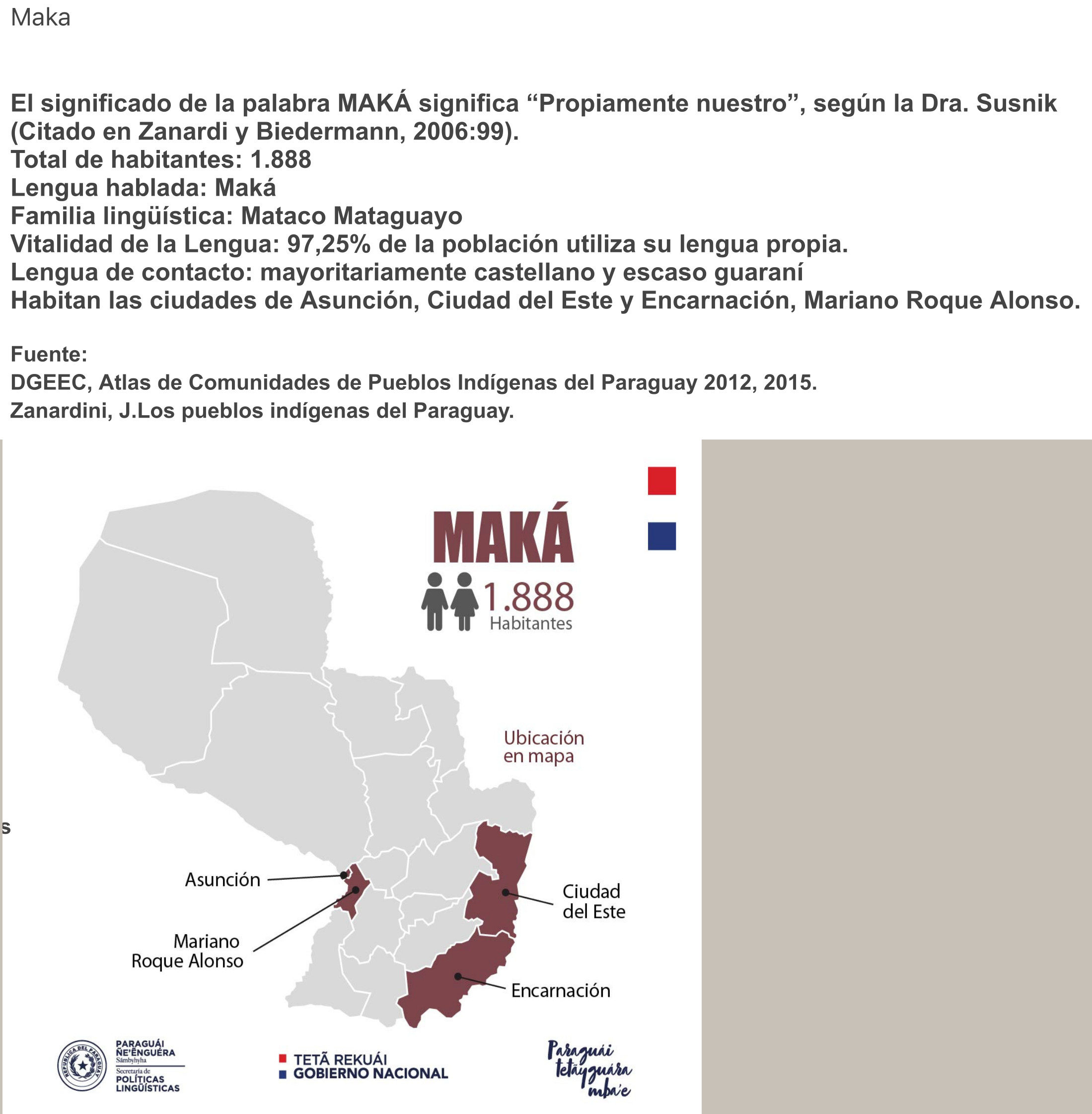
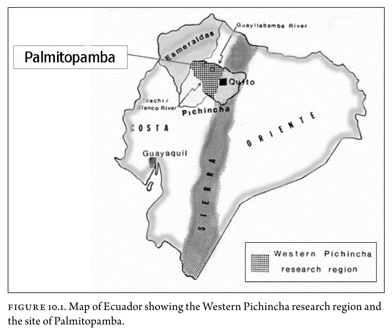
Dispossesions in the Americas

Dispossesions in the Americas

  • Home
  • Explore
  • About
  • Authors
  • Art
  • Bodies
  • Curricula
  • Cultural Heritage
  • Maps
  • Territories
Back to Explore
Map -700 - 1534

Figure 10.1. Map of Ecuador showing the Western Pichincha research region and the site of Palmitopamba.

  • RONALD D. LIPPI AND ALEJANDRA M. GUDIÑO)

Published: 2010

  • Download Image

Peoples

  • YUMBOS
  • BARBACOA

Citation

Malpass;M. A.;& Alconini;S. (Eds.). (2010). Distant provinces in the inka empire : Toward a deeper understanding of inka imperialism. University of Iowa Press.Created from upenn-ebooks on 2022-09-02 16:11:14. https://upenn.alma.exlibrisgroup.com/discovery/openurl?institution=01UPENN_INST&vid=01UPENN_INST:Services&%3Fctx_ver=Z39.88-2004&ctx_enc=info:ofi%2Fenc:UTF-8&rfr_id=info:sid%2Fsummon.serialssolutions.com&rft_val_fmt=info:ofi%2Ffmt:kev:mtx:book&rft.genre=book&rft.title=Distant%20provinces%20in%20the%20inka%20empire:%20Toward%20a%20Deeper%20Understanding%20of%20Inka%20Imperialism&rft.au=Malpass%20Prof;%20Michael%20A.&rft.au=Alconini;%20Sonia&rft.date=2010-01-01&rft.isbn=9781587298691&rft.externalDBID=n%2Fa&rft.externalDocID=255354928

  • Download Image

Reading in Spanish

Map -700 - 1534

Figure 10.1. Map of Ecuador showing the Western Pichincha research region and the site of Palmitopamba.

  • RONALD D. LIPPI AND ALEJANDRA M. GUDIÑO)

Published: 2010

  • Download Image
  • Download Image

Related Content

Carte n°7: Limite septentrionale des poissons Paraiba et Pirarucu

Carte n°7: Limite septentrionale des poissons Paraiba et Pirarucu

Map 1740 - 1978
NLLE. GRENADE CARACAS ET GUYANES.

NLLE. GRENADE CARACAS ET GUYANES.

Map 1812
Los Garífuna: Most important municipios, 2001

Los Garífuna: Most important municipios, 2001

Map 2001
Guatemala, from official and other sources.

Guatemala, from official and other sources.

Map 1900
The Tribes of Southern South America;at the first European contact period

The Tribes of Southern South America;at the first European contact period

Map 1512
PUEBLO CHAPRA

PUEBLO CHAPRA

Map 2021
Mapa de las barras de la laguna de Maracaibo;de la ensenada que ay entre los dos cabos de Sancta Anna y Chichibacoa;y parte de las costas que desde ellos corren assí al este y vueste;cuyos paízes se reconocerán por sus demonstratibos;y las distancias por el tronco de dies leguas castellanas que son las que parecen abaxo

Mapa de las barras de la laguna de Maracaibo;de la ensenada que ay entre los dos cabos de Sancta Anna y Chichibacoa;y parte de las costas que desde ellos corren assí al este y vueste;cuyos paízes se reconocerán por sus demonstratibos;y las distancias por el tronco de dies leguas castellanas que son las que parecen abaxo

Map 1740 - 1750
The Spanish and Musketor shore and the bay of Honduras and the islands adjacent

The Spanish and Musketor shore and the bay of Honduras and the islands adjacent

Map 1735

Dispossessions in the Americas

A project by

University of Pennsylvania

Copyright 2024

With support from

Mellon Foundation

Site design & development

Element 84

Art Credits

Malpass;M. A.;& Alconini;S. (Eds.). (2010). Distant provinces in the inka empire : Toward a deeper understanding of inka imperialism. University of Iowa Press.Created from upenn-ebooks on 2022-09-02 16:11:14. https://upenn.alma.exlibrisgroup.com/discovery/openurl?institution=01UPENN_INST&vid=01UPENN_INST:Services&%3Fctx_ver=Z39.88-2004&ctx_enc=info:ofi%2Fenc:UTF-8&rfr_id=info:sid%2Fsummon.serialssolutions.com&rft_val_fmt=info:ofi%2Ffmt:kev:mtx:book&rft.genre=book&rft.title=Distant%20provinces%20in%20the%20inka%20empire:%20Toward%20a%20Deeper%20Understanding%20of%20Inka%20Imperialism&rft.au=Malpass%20Prof;%20Michael%20A.&rft.au=Alconini;%20Sonia&rft.date=2010-01-01&rft.isbn=9781587298691&rft.externalDBID=n%2Fa&rft.externalDocID=255354928

Site Pages

  • Home
  • Explore
  • About
  • Authors
  • Art
  • Bodies
  • Curricula
  • Cultural Heritage
  • Maps
  • Territories