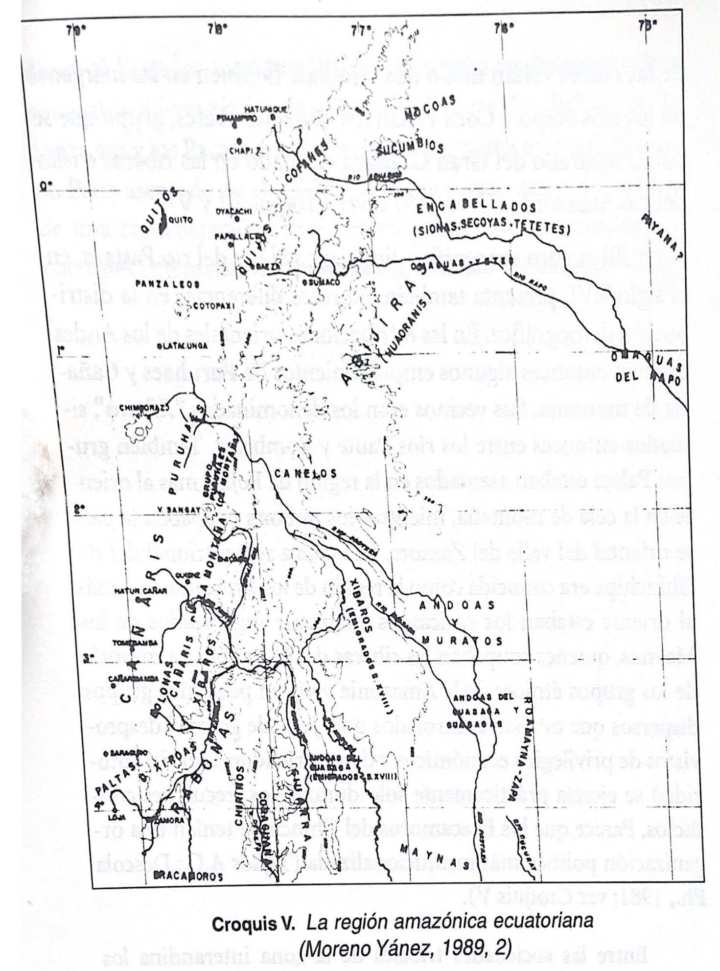
Dispossesions in the Americas

Dispossesions in the Americas

  • Home
  • Explore
  • About
  • Authors
  • Art
  • Bodies
  • Curricula
  • Cultural Heritage
  • Maps
  • Territories
Back to Explore
Map -500 - 1530

Croquis V. La región amazónica ecuatoriana (Moreno Yanez;1989;2)

  • SEGUNDO E. MORENO YANEZ

Published: 1989

  • Download Image

Peoples

  • YUMBOS
  • PUCARA
  • CARANQUI

Citation

Borchart de Moreno;Christiana Renate;and Segundo. Moreno Yáñez. Crónica indiana del Ecuador antiguo. Quito: Proyecto EBI-GTZ;1997. https://upenn.alma.exlibrisgroup.com/discovery/fulldisplay?vid=01UPENN_INST:Services&id=9923438013503681&inst=01UPENN_INST&context=L

  • Download Image

Reading in Spanish

Map -500 - 1530

Croquis V. La región amazónica ecuatoriana (Moreno Yanez;1989;2)

  • SEGUNDO E. MORENO YANEZ

Published: 1989

  • Download Image
  • Download Image

Reading in Portuguese

Map -500 - 1530

Croquis V. La región amazónica ecuatoriana (Moreno Yanez;1989;2)

  • SEGUNDO E. MORENO YANEZ

Published: 1989

  • Download Image

Peoples

  • YUMBOS
  • PUCARA
  • CARANQUI

Citation

Borchart de Moreno;Christiana Renate;and Segundo. Moreno Yáñez. Crónica indiana del Ecuador antiguo. Quito: Proyecto EBI-GTZ;1997. https://upenn.alma.exlibrisgroup.com/discovery/fulldisplay?vid=01UPENN_INST:Services&id=9923438013503681&inst=01UPENN_INST&context=L

  • Download Image

Related Content

LENGUAS INDÍGENAS

LENGUAS INDÍGENAS

Map 2016
The Eight Pueblos, 1947

The Eight Pueblos, 1947

Map 1947
NORTHWEST PART OF THE "GREAT COLONIAL MAP"

NORTHWEST PART OF THE "GREAT COLONIAL MAP"

Map 1875
The provinces of La Plata, the Banda Oriental del Uruguay and Chile.

The provinces of La Plata, the Banda Oriental del Uruguay and Chile.

Map 1842
JALISCO

JALISCO

Map 2015
Map of Mapuche Land Dispossession for Chilean and German Settlers

Map of Mapuche Land Dispossession for Chilean and German Settlers

Map 1911 - 1952
Map of Honduras and San Salvador, Central America, Showing the line of the proposed Honduras Interoceanic Railway

Map of Honduras and San Salvador, Central America, Showing the line of the proposed Honduras Interoceanic Railway

Map 1854
[Embouchure de l'Oyapock].

[Embouchure de l'Oyapock].

Map 1700 - 1799

Dispossessions in the Americas

A project by

University of Pennsylvania

Copyright 2024

With support from

Mellon Foundation

Site design & development

Element 84

Art Credits

Borchart de Moreno;Christiana Renate;and Segundo. Moreno Yáñez. Crónica indiana del Ecuador antiguo. Quito: Proyecto EBI-GTZ;1997. https://upenn.alma.exlibrisgroup.com/discovery/fulldisplay?vid=01UPENN_INST:Services&id=9923438013503681&inst=01UPENN_INST&context=L

Site Pages

  • Home
  • Explore
  • About
  • Authors
  • Art
  • Bodies
  • Curricula
  • Cultural Heritage
  • Maps
  • Territories