Dispossesions in the Americas

Dispossesions in the Americas

  • Home
  • Explore
  • About
  • Authors
  • Art
  • Bodies
  • Curricula
  • Cultural Heritage
  • Maps
  • Territories
Back to Explore
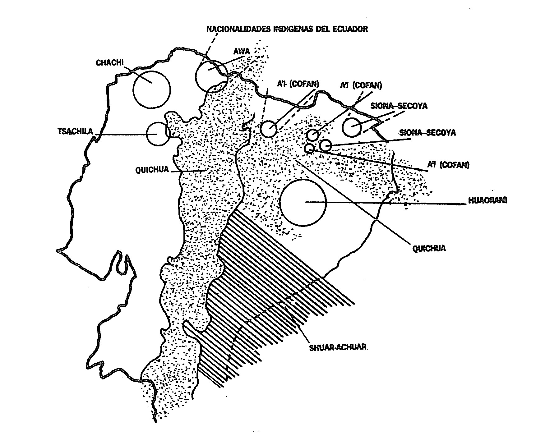
Map 1988

NACIONALIDADES INDÍGENAS DEL ECUADOR

  • CONAIE

Published: 1988

  • Download Image

Peoples

  • KICHWA
  • CHACHI
  • TSACHILA
  • AWA
  • AI COFAN
  • SIONA-SECOYA
  • WAORANI
  • SHUAR
  • ACHUAR

Citation

CONAIE. 1988. Derechos Humanos Y Solidaridad de los Pueblos Indigenas. Quito: CONAIE. https://drive.google.com/drive/folders/0B9xnvkmElMEAdUVPdTJsX1A1Y2s?resourcekey=0-o2d5A0qCSbO779m5D9a0Ig
  • Download Image

Reading in Spanish

Map 1988

NACIONALIDADES INDÍGENAS DEL ECUADOR

  • CONAIE

Published: 1988

  • Download Image
  • Download Image

Related Content

XXI. Cours du Rio Guaviare et de la partie de l'Apure comprise entre la ville de San-Fernando et le confluent de l'Apure avec l'Orenoque.

XXI. Cours du Rio Guaviare et de la partie de l'Apure comprise entre la ville de San-Fernando et le confluent de l'Apure avec l'Orenoque.

Map 1799 - 1804
The Barima River as depicted on Dixon's compass traverse and the AGS million-scale map published in 1940 (bottom)

The Barima River as depicted on Dixon's compass traverse and the AGS million-scale map published in 1940 (bottom)

Map 1895
SPATIAL ORGANIZATION OF THE QULLASUYU UNDER INCA RULE

SPATIAL ORGANIZATION OF THE QULLASUYU UNDER INCA RULE

Map 1500 - 1530
Provincia de Zacatecas

Provincia de Zacatecas

Map 1600 - 1699
Map of Sonora, Showing Historic Location of Pima Bajo, Opata, Papago, and Seri Indians in 1960

Map of Sonora, Showing Historic Location of Pima Bajo, Opata, Papago, and Seri Indians in 1960

Map 1960
Principales poblados de la Verapaz y localización de los idomas d ela zona, siglo XVI.

Principales poblados de la Verapaz y localización de los idomas d ela zona, siglo XVI.

Map 1600
LOS GRUPOS LOCALES AYOREO DENTRO DE SU TERRITORIO

LOS GRUPOS LOCALES AYOREO DENTRO DE SU TERRITORIO

Map 1490
AMER. MÈR. PARTIE DE LA PLATA. N. 26.

AMER. MÈR. PARTIE DE LA PLATA. N. 26.

Map 1825

Dispossessions in the Americas

A project by

University of Pennsylvania

Copyright 2024

With support from

Mellon Foundation

Site design & development

Element 84

Art Credits

CONAIE. 1988. Derechos Humanos Y Solidaridad de los Pueblos Indigenas. Quito: CONAIE. https://drive.google.com/drive/folders/0B9xnvkmElMEAdUVPdTJsX1A1Y2s?resourcekey=0-o2d5A0qCSbO779m5D9a0Ig
Site Pages

  • Home
  • Explore
  • About
  • Authors
  • Art
  • Bodies
  • Curricula
  • Cultural Heritage
  • Maps
  • Territories