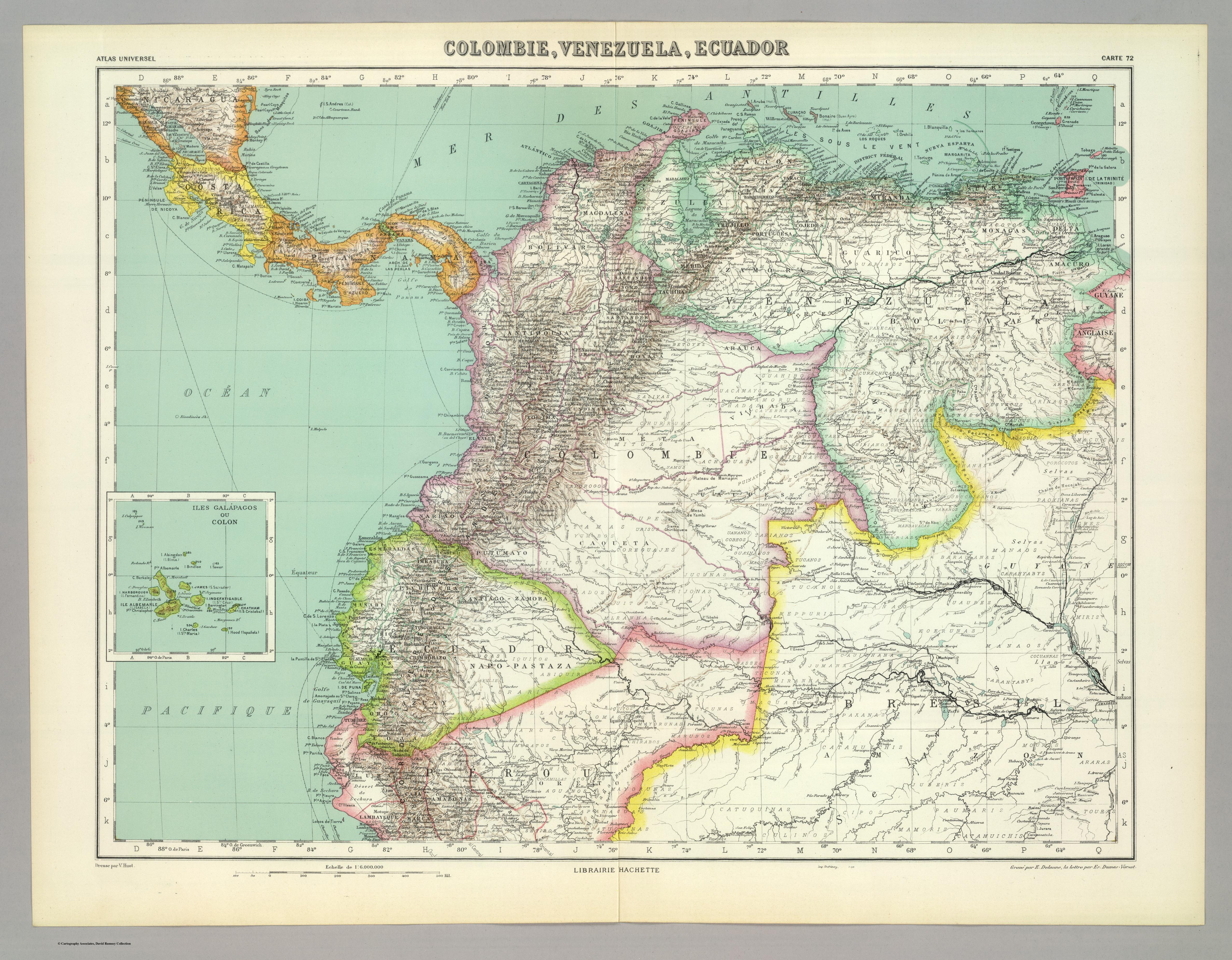
Dispossesions in the Americas

Dispossesions in the Americas

  • Home
  • Explore
  • About
  • Authors
  • Art
  • Bodies
  • Curricula
  • Cultural Heritage
  • Maps
  • Territories
Back to Explore
Map

PRIMERAS CULTURAS QUITENAS - LA AMAZONIA - GENEALOGÍA - INVASIONES MAYAS

  • JUAN MORALES Y ELOY

Published: 1942

  • Download Image

Peoples

  • AIMARAES
  • ARAWACAS
  • ARDAS
  • ATACAMENOS-CHINCHAS
  • BARBACOAS
  • BETOYAS
  • BRACAMOROS
  • CAGUAPANAS
  • CAJAMARCA
  • CANARIC
  • CARANQUI
  • CARAS
  • CARCHI
  • CARIBES
  • CARIOS
  • CAYAPAS
  • CHAVIN
  • CHARCAS
  • CHIBCHAS
  • CHIMU
  • CHINCHAS
  • CHIRIQUI
  • CHOCO
  • CHOROTEGAS
  • CHUQUIMAYO
  • COCAMAS
  • COFANES
  • COLORADOS
  • CORREGUAJES
  • CUNAS
  • DORASCOS
  • ENCABELLADOS
  • GUAIMIS
  • GUATUZOS
  • GUETARES
  • ICAGUATES
  • IMBAYA
  • IQUITOS
  • ITZAES
  • JIVAROS
  • KARAS
  • LAMBAYEQUE
  • MANGUES
  • MANTAS
  • MAYAS
  • MAZAYES
  • MOCHICAS
  • MOCOAS
  • MUISCAS
  • NAHUAS
  • NAPOS
  • OLMECAS
  • OREJONES
  • PACAMUROS
  • PAESES
  • PANOS
  • PALTAS
  • PANIQUITAS
  • PASTOS
  • PEBAS
  • PURUHAES
  • QUILLASINGAS
  • QUIMBAYA
  • QUITCHES
  • QUITUS
  • QUIXOS
  • RECUAY
  • SHUAR
  • TALAMANCAS
  • TAMAS
  • TEREVIS
  • TIAHUANACO
  • TICUNAS
  • TUMPIS
  • TUNCAHUAN
  • TUCANOS
  • TINCULLPAS
  • URARINAS
  • UROS
  • YAGUAS
  • YAMEOS
  • YUNCAS
  • YUNGAS
  • ZAPAROS
  • ZAPOTECAS
  • ZARZAS

Citation

MORALES ELOY JUAN. ECUADOR;ATLAS HISTÓRICO-GEOGRÁFICO;- QUITO;LOS ORIGENES;EL REINO;LA AUDIENCIA Y PRESIDENCIA;LA REPÚBLICA;2021. https://upenn.alma.exlibrisgroup.com/discovery/fulldisplay?vid=01UPENN_INST:Services&id=9978120315103681&inst=01UPENN_INST&context=L

  • Download Image

Reading in Spanish

Map

PRIMERAS CULTURAS QUITENAS - LA AMAZONIA - GENEALOGÍA - INVASIONES MAYAS

  • JUAN MORALES Y ELOY

Published: 1942

  • Download Image
  • Download Image

Related Content

Carte géographique de l'isle de Cayenne et de ses environs dressée sur les observations estimées et les remarques de Mr de Préfontaine

Carte géographique de l'isle de Cayenne et de ses environs dressée sur les observations estimées et les remarques de Mr de Préfontaine

Map 1747 - 1762
Partie de Terre Ferme ou sont Guiane et Caribane. Augmentée et Corrigée suivant les dernières Relations

Partie de Terre Ferme ou sont Guiane et Caribane. Augmentée et Corrigée suivant les dernières Relations

Map 1594 - 1596
LE BRESIL divisé en ses capitaineries suivant les relations les plus nouvelles

LE BRESIL divisé en ses capitaineries suivant les relations les plus nouvelles

Map 1600 - 1650
Northern Mexico and a Portion of Texas 1600-1750 Showing the approximate Locations of Indian tribes

Northern Mexico and a Portion of Texas 1600-1750 Showing the approximate Locations of Indian tribes

Map 1600 - 1750
Primary Maroon communities in Jamaica

Primary Maroon communities in Jamaica

Map 2015
REGIÓN SELVA LACANDONA

REGIÓN SELVA LACANDONA

Map 2000
REPUBLICA ARGENTINA CHILE-URUGUAY-PARAGUAY

REPUBLICA ARGENTINA CHILE-URUGUAY-PARAGUAY

Map 1884
Côte du Perou

Côte du Perou

Map 1707

Dispossessions in the Americas

A project by

University of Pennsylvania

Copyright 2024

With support from

Mellon Foundation

Site design & development

Element 84

Art Credits

MORALES ELOY JUAN. ECUADOR;ATLAS HISTÓRICO-GEOGRÁFICO;- QUITO;LOS ORIGENES;EL REINO;LA AUDIENCIA Y PRESIDENCIA;LA REPÚBLICA;2021. https://upenn.alma.exlibrisgroup.com/discovery/fulldisplay?vid=01UPENN_INST:Services&id=9978120315103681&inst=01UPENN_INST&context=L

Site Pages

  • Home
  • Explore
  • About
  • Authors
  • Art
  • Bodies
  • Curricula
  • Cultural Heritage
  • Maps
  • Territories