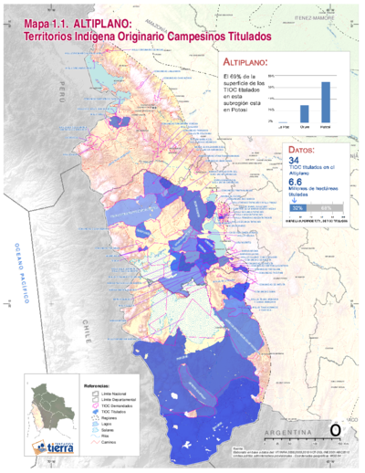
Dispossesions in the Americas

Dispossesions in the Americas

  • Home
  • Explore
  • About
  • Authors
  • Art
  • Bodies
  • Curricula
  • Cultural Heritage
  • Maps
  • Territories
Back to Explore
Map 1958

MAPA 1. TERRITORIOS DE LOS GRUPOS HUAORANI AL TIEMPO DE CONTACTO

  • JAMES A YOST

Published: 1981

  • Download Image

Peoples

  • WAORANI

Citation

Yost;James A. Viente Años De Contacto: Los Mecanismos De Cambio En La Cultura Huao (AUCA). Instituto Lingüı́stico de Verano;Ministerio de Educacion y Cultura;1981. https://www.sil.org/system/files/reapdata/62/02/26/62022605750761590158806722366579601952/21910.pdf

  • Download Image

Reading in Spanish

Map 1958

MAPA 1. TERRITORIOS DE LOS GRUPOS HUAORANI AL TIEMPO DE CONTACTO

  • JAMES A YOST

Published: 1981

  • Download Image
  • Download Image

Reading in Portuguese

Map 1958

MAPA 1. TERRITORIOS DE LOS GRUPOS HUAORANI AL TIEMPO DE CONTACTO

  • JAMES A YOST

Published: 1981

  • Download Image

Peoples

  • WAORANI

Citation

Yost;James A. Viente Años De Contacto: Los Mecanismos De Cambio En La Cultura Huao (AUCA). Instituto Lingüı́stico de Verano;Ministerio de Educacion y Cultura;1981. https://www.sil.org/system/files/reapdata/62/02/26/62022605750761590158806722366579601952/21910.pdf

  • Download Image

Related Content

PUEBLO CHONTAL DE TABASCO

PUEBLO CHONTAL DE TABASCO

Map 2020
MAPA DE TEPETLAOZTOC

MAPA DE TEPETLAOZTOC

Map 1500 - 1599
Mapa de una parte del Rio Yapurá : comprehendida desde la boca del Caño de Avatiparána immediata al pueblo de Maripi hasta la boca del Rio Apaporis proxima al Salto de Cupati

Mapa de una parte del Rio Yapurá : comprehendida desde la boca del Caño de Avatiparána immediata al pueblo de Maripi hasta la boca del Rio Apaporis proxima al Salto de Cupati

Map 1788
CARTA GEOGRÁFICA DEL ECUADOR POR DR. TEODORO WOLF;PUBLICADA POR ORDEN DEL SUPREMO GOBIERNO DE LA REPÚBLICA Y TRABAJADA BAJO LAS PRESIDENCIAS DE LOS EE. SEÑORES DR. D.J.M. PLÁCIDO CAAMAÑO Y DR. D. ANTONIO FLORES. 1892 ... INSTITUTO GEOGRAFICO DE H. WAGNER & E. DEBES EN LEIPZIG. (WITH) LA REGION ORIENTAL DEL ECUADOR. (WITH) ARCHIPIÉLAGO DE GALÁPAGOS.

CARTA GEOGRÁFICA DEL ECUADOR POR DR. TEODORO WOLF;PUBLICADA POR ORDEN DEL SUPREMO GOBIERNO DE LA REPÚBLICA Y TRABAJADA BAJO LAS PRESIDENCIAS DE LOS EE. SEÑORES DR. D.J.M. PLÁCIDO CAAMAÑO Y DR. D. ANTONIO FLORES. 1892 ... INSTITUTO GEOGRAFICO DE H. WAGNER & E. DEBES EN LEIPZIG. (WITH) LA REGION ORIENTAL DEL ECUADOR. (WITH) ARCHIPIÉLAGO DE GALÁPAGOS.

Map 1892
"Territorio Indígena Brunka de Boruca"

"Territorio Indígena Brunka de Boruca"

Map 2010
PARAGUAY

PARAGUAY

Map 1885
Nos roban las palabras o A Calzón quitado, o Insurrecciones que son heréticas resurrecciones [They steal our words or Barefaced, or Insurrections that are Heretical Resurrections]

Nos roban las palabras o A Calzón quitado, o Insurrecciones que son heréticas resurrecciones [They steal our words or Barefaced, or Insurrections that are Heretical Resurrections]

Artwork
TITLED INDIGENOUS TERRITORIES (TIOCs) IN THE BOLIVIAN HIGH PLATEAU by 2011

TITLED INDIGENOUS TERRITORIES (TIOCs) IN THE BOLIVIAN HIGH PLATEAU by 2011

Map 2011

Dispossessions in the Americas

A project by

University of Pennsylvania

Copyright 2024

With support from

Mellon Foundation

Site design & development

Element 84

Art Credits

Yost;James A. Viente Años De Contacto: Los Mecanismos De Cambio En La Cultura Huao (AUCA). Instituto Lingüı́stico de Verano;Ministerio de Educacion y Cultura;1981. https://www.sil.org/system/files/reapdata/62/02/26/62022605750761590158806722366579601952/21910.pdf

Site Pages

  • Home
  • Explore
  • About
  • Authors
  • Art
  • Bodies
  • Curricula
  • Cultural Heritage
  • Maps
  • Territories