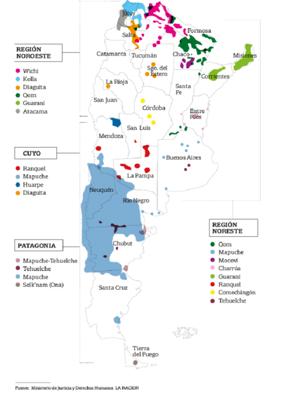
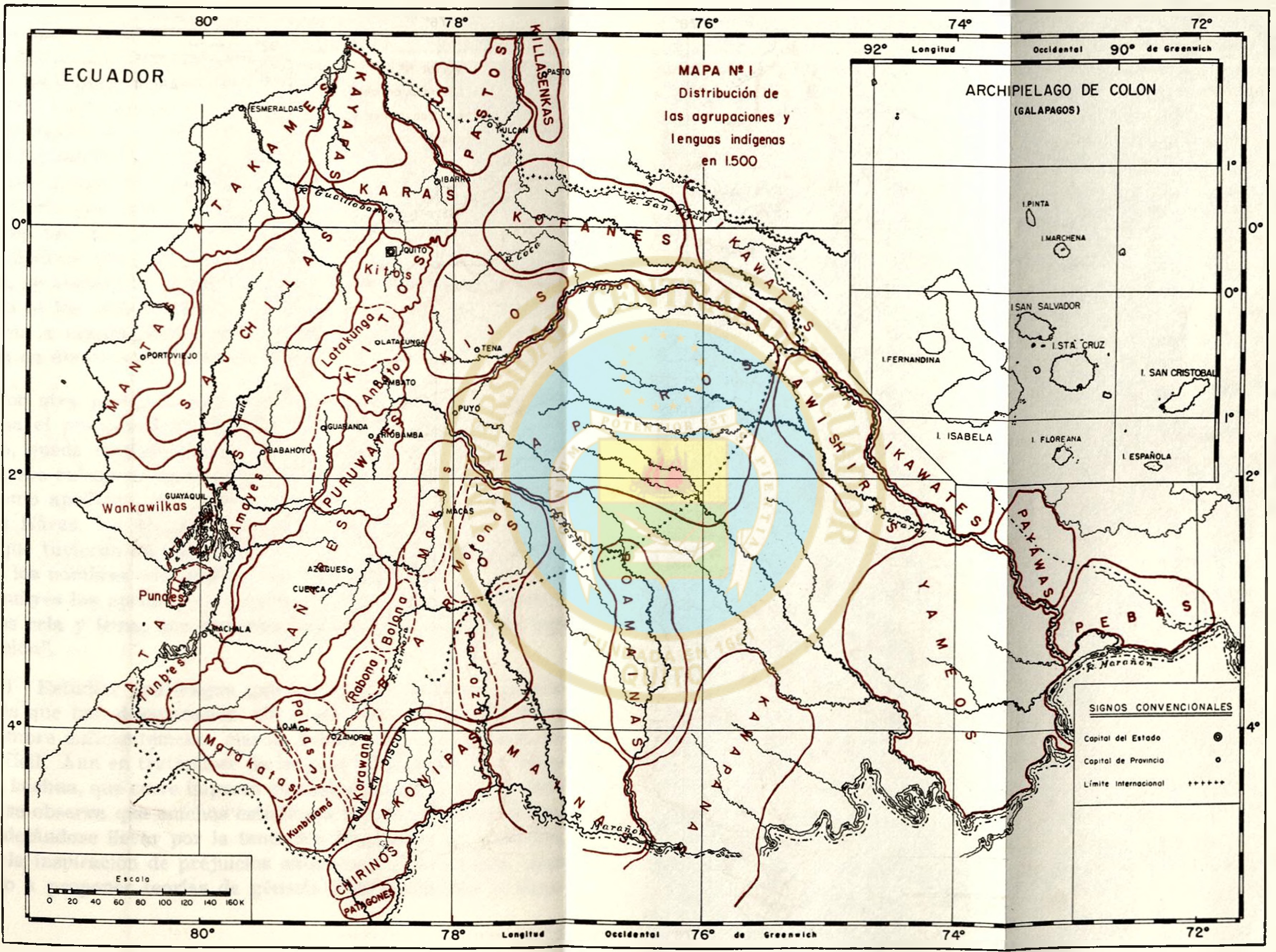
Dispossesions in the Americas

Dispossesions in the Americas

  • Home
  • Explore
  • About
  • Authors
  • Art
  • Bodies
  • Curricula
  • Cultural Heritage
  • Maps
  • Territories
Back to Explore
Map 1500

MAPA N. 1 DISTRIBUCIÓN DE LAS AGRUPACIONES Y LENGUAS INDÍGENAS EN 1500

  • LUIS PAZ Y MINO

Published: 1961

  • Download Image

Peoples

  • ATAKAMES
  • KAYAPAS
  • KARAS
  • PASTO
  • KILLASENKA
  • COFAN
  • IKAWATE
  • KIJOS
  • KITU KARA
  • SAPARA
  • MANTA
  • TSACHILA
  • HUANCAVILCA
  • PURUWA
  • QUECHUA
  • KANARI
  • PUNA
  • PALTA
  • MAINA

Citation

Paz y Miño;Luis. “Estudios Sobre La Prehistoria Ecuatoriana.” Repositorio Digital: Estudios sobre la prehistoria ecuatoriana. Quito: Industrias Gráficas CYMA;January 1;1961. http://www.dspace.uce.edu.ec/handle/25000/17994.

  • Download Image

Reading in Spanish

Map 1500

MAPA N. 1 DISTRIBUCIÓN DE LAS AGRUPACIONES Y LENGUAS INDÍGENAS EN 1500

  • LUIS PAZ Y MINO

Published: 1961

  • Download Image
  • Download Image

Reading in Portuguese

Map 1500

MAPA N. 1 DISTRIBUCIÓN DE LAS AGRUPACIONES Y LENGUAS INDÍGENAS EN 1500

  • LUIS PAZ Y MINO

Published: 1961

  • Download Image

Peoples

  • ATAKAMES
  • KAYAPAS
  • KARAS
  • PASTO
  • KILLASENKA
  • COFAN
  • IKAWATE
  • KIJOS
  • KITU KARA
  • SAPARA
  • MANTA
  • TSACHILA
  • HUANCAVILCA
  • PURUWA
  • QUECHUA
  • KANARI
  • PUNA
  • PALTA
  • MAINA

Citation

Paz y Miño;Luis. “Estudios Sobre La Prehistoria Ecuatoriana.” Repositorio Digital: Estudios sobre la prehistoria ecuatoriana. Quito: Industrias Gráficas CYMA;January 1;1961. http://www.dspace.uce.edu.ec/handle/25000/17994.

  • Download Image

Related Content

El mapa de los pueblos originarios

El mapa de los pueblos originarios

Map 2017
Pueblos Indígenas;Áreas Protegidas de Nicaragua

Pueblos Indígenas;Áreas Protegidas de Nicaragua

Map 2000
PUEBLO KUMIAI

PUEBLO KUMIAI

Map 2020
CARTE ITINÉRAIRE DU COURS DE L’ORÉNOQUE;DE L’ATABAPO;DU CASIQUIARE;ET DU RIO NEGRO OFFRANT la bifurcation de l’Orénoque et sa communication avec la Rivière des Amazones

CARTE ITINÉRAIRE DU COURS DE L’ORÉNOQUE;DE L’ATABAPO;DU CASIQUIARE;ET DU RIO NEGRO OFFRANT la bifurcation de l’Orénoque et sa communication avec la Rivière des Amazones

Map 1802
THE CARACAS

THE CARACAS

Map 1810
PUEBLO NAHUA DEL EDO DE MEXICO

PUEBLO NAHUA DEL EDO DE MEXICO

Map 2020
Tabula geographica regni Guiane Navigationes Gualteri Ralegh.

Tabula geographica regni Guiane Navigationes Gualteri Ralegh.

Map 1600 - 1699
Avá Guaraní

Avá Guaraní

Map 2001

Dispossessions in the Americas

A project by

University of Pennsylvania

Copyright 2024

With support from

Mellon Foundation

Site design & development

Element 84

Art Credits

Paz y Miño;Luis. “Estudios Sobre La Prehistoria Ecuatoriana.” Repositorio Digital: Estudios sobre la prehistoria ecuatoriana. Quito: Industrias Gráficas CYMA;January 1;1961. http://www.dspace.uce.edu.ec/handle/25000/17994.

Site Pages

  • Home
  • Explore
  • About
  • Authors
  • Art
  • Bodies
  • Curricula
  • Cultural Heritage
  • Maps
  • Territories