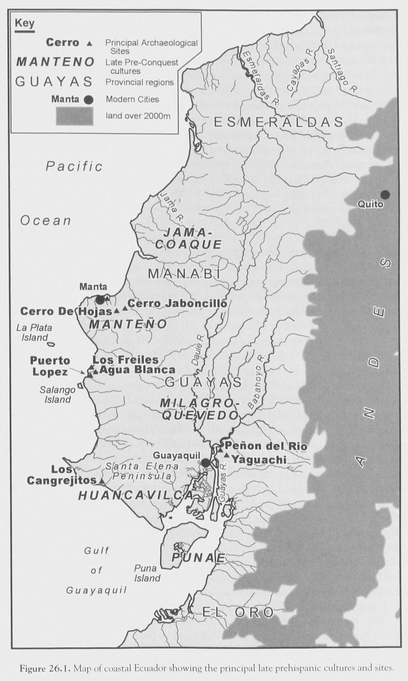
Dispossesions in the Americas

Dispossesions in the Americas

  • Home
  • Explore
  • About
  • Authors
  • Art
  • Bodies
  • Curricula
  • Cultural Heritage
  • Maps
  • Territories
Back to Explore
Map 1500

FIGURE 26.1. MAP OF COASTAL ECUADOR SHOWING THE PRINCIPAL COASTAL PREHISPANIC CULTURES AND SITES

  • COLLIN MCEWAN;FLORENCIO DELGADO-ESPINOZA

Published: 2008

  • Download Image

Peoples

  • JAMA-COAQUE
  • MANTENO
  • MILAGRO-QUEVEDO
  • HUANCAVILCA
  • PUNAE

Citation

Silverman;Helaine.;and William Harris Isbell. Handbook of South American Archaeology. New York: Springer;2008. https://franklin.library.upenn.edu/catalog/FRANKLIN_9943123073503681

  • Download Image

Reading in Spanish

Map 1500

FIGURE 26.1. MAP OF COASTAL ECUADOR SHOWING THE PRINCIPAL COASTAL PREHISPANIC CULTURES AND SITES

  • COLLIN MCEWAN;FLORENCIO DELGADO-ESPINOZA

Published: 2008

  • Download Image
  • Download Image

Reading in Portuguese

Map 1500

FIGURE 26.1. MAP OF COASTAL ECUADOR SHOWING THE PRINCIPAL COASTAL PREHISPANIC CULTURES AND SITES

  • COLLIN MCEWAN;FLORENCIO DELGADO-ESPINOZA

Published: 2008

  • Download Image

Peoples

  • JAMA-COAQUE
  • MANTENO
  • MILAGRO-QUEVEDO
  • HUANCAVILCA
  • PUNAE

Citation

Silverman;Helaine.;and William Harris Isbell. Handbook of South American Archaeology. New York: Springer;2008. https://franklin.library.upenn.edu/catalog/FRANKLIN_9943123073503681

  • Download Image

Related Content

El Vacío [The Void]

El Vacío [The Void]

Artwork
Le Paraguay

Le Paraguay

Map 1600 - 1700
Carte de l'Isle de Cayenne et de ses environs

Carte de l'Isle de Cayenne et de ses environs

Map 1764
CARTA DO SUL DO IMPERIO BRASIL, comprehandendo as PROVINCIAS RIO GRANDE do SUL, STA. CATHARINA e PARANA

CARTA DO SUL DO IMPERIO BRASIL, comprehandendo as PROVINCIAS RIO GRANDE do SUL, STA. CATHARINA e PARANA

Map 1885
BRAZIL

BRAZIL

Map 1905
Plano hidrográphico de una parte del Orinoco, que comprende desde el caño de Guaruapo hasta la ysla de Faxardo, por el qual se manifiesta que el sitio más apto para establecer el nuevo fuerte es enfrente del castillo de San Francisco de Assis de la ciudad de Guayana

Plano hidrográphico de una parte del Orinoco, que comprende desde el caño de Guaruapo hasta la ysla de Faxardo, por el qual se manifiesta que el sitio más apto para establecer el nuevo fuerte es enfrente del castillo de San Francisco de Assis de la ciudad de Guayana

Map 1747
Carte de la dépendance du fort de la rivière d'Oyapok

Carte de la dépendance du fort de la rivière d'Oyapok

Map 1700 - 1799
Indian Riots and Rebellions in Guatemala, 1679-1825

Indian Riots and Rebellions in Guatemala, 1679-1825

Map 1679 - 1825

Dispossessions in the Americas

A project by

University of Pennsylvania

Copyright 2024

With support from

Mellon Foundation

Site design & development

Element 84

Art Credits

Silverman;Helaine.;and William Harris Isbell. Handbook of South American Archaeology. New York: Springer;2008. https://franklin.library.upenn.edu/catalog/FRANKLIN_9943123073503681

Site Pages

  • Home
  • Explore
  • About
  • Authors
  • Art
  • Bodies
  • Curricula
  • Cultural Heritage
  • Maps
  • Territories