Dispossesions in the Americas

Dispossesions in the Americas

  • Home
  • Explore
  • About
  • Authors
  • Art
  • Bodies
  • Curricula
  • Cultural Heritage
  • Maps
  • Territories
Back to Explore
Map 2010

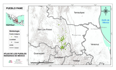
MAPA DE LOCALIZACIÓN DE NACIONALIDADES Y PUEBLOS INDÍGENAS DEL ECUADOR

  • FERNANDO PAVON

Published: 2010

  • Download Image

Peoples

  • AWA
  • CHACHI
  • EPERA
  • TSACHILA
  • COFAN
  • SECOYA
  • SIONA
  • WAORANI
  • SHUAR
  • ACHUAR
  • SHIWIAR
  • SAPARA
  • KICHWA
  • CHIBULEO
  • KARANKIL
  • KAYAMBI
  • KANARI
  • KISAPINCHA
  • KITUKARA
  • MANTA-HUANCAVILCA
  • NATABUELA
  • OTAVALO
  • PANZALEO
  • PURUHA
  • SALASACA
  • SARAGURO
  • WARANKA

Citation

Pavón;Fernando. “Mapa De Localización De Nacionalidades y Pueblos Indígenas Del Ecuador.” Oralidad y Modernidad. Proyecto Oralidad y Modernidad - Geolingüística Ecuador;August 2010. https://oralidadmodernidad.org/wp-content/uploads/1.-Nacionalidades-y-Pueblos-del-Ecuadorfinal-1.pdf-1.pdf.

  • Download Image

Reading in Spanish

Map 2010

MAPA DE LOCALIZACIÓN DE NACIONALIDADES Y PUEBLOS INDÍGENAS DEL ECUADOR

  • FERNANDO PAVON

Published: 2010

  • Download Image
  • Download Image

Related Content

Location of the main settlements on the Lenca-Chortí-Nahua-Pipil frontier, 1530-1539. (Taken from Lara-Pinto 2009 with modifications.)

Location of the main settlements on the Lenca-Chortí-Nahua-Pipil frontier, 1530-1539. (Taken from Lara-Pinto 2009 with modifications.)

Map 1530 - 1539
A Map of BRASIL and Part of LA PLATA

A Map of BRASIL and Part of LA PLATA

Map 1717
La región litoral ecuatoriana

La región litoral ecuatoriana

Map -500 - 1551
"Territorio Indígena Quitirrisí (Huétar)"

"Territorio Indígena Quitirrisí (Huétar)"

Map 2010
Carte de la Guyane française indiquant les établissements pénitentiaires, par V. A. Malte-Brun

Carte de la Guyane française indiquant les établissements pénitentiaires, par V. A. Malte-Brun

Map 1874
PUEBLO JAQARU

PUEBLO JAQARU

Map 2021
AMAZONIA;TERRAFIRMA;Part of BRASIL and PERÚ

AMAZONIA;TERRAFIRMA;Part of BRASIL and PERÚ

Map 1735
Guiana Shewing the Localities of the Principal Indian Nations

Guiana Shewing the Localities of the Principal Indian Nations

Map 1800 - 1899

Dispossessions in the Americas

A project by

University of Pennsylvania

Copyright 2024

With support from

Mellon Foundation

Site design & development

Element 84

Art Credits

Pavón;Fernando. “Mapa De Localización De Nacionalidades y Pueblos Indígenas Del Ecuador.” Oralidad y Modernidad. Proyecto Oralidad y Modernidad - Geolingüística Ecuador;August 2010. https://oralidadmodernidad.org/wp-content/uploads/1.-Nacionalidades-y-Pueblos-del-Ecuadorfinal-1.pdf-1.pdf.
Site Pages

  • Home
  • Explore
  • About
  • Authors
  • Art
  • Bodies
  • Curricula
  • Cultural Heritage
  • Maps
  • Territories